This item has been sold, but you can get on the Waitlist to be notified if another example becomes available, or purchase a digital scan.
1754 Rocque / Sayer Map of the Earl of Pembroke Garden, Wilton, England
PembrokeGarden-rocquesayer-1754$475.00

Title
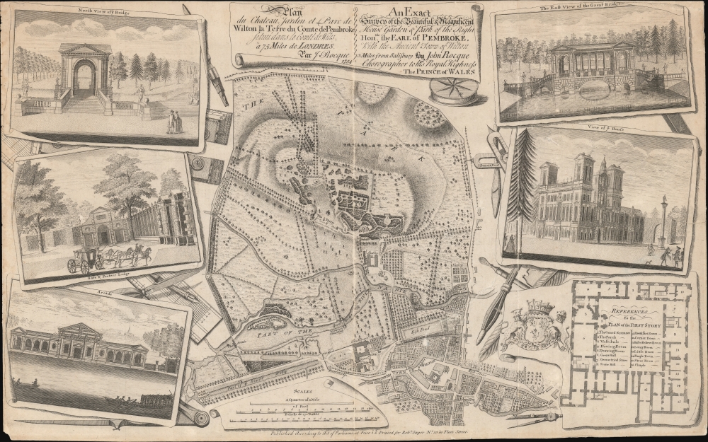
Plan du chateau, Jardin et Parc de Wilton la Terre du Comte de Pembroke, située dans la comté de Wilts. à 75 miles de Londres par J. Rocque… / An Exact Survey of the Beautiful and Magnificent House, Garden and Park of the Right Honble. the Earl of Pembroke with the ancient town of Wilton 3 miles from Salisbury…
1754 (dated) 13.75 x 21.75 in (34.925 x 55.245 cm) 1 : 4875
1754 (dated) 13.75 x 21.75 in (34.925 x 55.245 cm) 1 : 4875
Description
A striking c. 1770 John Rocque / Robert Sayer map and illustration of Wilton House, seat of the Earls of Pembroke. The map, originally issued in 1754, follows a major reworking of the gardens under Capability Brown, one of the greatest landscape designers in British history. The map takes in Wilton House, its gardens, and the nearby town of Wilton. Surrounding vignettes detail architectural features of the Wilton Gardens as well as a floor plan of the Palladian manor house.
Wilton House and Gardens
Wilton House, located near Salisbury in Wiltshire, England, is the historic seat of the Earls of Pembroke. A magnificent example of English country house Palladian architecture, its origins date back to the 1540s when it was constructed on the grounds of a 9th-century Wilton Abbey. Throughout the centuries, the house has seen numerous architectural modifications, with the most significant being the designs of the renowned Inigo Jones in the 17th century. The interiors witnessed neoclassical renovations, including the famous Double Cube Room, which was adorned with splendid artworks and was emblematic of the era's tastes. The grounds, influenced by the Naturalistic movement, underwent significant landscaping transformations under the guidance of Capability Brown (1716 - 1783), considered England's premier landscape architect, embracing a more relaxed and natural appearance. As the 18th century drew to a close, Wilton House had firmly established itself as a paragon of English architectural and landscape design. Today, the house is not only celebrated for its architectural beauty but also for its extensive art collection, landscaped gardens, and as a venue for various events and film productions.Publication History and Census
This was first drawn and engraved by John Rocque in 1754. The present example is the c. 1770 second state updated with the John Sayer imprint.CartographerS
John Rocque (1704 - 1762) was an important cartographer, engraver, and surveyor active in England and Ireland in the mid to late 18th century. Rocque is of Huguenot extraction and likely changed his name from 'Jean' upon moving to England from the south of France in 1709. John Rocque seems to have started off life as a landscape designer, working and living with his brother Bartholomew. When Rocque discovered he had a talent for cartography, he sold his skills in conjunction with his brother's landscape design work to various public parks and noble estates. Rocque is well known for his detailed plans of Plainshipp Park, Wilton House, Wrest Park, and Claremont, among others. As his cartographic skills grew he turned his attention to larger scale productions, developing a number of impressive city plans, including the exceptional large format plan of London, for which he is best remembered. Rocque enjoyed considerable business success during his lifetime. Where most English mapmakers were simply reprinting updated versions of older work, Rocque was embarking on time consuming original survey work. He also developed a number of unique approaches to cartography with regard to new techniques for rendering land use and topography - no doubt a layover of his landscape mapping work. Little is known of his personal life, though he did marry twice. His widow, Mary Ann Rocque, carried on his business following his death in 1762. More by this mapmaker...
Robert Sayer (1725 - January 29, 1794) was an important English map publisher and engraver active from the mid to late 18th century. Sayer was born in Sunderland, England, in 1725. He may have clerked as a young man with the Bank of England, but this is unclear. His brother, James Sayer, married Mary Overton, daughter-in-law of John Overton and widow of Philip Overton. Sayer initially worked under Mary Overton, but by December of 1748 was managing the Overton enterprise and gradually took it over, transitioning the plates to his own name. When Thomas Jefferys went bankrupt in 1766, Sayer offered financial assistance to help him stay in business and, in this way, acquired rights to many of the important Jefferys map plates as well as his unpublished research. From about 1774, he began publishing with his apprentice, John Bennett (fl. 1770 - 1784), as Sayer and Bennett, but the partnership was not formalized until 1777. Bennett retired in 1784 following a mental collapse and the imprint reverted to Robert Sayer. From 1790, Sayer added Robert Laurie and James Whittle to his enterprise, renaming the firm Robert Sayer and Company. Ultimately, Laurie and Whittle partnered to take over his firm. Sayer retired to Bath, where, after a long illness, he died. During most of his career, Sayer was based at 53 Fleet Street, London. His work is particularly significant for its publication of many British maps relating to the American Revolutionary War. Unlike many map makers of his generation, Sayer was a good businessman and left a personal fortune and great estate to his son, James Sayer, who never worked in the publishing business. Learn More...
Condition
Good. rimmed to neatline. Some verso repairs of closed tears. Wear on older centerfold.
References
Yale Center for British Art, Folio A G 14 and Folio B G 4. British Library, Maps K.Top.43.41.b.