This item has been sold, but you can get on the Waitlist to be notified if another example becomes available, or purchase a digital scan.
1833 S.D.U.K. Map of Pennsylvania, Virginia, Maryland, Delaware and New Jersey
PennsylvaniaNewJersey-sduk-1844$62.50

Title
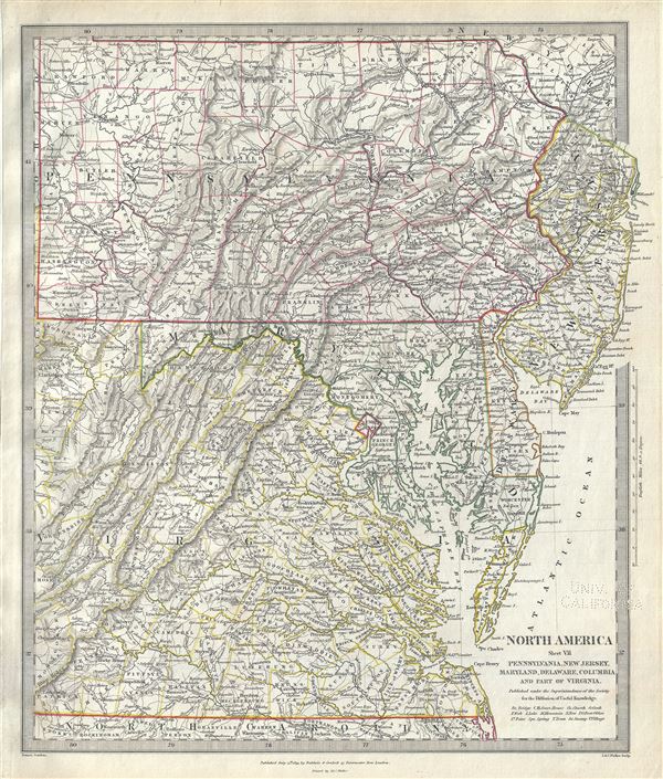
North America Sheet VII Pennsylvania, New Jersey, Maryland, Delaware, Columbia and Part of Virginia.
1833 (dated) 15.5 x 13 in (39.37 x 33.02 cm) 1 : 1770000
1833 (dated) 15.5 x 13 in (39.37 x 33.02 cm) 1 : 1770000
Description
This is a lovely 1833 map of Pennsylvania, New Jersey, Maryland, Delaware and Virginia issued by the Society for the Diffusion of Useful Knowledge or S.D.U.K. The map covers the states of Pennsylvania, New Jersey, Maryland and Delaware in full with parts of modern day Virginia and West Virginia. States are color coded with outline color. Several important topographical features including rivers, mountains, lakes, etc. are noted throughout.
The map notes the District of Columbia prior to the retrocession of Virginia, which included the lands donated by the states of Maryland and Virginia. In 1791, following the Residents Act, the District of Columbia was formed from the lands donated by the states of Maryland and Virginia. In the 1830s' after Alexandria went into economic decline due to negligence by Congress, residents petitioned Virginia to take back the donated land through retrocession. In 1847, the retrocession legislation was formally accepted and the county of Alexandria was returned to Virginia, leaving Washington County part of the District of Columbia and forming the current boundary of the county's capital, Washington DC.
This map was originally published by Baldwin and Cradock and is copyrighted in 1833, but was issued in Volume two of Chapman and Hall's 1844 edition of Maps of the Society for the Diffusion of Useful Knowledge. It was engraved by John Walker of J. and C. Walker.
CartographerS
The "Society for the Diffusion of Useful Knowledge" (1826 - 1848) was a Whiggish organization founded in 1828 at the instigation of idealistic British lord Henry Peter Brougham. The admirable goal of the Society was to distribute useful information via a series of publications to the English working and middle classes. It promoted self-education and the egalitarian sharing of all knowledge. While closely tied to the London University and publishing houses on the order of Baldwin and Cradock, Chapman and Hall, and Charles Knight, the Society failed to achieve its many lofty goals in finally closed its doors in 1848. Most likely the failure of the Society resulted from its publications being too expensive for its intended lower to middle class markets and yet not large and fine enough to appeal to the aristocratic market. Nonetheless, it did manage to publish several extraordinary atlases of impressive detail and sophistication. Their most prominent atlas consisted of some 200 separately issued maps initially published by Baldwin and Cradock and sold by subscription from 1829 to 1844. Afterwards, the Society combined the maps into a single world atlas published under the Chapman and Hall imprint. In its day, this atlas was unprecedented in its quality, scope, and cost effectiveness. Today Society, or S.D.U.K. as it is commonly known, maps are among the most impressive examples of mid-19th century English mass market cartographic publishing available. The S.D.U.K. is especially known for its beautiful and accurately detailed city plans. More by this mapmaker...
Chapman and Hall (fl. 1830 - present) was a British publishing house in London, founded in 1830 by Edward Chapman and William Hall. Upon Hall's death in 1847, Chapman's cousin Frederic Chapman became partner in the company, of which he became sole manager upon the retirement of Edward Chapman in 1864. In 1868 author Anthony Trollope bought a third of the company for his son, Henry Merivale Trollope. From 1902 to 1930 the company's managing director was Arthur Waugh. In the 1930s the company merged with Methuen, a merger which, in 1955 participated in forming the Associated Book Publishers. The latter was acquired by The Thomson Corporation in 1987. Chapman and Hall was sold again in 1998 as part of Thomson Scientific and Professional to Wolters Kluwer, who sold on its well-regarded mathematics and statistics list to CRC Press. Today the name of Chapman and Hall/CRC is used as an imprint for science and technology books by Taylor and Francis, part of the Informa group since 2004. The company is best known for its publication of the works of Charles Dickens (from 1840 until 1844 and again from 1858 until 1870), William Thackeray, Elizabeth Barrett Browning, Eadweard Muybridge and Evelyn Waugh. They continued to publish hitherto unpublished Dickens material well into the 20th century. In cartographic circles they are known as the primary publishers of the Society for the Diffusion of Useful Knowledge Atlas, a massive 200+ map atlas that was popular in England during the mid-19th century. Learn More...
John Walker (1787 - April 19, 1873) was a British map seller, engraver, lithographer, hydrographer, geographer, draughtsman, and publisher active in London during the 19th century. Walker published both nautical charts and geographical maps. His nautical work is particularly distinguished as he was an official hydrographer for the British East India Company, a position, incidentally, also held by his father of the same name. Walker's maps, mostly published after 1827, were primarily produced with his brothers Charles Walker and Alexander Walker under the imprint J. and C. Walker. Among their joint projects are more than 200 maps for the influential Society for the Diffusion of Useful Knowledge Atlas (SDUK). In addition they published numerous charts for James Horsburgh and the British Admiralty Hydrographic Office, including Belcher's important map of Hong Kong and Carless' exploratory map of Karachi. The J. and C. Walker firm continued to publish after both Walkers died in the 1870s. Learn More...
Source
Maps of the Society for the Diffusion of Useful Knowledge, (London: Chapman and Hall)
The Society for the Diffusion of Useful Knowledge (S.D.U.K.) Atlas was initially issued in parts over several years by Baldwin and Craddock to promote the society's mission of egalitarian self-education. The first S.D.U.K. began appearing in 1829 when the society contracted John Walker to produce the first proofs. The first S.D.U.K maps were produced serially by Baldwin and Craddock and issued in 2 map batches, priced at 2 shillings each. The series, originally anticipated to feature 50 maps, ultimately contained 200 and took over 14 years to produce. The initial production was completed in 1844 when the whole was issued in its first compiled atlas edition. Around 1842, following the 1837 bankruptcy of Baldwin and Craddock, publication of the atlas was taken over by the Society itself, who issued editions in 1838, 1839, 1840, 1841, and 1842. Overburdened by the work of publishing, they then outsourced the publication to Chapman and Hall in 1842. Chapman and Hall produced editions in 1842, 1843, and 1844. Dissatisfied with the quality of Chapman and Hall printing, the Society turned to another publisher, Charles Knight, who issued editions under the auspices of the Society in 1844, 1845, and 1846. In 1846 Knight officially acquired the plates in his own right and reissued in revised editions until 1852, when he sold them to George Cox. Cox in turn sold them to Edward Stanford who published them from 1856 well into the 1860s. The S.D.U.K. Atlas is known for the quantity and quality of its maps. The S.D.U.K. published many maps of areas largely ignored by other publishers. The many city plans incorporated into the atlas are particularly admired and are the highlight of the S.D.U.K.'s long map publishing history. As a whole the S.D.U.K. Atlas was groundbreaking in terms of quality, scope, and being offer at a cost effective price point.
Condition
Very good. Bears University of California Library Stamp, from which it was deaccessioned, in lower right quadrant. Minor spotting. Blank on verso.
References
Rumsey 0890.134. Phillips (Atlases) 794.