This item has been sold, but you can get on the Waitlist to be notified if another example becomes available, or purchase a digital scan.
1869 Sheafer Map of Pennsylvania showing Railroads, Canals, Coal and Oil Fields
PennsylvaniaRailroads-sheafer-1869$500.00

Title
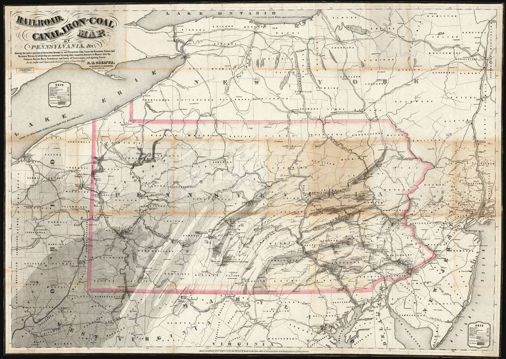
Railroad, canal, iron and coal map of Pennsylvania, etc.
1869 (dated) 29.5 x 41.5 in (74.93 x 105.41 cm) 1 : 680000
1869 (dated) 29.5 x 41.5 in (74.93 x 105.41 cm) 1 : 680000
Description
This is an 1869 Peter Wenrick Sheafer map of Pennsylvania, produced to accompany the 1868 Auditor General’s report on the Railroad and Canal companies of Pennsylvania. The map embraces all of New Jersey, most of New York, eastern Ohio and most of northern Maryland, though the industrial and mining information is restricted to the State of Pennsylvania. The presentation of that state is data-rich, showing abundant oil and coal resources and the burgeoning industrial machine linking these to the cities. Iron mills, furnaces, forges, iron mines and steel works are marked on the map. Canals and railroads (both complete and proposed) are shown and easily distinguished from one another. Coal, limestone and oil-producing areas are shown using shading to indicate density. Particularly important oil and coal fields are also named on the map, distinguishing anthracite coal fields from bituminous coal, for example. The Venango fields, site of the mid 1850-s oil boom, are shown.
Railroads
In the first half of the 19th century, Pennsylvania's reliance on turnpikes and a robust canal system led to a slow start in railroad development. By the time this map was produced, however, the state had become a national leader in the development of the rails. The railroads were not only a means for bringing minerals and farm goods to market, but also were a catalyst for the explosion of coal mining and iron manufacture in the state. The changes brought on by this explosion are reflected in the present map, particularly in the extensive updates on the previous editions of it. The coal regions of Clarion County shows added detail for creeks and rivers, and a proposed rail route connecting the Allegheny River to the Susquehanna; an array of proposed lines are shown connecting the state's oil and coal fields to Maryland rail hubs in Cumberland and Hagerstown. A great many new and proposed rail lines appear in the region between Philadelphia and Allentown.Publication History and Census
This map by Peter Wenrick Sheafer was issued to accompany the 1868 Auditor General’s report on the Railroad and Canal companies of Pennsylvania. It appears to share the same source as Sheafer’s 1867 'Iron, Railroad, Canal and Coal Map of Pennsylvania, etc,' and was printed to the same scale, but there are sufficient typographical changes to suggest that it was printed from a new stone - possibly even using a different process - and not merely updated. Both the 1867 and 68 maps are larger than Sherafer’s 1864 Official coal, iron, railroad and canal map of Pennsylvania etc. Of the iterations of this map, the present Railroad, canal, iron and coal map of Pennsylvania, etc. is the rarest. We have not seen it in dealers' catalogues or auction records. There are only two examples catalogued in OCLC, held by New York Public Library and Pennsylvania State University. While it was intended to accompany the 1868 Annual Report of the Auditor General of the State of Pennsylvania, the examples of the report we have seen do not have the map bound in.Cartographer
Peter Wenrick Sheafer (March 31, 1819 - March 26, 1891) created several celebrated maps of Pennsylvania. He was a civil and mining engineer from Pottsville, Pennsylvania. Sheafer was born in Dauphin County, PA and studied engineering in New York. In 1838 he assisted in making the first geological survey of Pennsylvania, trading the line of what was known as 'Second Mountain, the basin of the southern Anthracite coal fields. He settled in Pottsville, PA, center of the mining industry, in 1848. With state support, he continued his survey work in 1849 - publishing, with Robert P. Smith, an important large-scale map of the Anthracite Fields. His mapmaking career included a 1855 Map of Schuykill County, Pennsylvania. He also published the first version of his Official Coal, Iron, Railroad and Canal Map of Pennsylvania and C. in 1863, which was so popular that it was included in the state document Reports of the Several Railroad Companies of Pennsylvania Communicated by the Auditor General of the Legislature. Versions of this map were published until around 1870 in the Auditor General’s reports. Sheafer’s Historical Map of Pennsylvania was published in 1873 and subsequently republished by The Historical Society of Pennsylvania in 1875 with a 28 page booklet of information. Sheafer died at a heath spa in Brown's Mills, New Jersey, not far from Atlantic City. More by this mapmaker...
Condition
Very good condition. Some marginal mends and reinforced at folds.
References
OCLC 55714077.