This item has been sold, but you can get on the Waitlist to be notified if another example becomes available.
1940 Phillips Pictorial Map of Penobscot Bay, Maine
PenobscotBay-phillips-1940$100.00

Title
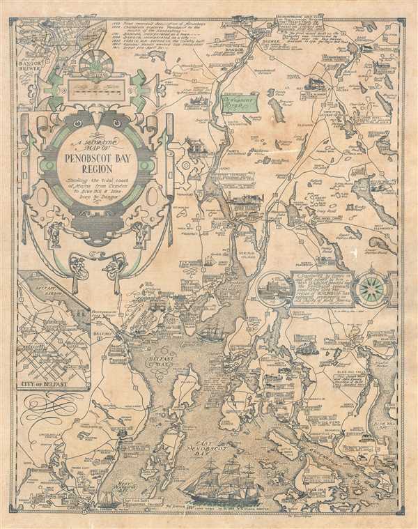
A Decorative Map of Penobscot Bay Region Showing the tidal coast of Maine from Camden to Blue Hill and Isles boro to Bangor.
1940 (dated) 20.5 x 16 in (52.07 x 40.64 cm) 1 : 330000
1940 (dated) 20.5 x 16 in (52.07 x 40.64 cm) 1 : 330000
Description
This is a 1940 Luther Savage Phillips pictorial map of Penobscot Bay, Maine. The map depicts the region from Hobbs Pond and Camp Merestead to Blue Hill Bay and from Bangor to Deer Isle. Sites throughout the region are illustrated in profile with their names inscribed on banners, including the Penobscot Marine Museum, the St. Regis Paper Company, Sunset Ridge Farm, Camp Roosevelt, and the Walter M. Hardy Orchard. Other regional sites are also identified, as are important highways, rivers, and islands. An inset to the right of center illustrates Fort Pownal and is situated next to a textbox that provides a short history of Penobscot Bay which reads, ‘Discovered by Gomes in 1525 and named by him ‘Baya Fermosa’ (beautiful bay), the Penobscot - generally associated with the region of Norumbega - has appeared prominently on old charts of North America.’ A short chronological history of the region is included as well, along the top border, near an inset map of 'Part of Bangor and Brewer', while a second insert, in the lower left quadrant, details the city of Belfast. Three sailing ships are depicted in Penobscot Bay, along with a lone sea monster.
Publication History and Census
This map was created and published by Luther Savage Phillips in 1940. An example is part of the David Rumsey Map Collection but it remains uncatalogued in the OCLC. This map is rare on the private market.Condition
Very good. Some spotting throughout. Overall toning. Minor loss and damage at places, repaired. Backed with archival paper.