This item has been sold, but you can get on the Waitlist to be notified if another example becomes available, or purchase a digital scan.
1944 Municipal Advertising Board City Map or Plan of Pensacola, Florida
Pensacola-municipal-1944$175.00

Title
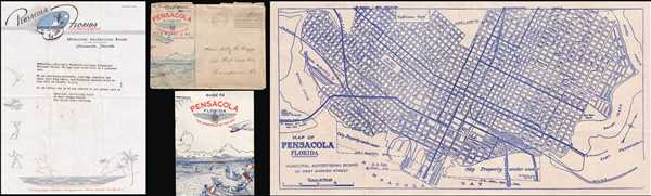
Map of Pensacola Florida.
1944 (undated) 10.5 x 21.25 in (26.67 x 53.975 cm) 1 : 15840
1944 (undated) 10.5 x 21.25 in (26.67 x 53.975 cm) 1 : 15840
Description
This is a 1944 Municipal Advertising Board city map or plan of Pensacola, Florida. The map depicts downtown Pensacola from Bayou-Chico to Bayou Texar and from Kupfrians Park to Pensacola Bay. Highly detailed, all the city's streets are labeled, as are several squares and places. The Frisco Railroad, the L and N Railroad, and the Pensacola, Mobile, and New Orleans Railroad are illustrated. Several docks, piers, and wharfs are noted along Pensacola Bay, including some that are serviced by the railroads.
This charming map is accompanied by the original 'Guide to Pensacola Florida' with which it was issued, a letter from the Municipal Advertising Board, and its original envelope. The envelope was sent by a lieutenant in the U.S. Navy Reserve from the Naval Air Station in Pensacola. This map and the accompanying ephemera were created by the Municipal Advertising Board in 1944.
This charming map is accompanied by the original 'Guide to Pensacola Florida' with which it was issued, a letter from the Municipal Advertising Board, and its original envelope. The envelope was sent by a lieutenant in the U.S. Navy Reserve from the Naval Air Station in Pensacola. This map and the accompanying ephemera were created by the Municipal Advertising Board in 1944.
Condition
Very good. Even overall toning. Accompanied by original envelope, tourism guide, and letter from the Municipal Advertising Office.