This item has been sold, but you can get on the Waitlist to be notified if another example becomes available, or purchase a digital scan.
1682 Stoopendaal Keur Map of Israel, Palestine or the Holy Land
PerigrinatiaeVeertich-keur-1682$500.00

Title
Perigrinatie ofte Veertich-Iarige Reyse der Kinderen Israels
1687 (undated) 12.5 x 18 in (31.75 x 45.72 cm)
1687 (undated) 12.5 x 18 in (31.75 x 45.72 cm)
Description
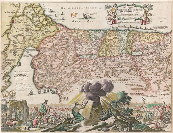
An absolutely stunning 1682 first state of Keur and Stoopendaal's map of the Holy Land, Israel, or Palestine. This map, from Keur's important Dutch Bible of 1687, is oriented to west and covers from the Nile Delta, Cairo and Memphis, egypt, across the Red Sea and along the Mediterranean Coast as far north as Sidon and Tyre (Lebanon), and further inland, Palmyra. Cartographically this map hails from the Nicholas Visscher map of 1650, but it does exhibit some modifications including completely revised topical imagery in the lower quadrants. Like Visscher's map, our map shows the course of the Israelites as they fled out of egypt, across the Red Sea, and subsequently spent the next forty years wandering in the Sinai before migrating into the Promised Land by crossing the Jordan River just north of the Dead Sea. Mt. Sinai, Mt. Horeb, Sodom, Gomorra, Jerusalem, and countless other importable Biblical locals are noted. In the Mediterranean a fleet of ships is transporting cedar from Sidon to Jaffa for the construction of Solomon's Temple. Also in the Mediterranean, there is an illustration Jonah being swallowed by the whale. These are the only two decorative elements that are inherited directly from Visscher's map of 1650. The elaborate decorative engraving work in the lower quadrants of the map is the work of Stoopendaal, a Dutch engraver active in Amsterdam during the late 17th and early 19th centuries. Stoopendaal's elaborate illustrations depicts various scenes from exodus including Moses receiving the Tables of Law, the encampments of the Israelites, Moses producing water from a stone, etc. This map was issued in many states by various publishers related to the Keur firm. The present example, bearing the 'H. Keur en M. Doornick' imprint, is the first state.
CartographerS
Daniel Stoopendaal (1672-1726) was a Dutch engraver and mapmaker active in Amsterdam during the early part of the17th century. Stoopendaal is best known for his garden and landscape prints. Cartographically D. Stoopendaal's most notable work is his re-engravings of Visscher maps of the Holy Land for inclusion in the Keur Bible. Daniel Stoopendaal is often confused with Bastiaan Stoopendaal, an engraver associated the Visscher firm, with whom he frequently work but was most likely not related. More by this mapmaker...
Claes Jansz Visscher (1587 - 1652) established the Visscher family publishing firm, which were prominent Dutch map publishers for nearly a century. The Visscher cartographic story beings with Claes Jansz Visscher who established the firm in Amsterdam near the offices of Pieter van den Keer and Jadocus Hondius. Many hypothesize that Visscher may have been one of Hondius's pupils and, under examination, this seems logical. The first Visscher maps appear around 1620 and include numerous individual maps as well as an atlas compiled of maps by various cartographers including Visscher himself. Upon the death of Claes, the firm fell into the hands of his son Nicholas Visscher I (1618 - 1679), who in 1677 received a privilege to publish from the States of Holland and West Friesland. The firm would in turn be passed on to his son, Nicholas Visscher II (1649 - 1702). Visscher II applied for his own privilege, receiving it in 1682. Most of the maps bearing the Visscher imprint were produced by these two men. Many Visscher maps also bear the imprint Piscator (a Latinized version of Visscher) and often feature the image of an elderly fisherman - an allusion to the family name. Upon the death of Nicholas Visscher II, the business was carried on by the widowed Elizabeth Verseyl Visscher (16?? - 1726). After her death, the firm and all of its plates was liquidated to Peter Schenk. Learn More...
Source
Biblia, (Amsterdam: Dordrecht, H., Keur, J., and Keur, P.) 1682.
Condition
Very good condition. Original fold lines.
References
Poorman, W. C. and Augusteijn, J., Kaarten in Bijbels (16e-18e eeuw), #140 (K-II-1). Laor, E., Maps of the Holy Land: Cartobibliography of Printed Maps, 1475-1900, #807.