This item has been sold, but you can get on the Waitlist to be notified if another example becomes available, or purchase a digital scan.
1658 De Wit Map of Persia, Arabia and the Near East
Persia-wit-1658-2$425.00

Title
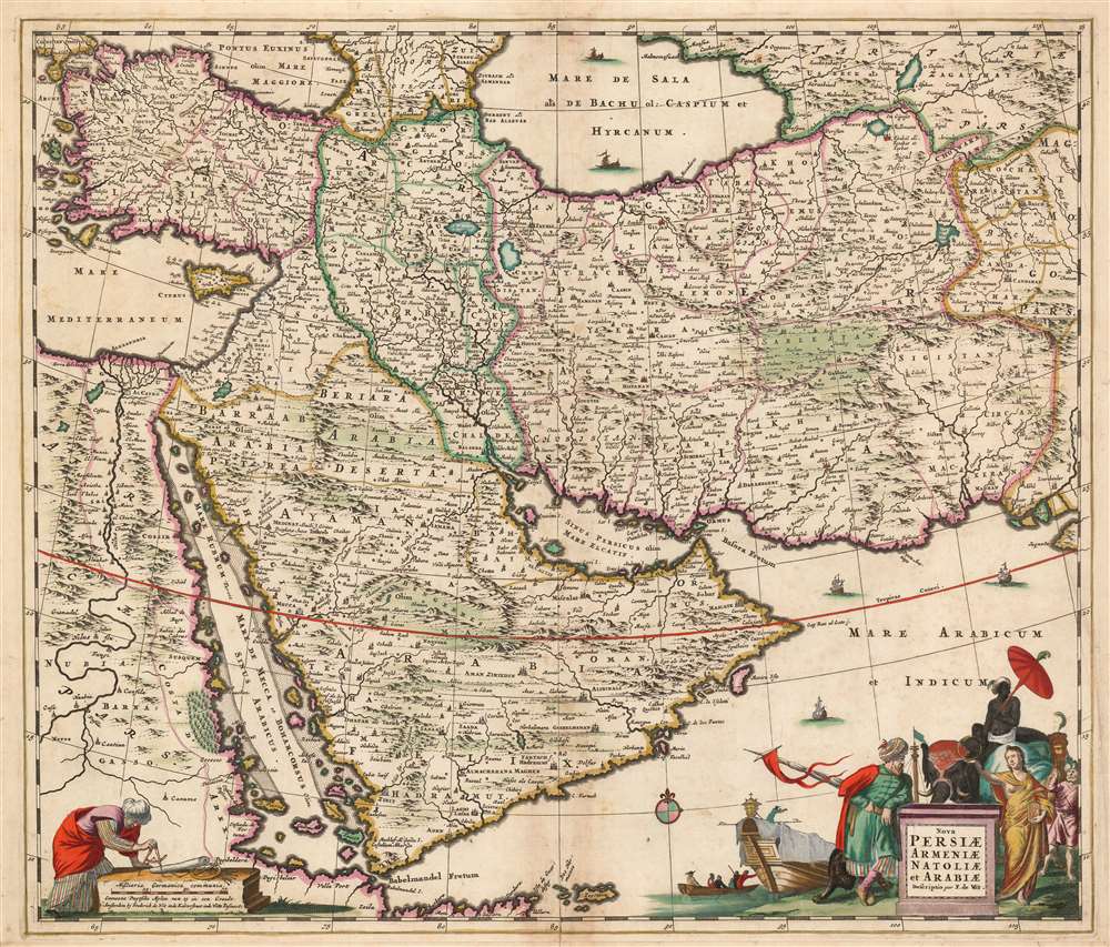
Nova Persiae Armeniae Natoliae et Arabiae Descriptio per F. de Wit.
1658 (undated) 18.5 x 22 in (46.99 x 55.88 cm) 1 : 9100000
1658 (undated) 18.5 x 22 in (46.99 x 55.88 cm) 1 : 9100000
Description
This beautifully engraved and colored map is Frederick de Wit's 1659 map of the Middle East. Tibbets described this map as 'the largest scale map of the area until 1700' and 'the most useful until D’Anville’s map of 1751'. Coverage extends from Constantinople and the Nile River Valley in the west, to the mouth of the Indus River in the east, and from the Black Sea and the Caspian Sea in the north to the southern tip of the Arabian Peninsula. It is centered on the Persian Empire but includes the whole of the Arabian Peninsula and Asia Minor. The Caspian Sea appears in a distorted, elongated shape which may have been a conflation of both the Caspian and the neighboring Aral Sea.
A Beautifully Engraved Cartouche
The map's cartouche contains the animal symbols associated with both Africa and Asia: a lion, a camel and an elephant. A merchant ship appears to be loading in the background. The elephant's rider, and the camel herder are in exotic garb. A figure representing the Turkish Sultan leans possessively on the title plinth. Opposite, a female allegorical figure displays an ouroboros and a clock: symbols of time, eternity really, and so her presence here is a reference to the ancient empires that occupied these territories.Publication History and Census
This map was engraved by Frederick de Wit, as early as 1659. It appeared in De Wit and Visscher atlases up through the 1680s. The plate was thereafter acquired by London mapmaker Christopher Browne, who added his own imprint to De Wit's. As early as 1700 the plate returned to Amsterdam, to be put in service by Peter Mortier, and it would remain in Covens and Mortier atlases appearing between 1710 and 1730. The present example, lacking any privilege, was certainly printed prior to 1688; the sharpness of the image suggests an early strike. In various editions this map is well represented in institutional collections.Cartographer
Frederik de Wit (1629 - 1706) was a Dutch Golden Age cartographer active in the second half of the 17th and the early 18th centuries. De Wit was born of middle class Protestant stock in the western Netherlandish town of Gouda. He relocated to Amsterdam sometime before 1648, where he worked under Willem Blaeu. His first attributed engraved map, a plan of Haarlem for Antonius Sanderus' Flandria Illustrata, was issued around this time. He struck out on his own in 1654. The first chart that De Wit personally both drew and engraved was most likely his 1659 map of Denmark, REGNI DANIÆ Accuratissima delineatio Perfeckte Kaerte van ‘t CONJNCKRYCK DENEMARCKEN. His great wall map of the world and most famous work, Nova Totius Terrarum Orbis Tabula appeared one year later. Following the publication of his wall map De Wit quickly rose in prominence as a both cartographer and engraver. He married Maria van der Way in 1661 and through her became a citizen of Amsterdam in 1662. Around this time he also published his first major atlas, a composite production ranging in size from 17 to over 150 maps and charts. Other atlases and individual maps followed. In 1689 De Wit was granted a 15 year Privilege by the Dutch States General. (An early copyright that protected the recipient's rights to print and publish.) He was recognized with the honorific 'Good Citizen' in 1694. De Wit died in 1706 after which his wife Maria continued publishing his maps until about 1710. De Wit's son, Franciscus, had no interest in the map trade, instead choosing to prosper as a stockfish merchant. On her own retirement, Maria sold most De Wit maps and plates at a public auction. Most were acquired by Pieter Mortier and laid the groundwork for the 1721 rise of Covens and Mortier, the largest Dutch cartographic publishing house of the 18th century. More by this mapmaker...
Condition
Very good. Margin extended at bottom, not impacting border. Several marginal mends; few filled wormholes. Superb original color. No verso text.
References
OCLC 605236764. Rumsey 12220.074 (1682) Tibbetts, G. Arabia in Early Maps 121. Alai, C. General Maps of Persia 1477-1925. E. 88.