This item has been sold, but you can get on the Waitlist to be notified if another example becomes available, or purchase a digital scan.
1867 Weyss Map of the Civil War Siege of Petersburg, Virginia
PetersburgFiveForks2-weyss-1867$187.50

Title
Petersburg and Five Forks.
1867 (dated) 22 x 34 in (55.88 x 86.36 cm) 1 : 42240
1867 (dated) 22 x 34 in (55.88 x 86.36 cm) 1 : 42240
Description
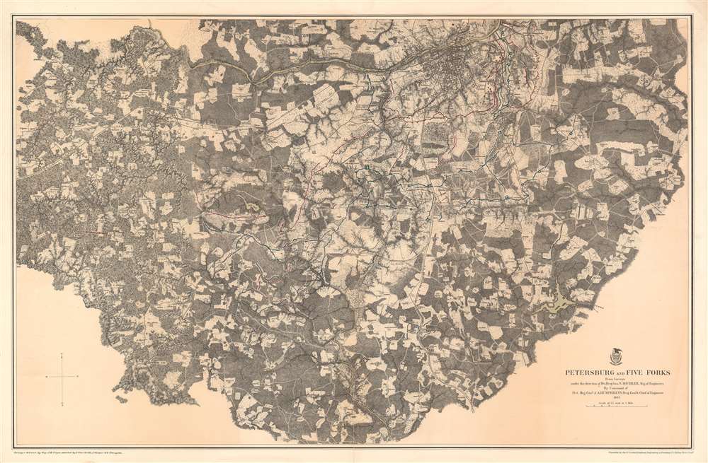
This is an 1867 John Weyss and Nathaniel Michler map of Petersburg and Five Forks, Virginia illustrating the Siege of Petersburg during the American Civil War (1862 - 1865). The map depicts the region from Five Forks to Prince George Court House and from the river road north of the Appomattox River to Malone's Bridge on Rowanty Creek.
The Siege of Petersburg and the American Civil War
The site of the climactic campaign of the American Civil War (but not the final battle), the city of Petersburg, Virginia is situated near the top border to the right of center. Concentric circles of Confederate and Union trenches are illustrated to the south and east of the city, though the lines stretch far to the south and west as well. A series of trenches and forts uncannily similar to those made infamous during the fighting on the Western Front in World War I, positions changed hands regularly, as General Ulysses S. Grant and the Union Army tried to force the Confederate soldiers into surrendering. Union troops made an effort to cut all supply lines into the city, which served as the principal supply hub for the Confederate capital of Richmond, Virginia, just over twenty miles to the north. Large battles and small skirmishes happened regularly, and Union forces bombarded Petersburg on a nearly daily basis. One such battle occurred on March 25, 1865, when Confederate troops attacked the Union position at Fort Stedman (illustrated here) east of Petersburg. The Confederates initially drove the Union troops from the fort and three adjacent batteries, but the Union army immediately counterattacked and sent the Confederates retreating back into Petersburg.The Battle of Five Forks
The Battle of Five Forks took place on April 1, 1865, at the end of the Siege of Petersburg and within days of the end of the American Civil War. Union cavalry commanded by Major General Philip Sheridan attacked and defeated a Confederate force led by Major General George Pickett. This victory seized the vital intersection at Five Forks, which was key to controlling the South Side Railroad, an important supply and evacuation route from Richmond, where the Confederate government was entrenched. This victory directly led to Confederate General Robert E. Lee's decision to abandon Richmond and Petersburg and retreat west, in an attempt to make contact with General Joseph Johnston's army in North Carolina, making the Union victory at Five Forks a critical step toward forcing the surrender of Lee and the Army of Northern Virginia eight days later at Appomattox Court House.Publication History and Census
This map was surveyed and drawn by Major John E. Weyss under the command of Nathaniel Michler, engraved by Julius Bien, and published by the War Department in Military Maps illustrating the Operations of the Armies of the Potomac and James in 1869. While this map is well represented in institutional collections, it is rare on the private market.CartographerS
John E. Weyss (1820 - June 24, 1903) was an Austrian-American illustrator, cartographer, and engineer. Born in Vienna, Weyss immigrated to the United States in 1848 and settled in New York. He served as a member of the U.S. Government's Mexican Boundary Survey (1849 - 1855), led by Major William Hemsley Emory, because of his training as an illustrator. In the capacity of a civilian artist working for the army, Weyss contributed several illustrations for Emory's report, which was published in 1857-59. Weyss is also credited on eleven of the report's maps. At the outbreak of the American Civil War, Weyss held a position as a civil engineer for the state of Kentucky. Weyss received a commission as a major from the Governor of Kentucky and, due to his professional experience, was assigned to the staff of Captain Nathaniel Michler, the chief topographical officer in the Army of the Ohio. In this role he did survey work for maps of the vicinity of Shiloh and Corinth, both sites of major Civil War battles. Weyss then joined Captain Michler when he moved to the staff of General Rosecrans in late 1862, for whom they made a series of maps of the Battle of Stones River. Weyss and Michler were then transferred to the Army of the Potomac in May, 1863. One of Weyss's first assignments for the Army of the Potomac was a map of the vicinity of Harper's Ferry, Virginia, for which he produced a highly detailed map of the very complex topography of the region. Soon, Weyss was made responsible for the day-to-day detailed mapping during the siege at Petersburg. After the war, Weyss served as the principal surveyor under the direction of Michler during the creation of the atlas Military maps illustrating the operations of the armies of the Potomac and James, May 4th 1864 to April 9th 1865, that was published in 1869. Weyss served the U.S. Army Corps of Engineers for another twenty years, until he retired sometime in the 1880s. Weyss died on June 4, 1903, in Washington, D.C. More by this mapmaker...
Nathaniel Michler (September 13, 1827 - July 17, 1881) was an American military officer and mapmaker who served during the American Civil War. Born in Easton, Pennsylvania, Michler attended West Point, from which he graduated seventh in his class. Commissioned as a 2nd Lieutenant in the Topographical Engineers, Michler participated in the Mexican Boundary Survey from 1851 until 1857, when he was transferred to serve as the chief topographical engineer in surveys for a proposed canal from the Gulf of Darien to the Pacific Ocean from 1858 until 1860. He held the rank of Captain at the outbreak of the American Civil War and served with the Army of the Cumberland from 1861 - 1863, then was transferred to the Army of the Potomac and built defensive works for the Union Army at the Battles of the Wilderness, Spotsylvania, Cold Harbor, and Petersburg. He was promoted to Colonel in August 1864 and brevetted Brigadier General in April 1865. After the war, Michler served as superintendent in the District of Columbia until 1871 and from 1872 to 1875 was chief engineer with the General Commanding Division of the Pacific. He acted as military attaché for the United States Legation in Vienna, Austria from 1878 to 1880. Learn More...
Julius (Julien) Bien (September 27, 1826 - December 21, 1909) was a German-Jewish lithographer and engraver based in New York City. Bien was born in Naumburg, Germany. He was educated at the Academy of Fine Arts, Cassell and at Städel's Institute, Frankfurt-am-Main. Following the suppression of the anti-autocratic German Revolutions of 1848, Bien, who participated in the pan-German movement, found himself out of favor in his home country and joined the mass German immigration to the United States. Bien can be found in New York as early as 1849. He established the New York Lithographing, Engraving & Printing Company in New York that focused on the emergent chromo-lithograph process - a method of printing color using lithographic plates. His work drew the attention of the U.S. Government Printing Office which contracted him to produce countless government maps and surveys, including the Pacific Railroad Surveys, the census, numerous coast surveys, and various maps relating to the American Civil War. Bien also issued several atlases both privately and in conjunction with a relation, Joseph Bien. At the height of his career Bien was elected president of the American Lithographers Association. After his death in 1909, Bien's firm was taken over by his son who promptly ran it into insolvency. The firm was sold to Sheldon Franklin, who, as part of the deal, retained the right to publish under the Julius Bien imprint. In addition to his work as a printer, Bien was active in the New York German Jewish community. He was director of the New York Hebrew Technical Institute, the New York Hebrew Orphan Asylum, and president of the B'nai B'rith Order. Learn More...
Source
War Department, Military Maps illustrating the Operations of the Armies of the Potomac and James May 4th 1864 to April 9th 1865 including Battlefields of the Wilderness, Spottsylvania, Northanna, Totopotomoy, Cold Harbor, The Siege of Petersburg and Richmond Battlefields of Five Forks, Jetersville and Sailor's Creek, Highbridge, Farmville, and Appomattox Court-House. (Washington) 1869.
Military Maps Illustrating the Operations of the Armies of the Potomac and James, published in 1869, compiled all the maps created by Major Nathaniel Michler and Major John E. Weyss of all the major battlefields of the eastern theater of war during the American Civil War. These maps blended together surveys done by soldiers both before and during battles and work done by Weiss and his team of engineers after the war was over. Many of these maps were reduced in order to be republished in the Atlas to Accompany the Official Records of the Union and Confederate Armies, which has become the standard reference for Civil War military maps.
Condition
Very good. Toning along original centerfold. Centerfold separations professionally repaired on verso. Closed margin tears professionally repaired on verso. Closed tear extending one half inch into printed area from right margin professionally repaired on verso. Blank on verso.
References
Rumsey 3881.011. OCLC 56794787.