1896 E.P. Noll Cycling Map of Philadelphia, Pennsylvania, and Vicinity
PhiladelphiaSurrounding-noll-1896$400.00

Title
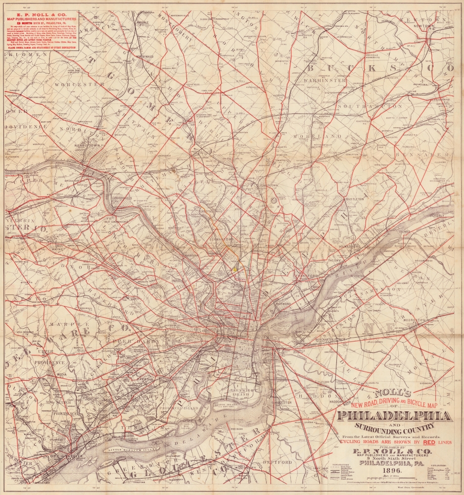
Noll's New Road, Driving and Bicycle Map of Philadelphia and Surrounding Country.
1896 (dated) 31 x 29 in (78.74 x 73.66 cm) 1 : 63360
1896 (dated) 31 x 29 in (78.74 x 73.66 cm) 1 : 63360
Description
This is a visually compelling 1896 E.P. Noll and Company map of Philadelphia and environs. The map was published to capitalize on the late 19th century Philadelphia cycling craze at its apex. Being reasonably level, Philadelphia was perfect for cycling and maps such as this opened the greater region to velocipedic exploration.
A year after this map's publication, a national cycling organization known as the League of American Wheelmen hosted an event in Philadelphia and 45,000 cyclists attended. During the 1890s, when cycling was immensely popular in Philadelphia, publications such as the Philadelphia Inquirer published maps of cycling routes from 1896 to 1898 in a column titled, 'Trips Awheel: Where to Go and How to Get There'.
A Closer Look
With Philadelphia at center, the map depicts the region from Fortuna south to Woodbury and from Centreville to Langhorne. Red overprinting highlights cycling roads throughout, emphasizing the popularity of this emerging new pastime. Other roads, railroads, rivers, and creeks appear as well. Towns, villages, train stations, and post offices are identified throughout.The Bicycle Boom
Although invented in the early 19th century, bicycles only became commercially accessible and popular in the closing decades of the 19th century. A range of innovations made the machines more reliable, safe, comfortable, and affordable, and they became fashionable for their applications in transportation, leisure, and sport. As would later happen with automobiles, cycling clubs sprang up to scour best routes, advocate for improved roads, and connect enthusiasts (for instance, the Massachusetts Bicycle Club was founded in 1879 in Boston). Cycling was particularly popular among women, as it provided freedom of movement and association (the sexes could intermingle without parental oversight).Cycling in Philadelphia
Philadelphia was one of the centers of the Cycling Craze in the United States, with cycling clubs springing up throughout the city. These clubs even built elaborate clubhouses, including that of the Quaker City Wheelmen, which still stands. The Wheelmen organized and hosted national meets, dances, and free public cycling events, and even attempted to print their own magazine, Cycling. The Quaker City Wheelmen reappeared in 1976 and still exist as 'QCW Cycling'.A year after this map's publication, a national cycling organization known as the League of American Wheelmen hosted an event in Philadelphia and 45,000 cyclists attended. During the 1890s, when cycling was immensely popular in Philadelphia, publications such as the Philadelphia Inquirer published maps of cycling routes from 1896 to 1898 in a column titled, 'Trips Awheel: Where to Go and How to Get There'.
Publication History and Census
This map was created and published by E. P. Noll and Company in 1896. We note a single cataloged example, located at the University of California Davis.Cartographer
Edward. P. Noll (1855 - March 28, 1926) was an American map publisher who owned a firm operating in Philadelphia; his work appeared prolifically in the last quarter of the 19th century and the first years of the 20th. E. P. Noll and Company was a leading firm of the period, specializing in maps for bicyclists, motorists, and other travelers. He was born in Kentucky to German parents. The family moved to Cincinnati, where his father Peter Franz became a saloon keeper. Nothing is known of Edward’s early education, though by 1880 the family had moved to Philadelphia: that year’s census lists Peter Franz as a brewer, and Edward as a ‘map moulder.’ More by this mapmaker...
Condition
Good. Wear and toning along original fold lines. Verso repairs and reinforcements at fold intersections. Slight loss at fold intersections.
References
OCLC 381174948.