This item has been sold, but you can get on the Waitlist to be notified if another example becomes available, or purchase a digital scan.
1941 Imperial Japanese Survey WWII Map of the Philippines (before invasion)
Philippines-japanesesurvey-1941-2$600.00

Title
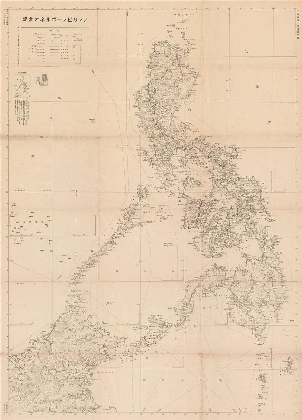
The Philippines - Northern Borneo. / フィリピンーボルネオ北部
1941 (dated) 42.25 x 30 in (107.315 x 76.2 cm) 1 : 3000000
1941 (dated) 42.25 x 30 in (107.315 x 76.2 cm) 1 : 3000000
Description
A rare large-format 1941 Japanese General Staff Headquarters (参謀本部) World War II aviation map of the Philippines and Northern Borneo issued just months before the December 7, 1941 Japanese invasion. It offers critical insight into not only Japan's attack plan, but also its ambitious long-term goals for the Philippines.
A Closer Look
Cartographically, the map's focus is on topography and transportation networks, noting roads, railroad routes, and shipping lanes while at the same time emphasizing the archipelago's rugged topography. The focus of the map is on aviation - which is why, other than transportation networks, the map is minimalist.The Japanese Strategy in the Philippines
The capture and control of the Philippines was vital to the success of Japanese plans to dominate the Pacific. Not only was the archipelago rich in natural resources, including rubber, oil, mineral resources, and wood, it was also centrally located and well positioned for expansion into the East Indies. Moreover, wresting control of the Philippines from the United States would have effectively undermined the American ability to wage war in the region. The Japanese invasion of the Philippines commenced on December 8, 1941, one day after the December 7th, 1941 bombing of Pearl Harbor. While Japanese forces advanced quickly through the archipelago, like the Spanish before them, they promptly discovered that the hundreds of islands and limited infrastructure made the Philippines almost impossible to fully control. Nonetheless, the Japanese maintained a tenuous control of most of the Philippine Islands until 1944, when the U.S. led Allied Forces began an aggressive and bloody campaign to retake the islands. Allied forces successfully drove the Japanese out of the Philippines in 1945.Publication History and Census
This rare map of the was issued by the General Staff Headquarters (参謀本部) of the Japanese Imperial Land Survey Office (陸地測量部) on August 16, Showa 16, or 1941. We are aware of just one other example.Cartographer
Japanese Imperial Land Survey (陸地測量部; 1888 - present) was a Japanese governmental mapping agency established in 1888 to map the home islands. By 1925 the Land Survey had completed a 1: 50000 scale map of the home islands. Then expansionist, the Imperial Japanese were keenly aware that, like railroads, telegraphs, and guns, maps were tools of empire indispensable to governance, surveillance, commerce, and countless other imperial initiatives, the very lifeblood the state. As Japan expanded into Korea, Taiwan, the Philippines, and elsewhere, imperial cartographers followed closely behind imperial soldiers. Their work was of the highest caliber and incorporated the most modern and sophisticated survey techniques - resulting in mappings that exceeded all previous work in their respective regions for both thoroughness and accuracy. After World War II, the Japanese Imperial Land Survey was folded into civic administration, but still functions as part of the Japanese government. More by this mapmaker...
Condition
Good. Overall toning. Some spotting and verso reinforcement. Wear on old fold lines.