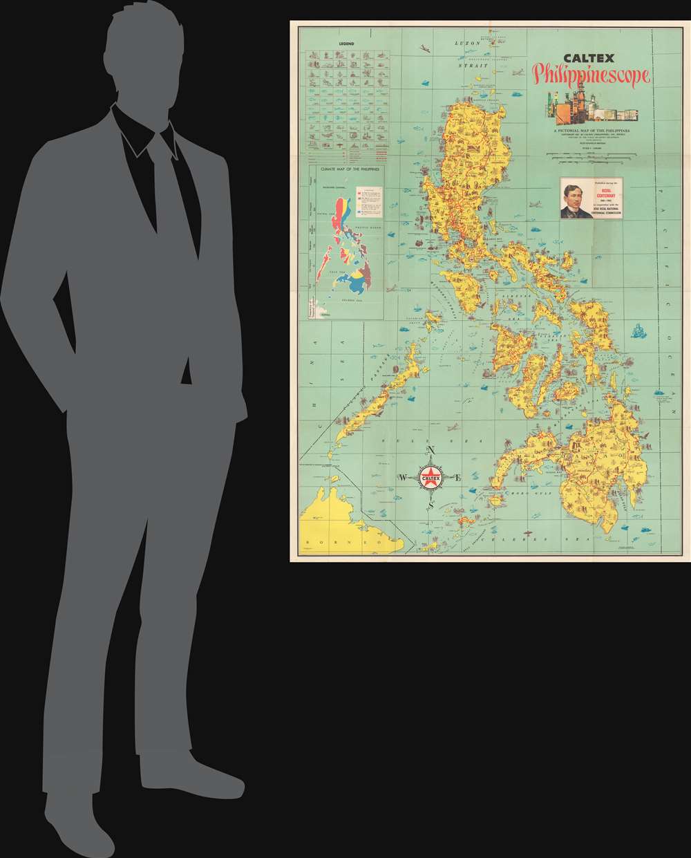
1961 Caltex 'Philippinescope' Pictorial Map of the Philippines
Philippinescope-caltex-1961$950.00


Title
Caltex Philippinescope. A Pictorial Map of the Philippines.
1961 (dated) 42.5 x 32.25 in (107.95 x 81.915 cm) 1 : 1600000
1961 (dated) 42.5 x 32.25 in (107.95 x 81.915 cm) 1 : 1600000
Description
A striking large-scale pictorial map of the Philippines issued for Caltex in conjunction with the Jose Rizal Centennial (1861 - 1961).
A Closer Look
The map covers all of the Philippines and is overlaid with various vignette-style symbols keyed to a legend in the upper left. Most represent natural resources, from petroleum, mineral wealth, and agriculture to rich fisheries. Other symbols represent historical events, most of which feature interesting annotations. A submap details climate variation. An inset below the title celebrates José Rizal and is unique to the 5th printing.José Rizal
José Protasio Rizal Mercado y Alonso Realonda (1861 - 1896) was a Filipino nationalist and polymath active in the Spanish colonial Philippines. He is considered a national hero for his influence on the Philippine independence movement. An ophthalmologist by profession, Rizal contributed to the Filipino Propaganda Movement, which advocated for pro-Filipino political reforms but not necessarily independence. He was implicated in activities leading up to the Philippine Revolution (1896 - 1898), which, although inspired in part by his writing, he did not participate in. Nonetheless, after the Revolution was suppressed, he was executed by the Spanish colonial government. Although Rizal was not actively Revolutionary, he ultimately approved of the movement for Philippine independence.Publication History and Census
The artwork was prepared by A. Garcia Promotions. It was printed in Manila by Capitol Publishing for Caltex Philippines. The present example is the 5th printing, 1961, with revised content celebrating the José Rizal Centennial (1861 - 1961). We note three examples in the OCLC, all at the National Library of Australia, representing the 1956 4th edition, by 'Cacho Hnos., Inc.'., 5th edition (as here), and 9th edition. A third example appears in the collections of the Vancouver Public Library Britannia. There may be as many as 9 total printings, with the last printing in 1968. We have not identified any surviving examples of the 1-3rd or 6th - 8th printings.Cartographer
Capitol Publishing (1947 - Present) is a Philippine publishing house based in Manila. The firm was founded in 1947 and remains active today. More by this mapmaker...
Condition
Very good. Slight wear on old fold lines.
References
National Library of Australia, 1957821. Vancouver Public Library, 912.599 C16c.