1960 French Pictorial Map of Phnom Penh, Cambodia
PhnomPenh-french-1960$1,200.00

Title
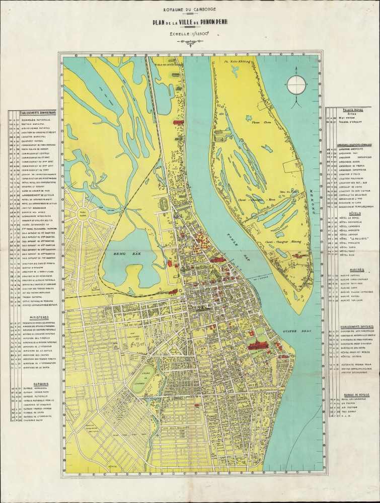
Plan de la Ville de Phnom Penh.
1960 (undated) 30.25 x 22 in (76.835 x 55.88 cm) 1 : 12000
1960 (undated) 30.25 x 22 in (76.835 x 55.88 cm) 1 : 12000
Description
A rare c. 1960 map of Phnom Penh, capital of Cambodia, during the Sangkum Period when it was known as the ‘Pearl of Asia’. The map represents the final days of a golden era of development for Phnom Penh, as major urban projects, canals, and dredging efforts drained the swampy flood plain. It also includes the initial layout and planning of the elite Khan Toul Kouk neighborhood.
A Closer Look
The map is based on an earlier map first published in the 1930s under French colonial auspices - with significant updates and revisions to the date of publication. It covers the city from the Mekong to Beng Kâk and the Phnom Penh - Poipet Railway. New planned neighborhoods and widespread urbanization then under development are defined by ghosted-in street grids. The map is surrounded by a street and building index, and important structures are illustrated pictorially.The Belle Époque of Phnom-Penh
Phnom Penh was established as the capital of Cambodia in 1865 by King Norodom I (1860 - 1904). At the time, it was a waterlogged flood plain described by the 19th century historian Penny Edwards as ‘best known for its vast tracts of mosquito-infested swampland, the stench of stagnant water and human waste, and frequent outbreaks of cholera’. The French established a protectorate in Cambodia in the 1870s and began to remake the city as a grand colonial capital in the spirit of Saigon or Hanoi. Land reclamation efforts along the Tonle Sap River led to the construction of a Grand Canal, located roughly between avenues 106 (Avenue Verneville) and 108 (Avenue Piquet). This was followed by a railroad in the 1920s, and the dredging and gridding of the region to the south of 108th Avenue (Avenue Piquet). The Grand Canal was filled and replaced with broad avenues and a park (Freedom Park) in the 1920s. The Phnom Penh Railway Station - shown here - was completed in 1932 at the western end of Freedom Park. Likewise, the impressive Psar Themy or New Market was built in a grandiose domed style using a then innovative material - reinforced concrete. The Japanese invaded Cambodia in 1941, stationing troops in Phnom Penh, ending the French Era. At the end of WWII (1939 - 1945), King Norodom Sihanouk declared the independent Kingdom of Kampuchea, although it took another 8 years before the French colonial administrators recognized the claim. This began the Sangkum Period, which was characterized by oddly fused monarchist and socialist values. Discontent with Sihanouk's governance and widespread corruption led to the more radicalized communism of Pol Pot by the mid 1960s.Publication History and Census
The map is undated, and no publisher is named. It is however derived from an earlier variant published in the 1920s-30s under the French colonial administration. The present state, judging from the widespread urbanization, we can loosely date the map to about 1960 - during the Sangkum Period. There are no other known examples.Condition
Very good. Slight soiling and wear on old fold lines.