1967 French Pictorial Map of Phnom Penh
PhnomPenh-unknown-1967$400.00

Title
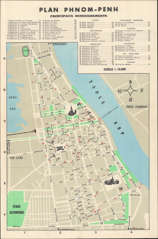
Plan Phnom-Penh.
1967 (undated) 17 x 11 in (43.18 x 27.94 cm) 1 : 10000
1967 (undated) 17 x 11 in (43.18 x 27.94 cm) 1 : 10000
Description
A scarce c. 1967 French-language city map of Phnom-Penh, Cambodia. It depicts the city towards the end of the Sihanouk era, before a military coup in 1970 that brought a U.S.-aligned military government to power, which was soon overthrown by the Khmer Rouge.
The Japanese invaded Cambodia in 1941, stationing troops in Phnom Penh, ending the French Era. At the end of World War II (1939 - 1945), King Norodom Sihanouk declared the independent Kingdom of Kampuchea, although it took another eight years before the French colonial administrators recognized the claim. This began the Sangkum Period, which was characterized by oddly fused monarchist and socialist values, including alignment with other Asian socialist and communist movements. Discontent with Sihanouk's governance and widespread corruption led to the more radicalized communism of Pol Pot to establish itself in rural areas by the mid-1960s. At the same time, the military aligned closely with the United States and South Vietnam, overthrowing Sihanouk in 1970, before themselves being ousted by the Khmer Rouge five years later. Under the Khmer Rouge, Phnom Penh, which had grown rapidly with the influx of refugees from rural areas, was mostly depopulated, and the city's former residents, who were deemed politically unreliable, suffered tremendously, with hundreds of thousands being murdered or dying from mistreatment and starvation.
A Closer Look
The center of the city along the Tonle Sap is displayed with roads named and the location of 59 sites indicated, corresponding to an index at top. The marked sites include government offices, schools, museums, major hotels and restaurants, embassies, banks, airline offices, pharmacies and medical offices, and a club called 'Dancing Mékong'. Three landmarks are represented pictorially but not labeled - the pagoda of Wat Phnom towards the top, the X-shaped Central Market at left, and the Cambodian Royal Palace at bottom-right.Cambodia's Olympic Stadium
The Olympic Stadium at bottom-left was built in 1964 with high aspirations and was one of the largest stadiums in Asia when completed, containing not only a grass field but also indoor facilities including Olympic-sized swimming pools. However, its use was limited due to political instability and warfare. The stadium did host the 1966 GANEFO (Games of New Emerging Forces) Games, meant as an alternative to the Olympics, which were deemed too colonialist / imperialist for not including several Communist, anti-colonial countries. Similarly, in 1965 it hosted a two FIFA World Cup qualifying matches between North Korea and Australia which was similarly due to the lack of diplomatic recognition for North Korea's government by Western countries. Under the Khmer Rouge, the stadium was used as an execution ground for officials of the Khmer Republic government, which overthrew Sihanouk in 1970 and aligned closely with the United States and South Vietnam. The stadium was remodeled in 2000 and still stands, recently hosting the 2023 Southeast Asian Games.The 'Pearl of Asia' and Its Destruction
Phnom Penh was established as the capital of Cambodia in 1865 by King Norodom I (1860 - 1904). At the time, it was a waterlogged flood plain described by the 19th century historian Penny Edwards as 'best known for its vast tracts of mosquito-infested swampland, the stench of stagnant water and human waste, and frequent outbreaks of cholera'. The French established a protectorate in Cambodia in the 1870s and began to remake the city as a grand colonial capital in the spirit of Saigon or Hanoi, investing in a network of new avenues, parks, canals, markets, and railways.The Japanese invaded Cambodia in 1941, stationing troops in Phnom Penh, ending the French Era. At the end of World War II (1939 - 1945), King Norodom Sihanouk declared the independent Kingdom of Kampuchea, although it took another eight years before the French colonial administrators recognized the claim. This began the Sangkum Period, which was characterized by oddly fused monarchist and socialist values, including alignment with other Asian socialist and communist movements. Discontent with Sihanouk's governance and widespread corruption led to the more radicalized communism of Pol Pot to establish itself in rural areas by the mid-1960s. At the same time, the military aligned closely with the United States and South Vietnam, overthrowing Sihanouk in 1970, before themselves being ousted by the Khmer Rouge five years later. Under the Khmer Rouge, Phnom Penh, which had grown rapidly with the influx of refugees from rural areas, was mostly depopulated, and the city's former residents, who were deemed politically unreliable, suffered tremendously, with hundreds of thousands being murdered or dying from mistreatment and starvation.
Publication History and Census
This map was produced by an unknown maker. It is undated, but from context looks to date from the late 1960s. The only map in institutional collections which appears to match it is held by the Staatsbibliothek zu Berlin and is dated c. 1967.Condition
Very good. Light soiling. Light wear along original folds.
References
OCLC 837497670.