This item has been sold, but you can get on the Waitlist to be notified if another example becomes available, or purchase a digital scan.
1944 64th Engineer Topo. Bn. Photomap of Iwo Jima and Mt. Suribachi
PhotoMapMtSuribachi-64thengr-1944$1,000.00

Title
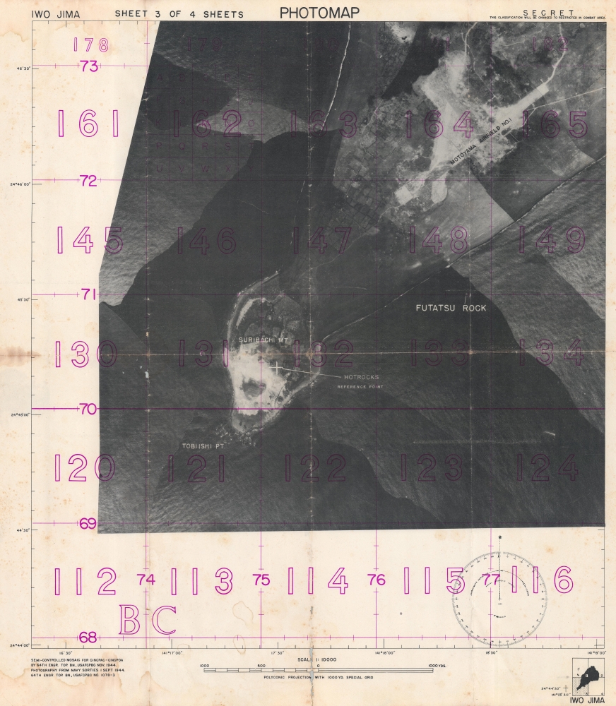
Photomap. Iwo Jima. Sheet 3 of 4 Sheets.
1944 (dated) 22.25 x 19 in (56.515 x 48.26 cm) 1 : 10000
1944 (dated) 22.25 x 19 in (56.515 x 48.26 cm) 1 : 10000
Description
This is a 1944 64th Engineer Topographic Battalion photomap of Iwo Jima illustrating Mount Suribachi and Airfield No. 1 - the critical objectives of the Iwo Jima invasion. Few photographic maps have survived from Pacific invasions - this being thus a remarkable discovery. Photographic mapmaking was pioneered during World War II, particularly in the Pacific, where strategically critical battles were fought over tiny volcanic islands and atolls that were previously cartographically ignored. Engineer topographic battalions compiled aerial photography (as here), ship-side triangulation, older maps, and shipboard printed to produce on-the-spot yet highly accurate field maps.
A Closer Look
Marked 'SECRET' in the upper right corner, Mount Suribachi appears in the lower left while the airfield occupies part of the upper right. The purple grid overlay utilizes the same number system as other maps of Iwo Jima produced for the invasion (see: iwojima-usnavy-1944). Both Airfield No. 1 and Mount Suribachi were crucial objectives for the Marines during the first day of the battle. Mount Suribachi proved a difficult objective, since the Japanese had tunneled extensively into the mountain creating a strongly fortified position.The Battle of Iwo Jima
The Battle of Iwo Jima (February 19 - March 26, 1945) was an American invasion of the Pacific island of Iwo Jima. One of the Japanese volcano Islands, Iwo Jima is 750 miles south of Tokyo. It was set up as a Japanese airbase during WWII. Over the course of the thirty-six-day battle, American forces suffered over 27,000 casualties. Of the approximately 20,000 Japanese soldiers defending the island, only 216 were taken prisoner. Iwo Jima is still remembered for its brutality and heavy toll. Since the battle, the island's significance as a strategic asset has become disputed. In April 1945, less than a month after the end of the battle, retired Chief of Naval Operations William V. Pratt was quoted in NewsweekThe expenditure of manpower to acquire a small, God-forsaken island, useless to the Army as a staging base and useless to the Navy as a fleet base … [one] wonders if the same sort of airbase could not have been reached by acquiring other strategic localities at lower cost'.The iconic Joe Rosenthal of six Marines raising the U.S. flag at the top of Mount Suribachi, which subsequently became the U.S. Marine Corps War Memorial, is perhaps the most recognizable record of the battle.
Engineer Topographic Battalions during World War II
After World War II erupted in Europe, U.S. military officials realized that currently available maps were inadequate for modern artillery units or even tactical purposes. Their solution was the creation of engineer topographic battalions. Engineer Topographic Battalions provided technical support for the U.S. Army in the form of surveying, drafting, and printing maps for units on the ground. During the war, these battalions were responsible for creating accurate four-color topographic maps, along with surveying, printing, and distribution of these maps.Publication History and Census
This map was created by the 64th Engineer Topographic Battalion in November 1944. We have been unable to locate any cataloged separate examples of Sheet 3. Complete sets with sheets 1-4 are part of the collections at the National Archives and the University of California Los Angeles.Condition
Good. Soiling. Wear and toning along fold lines. Slight loss to photomap between grids 130 and 131. Loss along fold line below map effecting scale and 'N' in 'Projection'.