
This item below is out of stock, but another example (left) is available. To view the available item, click "Details."
Details
1823 Vandermeren City Map or Plan of Rome, Italy
1823 (undated) $500.00
1852 Joseph Manz Map of Ancient and Modern Rome (w/ Vatican City)
PiantaRomaAntica-manz-1852$125.00

Title
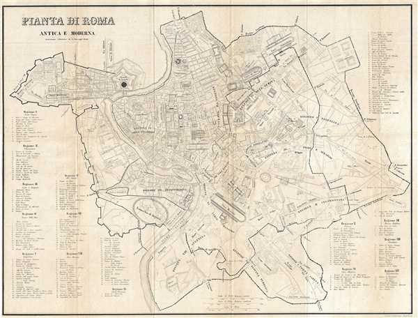
Pianta di Roma Antica E Moderna.
1852 (undated) 16 x 21 in (40.64 x 53.34 cm) 1 : 11500
1852 (undated) 16 x 21 in (40.64 x 53.34 cm) 1 : 11500
Description
This is a beautiful c.1852 map depicting the city of Rome during ancient and modern times. Covers the entire city of Rome including the Vatican. Known as the birthplace of western civilization, Rome was the capital of the Roman Empire. The ancient city is noted within the Wall of Aurelian and Honorius and the Wall of Servius Tullius (The Servian Wall). The map depicts the city in extraordinary detail labeling important ancient roads and sites as well we historic buildings such as the Pantheon, the baths of Antoninus, the Coliseum, part of the baths of Titus, and others. A key along the borders lists the 14 regions of ancient Rome and identifies the important locations marked on the map within each region. The map was issued by Joseph Manz and engraved by Niedermayr, Rugensburg.
Condition
Very good. Minor wear along original fold lines. Minor toning and foxing.