1931 Medina Pictorial Map of Mexico
PictorialMexico-miguelgomezmedina-1931$350.00

Title
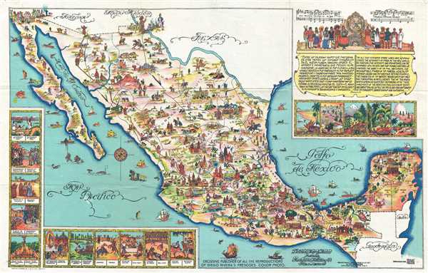
Pictorial Map of Mexico.
1931 (undated) 12.5 x 20 in (31.75 x 50.8 cm) 1 : 6190000
1931 (undated) 12.5 x 20 in (31.75 x 50.8 cm) 1 : 6190000
Description
This is a 1931 Miguel Gomez Medina pictorial map of Mexico. The map depicts all of Mexico from the southern United States (labeling Arizona, New Mexico, and Texas) to the Belize, Guatemala, and the Pacific Ocean and from the Pacific Ocean and Baja California to the Gulf of Mexico. Wonderfully composed, countless tiny cartoon vignettes illustrate Mexican life, history, and culture. Numerous cities are labeled, including Mexico City, Chihuahua, Oaxaca, Ciudad Juarez, and Tijuana, among others. The modern tourist haven of Cozumel Island is also illustrated. Chichén Itzá, the astounding Mayan ruin in the Yucatan is illustrated in profile. At the U.S.-Mexico border, Uncle Sam appears El Paso, Texas, on one end of a bridge a bridge, while a good natured Mexican citizen offers what is possibly a bottle of tequila, from the Mexican side of the river. In the ocean, numerous fish and other sea creatures are illustrated, along with various ships.
Several vignettes are situated along the left and bottom border, illustrating aspects of Mexican history and culture. Each of the vignettes is captioned in both Spanish and English and features scenes of the founding of Mexico, the conquest of Mexico by Cortes, Mexican independence, and cultural events such as a rodeo, a bull-fight, and the national dance. A cartouche in the upper right corner contains a quote from William Prescott stating the splendor and unequaled importance of Mexico to the Spanish empire. Below the quote are five beautifully drawn landscapes.
This map was created in 1931 by Miguel Gomez Medina, the best known Mexican artist creating pictorial maps, and published by Fischgrund Publishing Company. There are at least two editions of this map, the present medium format example, and another larger format edition.
CartographerS
Miguel Gómez Medina (fl. c. 1930 – 1960) was a Mexican illustrator and graphic artist active in the first half of the 20th century to about 1960. Gomez is the most significant Mexican proponent of the Golden Age of Pictorial Mapmaking (c. 1920 – 1960) with several significant large format pictorial maps of various parts of Mexico and Guatemala to his name. Medina was a versatile artist capable of work in a variety of different styles, with some of his work being akin to English pictorial map pioneer MacDonald Gill and other pieces reminiscent of the French illustrator Lucian Boucher. In addition to large format poster maps, Medina also issued map postcards, including one of Guatemala and another of Canada. Medina's maps and postcards were typically published by Athenaeum Fischgrund Publishing. Little is known of Medina's personal life. More by this mapmaker...
Eugenio Fischgrund (1905 - 1980) was a travel writer and publisher of posters, books and postcards active in Mexico City. Fischgrund owned several imprints, including Athenaeum Fischgrund Publishing, which he founded c. 1930, and Editorial de Arte. He was also one of the first to publish and distribute prints of works by Mexican artists in the United States. Some of his artists included Diego Riviera (1886 – 1957), Charles X. Carlson (1902–1991), F. Lugo, Rafael Martínez Padilla (1878–1958), and Miguel Gomez Medina. Learn More...
Condition
Very good. Verso repair of a fold separation. Blank on verso.
References
Rumsey 8747.000.