This item has been sold, but you can get on the Waitlist to be notified if another example becomes available, or purchase a digital scan.
1933 Moody and Missouri State Highway Commission Pictorial Map of Missouri
PictorialMissouri-highwaycommission-1933$75.00

Title
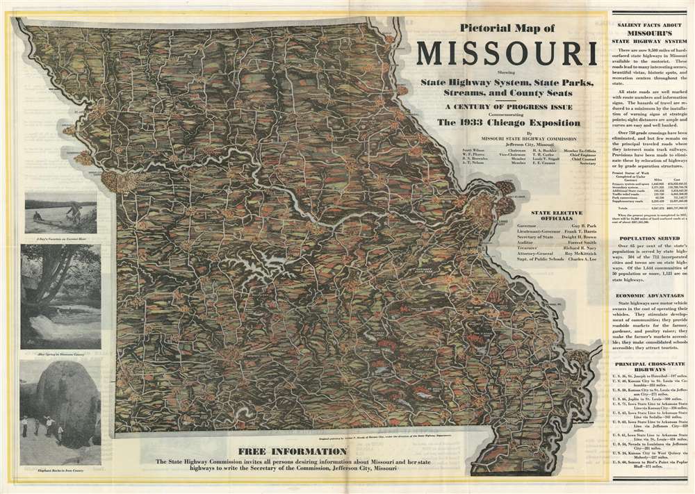
Pictorial Map of Missouri Showing State Highway System, State Parks, Streams, and County Seats. - A Century of Progress Issue Commemorating the 1933 Chicago Exposition.
1933 (dated) 19.5 x 27.75 in (49.53 x 70.485 cm) 1 : 1000000
1933 (dated) 19.5 x 27.75 in (49.53 x 70.485 cm) 1 : 1000000
Description
This is a 1933 Arthur P. Moody and Missouri State Highway Commission pictorial map of Missouri. The map depicts the entire state but leaves the neighboring states unillustrated and unidentified. The Missouri River creates the northern third of the state's western border and also remains unlabeled, while the Mississippi River serves as the state's entire eastern border and likewise is not identified. State highways snake their way across the state, all of which are labeled by highway signs either in the shape of the state of Missouri or the U.S. Highway shield. Cities and towns are illustrated and labeled, with the largest cities, such as St. Joseph, Kansas City, Jefferson City, and St. Louis highlighted by profile illustrations of some of the city's more recognizable buildings. State parks are labeled throughout the state, almost all of which are located in the southern third. Facts about Missouri are included along the right side, promoting the many benefits of the Missouri state highway system. Printed photographs documents a day on Current River, Alley Spring in Shannon County, and the Elephant Rocks in Iron County are situated along the left border.
Publication History and Census
This map was created by artist Arthur P. Moody for publication by the Missouri State Highway Commission in 1933. The OCLC records examples of this map in the institutional collections at Ball State University, the University of Chicago, the University of Illinois Urbana-Champaign, the Wisconsin Historical Society, and the University of Minnesota, Minneapolis.Condition
Very good. Even overall toning. Verso repairs to fold separations. Closed margin tears professionally repaired on verso. Text and other content on verso.
References
OCLC 37442078.