This item has been sold, but you can get on the Waitlist to be notified if another example becomes available.
1956 Moss Pictorial Map of Wildlife and Game in the United States
PictorialWildlife-moss-1956-2$225.00


Title
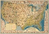
Sportsman's Map of U.S. Wildlife.
1956 (dated) 22.25 x 31.5 in (56.515 x 80.01 cm) 1 : 6970000
1956 (dated) 22.25 x 31.5 in (56.515 x 80.01 cm) 1 : 6970000
Description
An impressive 1956 Ira Moss pictorial map of wildlife and game native to the United States, sponsored by Outdoor Life magazine and the Marlin Firearms Company. It depicts the richness and variety of fauna in the continental U.S. in fantastic detail.
Large illustrations of deer, elk, black bear, bighorn sheep, bison, moose, and pronghorn antelope are the most striking, while smaller illustrations of the birds and other animals populate the areas not occupied by the larger illustrations. Boxed inset maps along each of the four borders depict the ranges of each of the species on the map. For birds, some differentiation is created through shading to indicate their wintering and nesting areas.
167 national forests are also indicated and indexed towards bottom-left, with sketches of green pine trees marking the location of each national forest. Rivers, lakes, cities, and state capitals are also labeled throughout. The whole is surrounded by a charming border made up of small sketches of birds in flight.
A Closer Look
Bright, colorful, and highly detailed, fifty-five different mammal species and sixty-eight different bird species are illustrated. Each species is numbered and corresponds with an index located in a cartouche towards lower-left. The mammals are listed in black and divided into four categories: big game, small game, animal predators, and small mammals. The birds are listed in red text and divided into five categories: upland game birds, shore birds, winged predators, geese and brant, and ducks. Each of the listed species appears on the map several times, and each illustration is numbered for easy identification.Large illustrations of deer, elk, black bear, bighorn sheep, bison, moose, and pronghorn antelope are the most striking, while smaller illustrations of the birds and other animals populate the areas not occupied by the larger illustrations. Boxed inset maps along each of the four borders depict the ranges of each of the species on the map. For birds, some differentiation is created through shading to indicate their wintering and nesting areas.
167 national forests are also indicated and indexed towards bottom-left, with sketches of green pine trees marking the location of each national forest. Rivers, lakes, cities, and state capitals are also labeled throughout. The whole is surrounded by a charming border made up of small sketches of birds in flight.
Publication History and Census
This map was designed by Ira Moss in 1956. At least three editions exist, all dated to 1956, which can be distinguished by their titles, title cartouches, and coloration, but which otherwise are essentially the same. This edition is only noted among the holdings of Northern Illinois University.Cartographer
Ira Moss (fl. c. 1954 - 1956) was an American painter and graphic designer active in New York City during the mid-20th century. His corpus includes pictorial maps of New York City as well as national 'fish and game' maps. More by this mapmaker...
Condition
Fair. Minor wear on surface causing small areas of loss around borders. Missing lower right corner, professional infill and facsimile repair.
References
OCLC 12487306. Rumsey 8425.000 (variant edition).