1882 Weldin / Rand McNally Map of Pittsburgh
PittsburghAllegheny-randmcnally-1882$500.00

Title
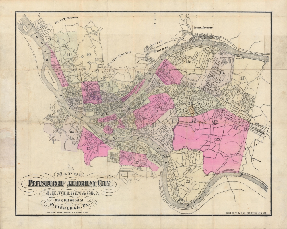
Map of Pittsburgh and Allegheny City.
1882 (dated) 21.25 x 26.5 in (53.975 x 67.31 cm) 1 : 24000
1882 (dated) 21.25 x 26.5 in (53.975 x 67.31 cm) 1 : 24000
Description
A large and colorful 1882 city plan or map of Pittsburgh and environs produced by J. R. Weldin and Rand McNally. It illustrates the city as it appeared during the 'Second Industrial Revolution', an economic boom driven by steel, chemicals, and other industries.
Several of the leading American entrepreneurs of the late 19th century made their fortunes in the city, including the Mellon family, Andrew Carnegie, Henry Clay Frick, Charles Schwab, and George Westinghouse. At the same time, the city became one of the mainstays of the American labor movement. The tension between capital and labor, combined with the economic fallout of the Panic of 1873, led to the Pittsburgh Railroad Strikes of 1877, one of the most violent incidents of labor unrest in American history.
A Closer Look
Pittsburgh and its environs, including the independent municipality of Allegheny (City), are depicted, divided into wards. The development and industrialization is readily apparent with the proliferation of railroad lines and bridges across the Allegheny and Monongahela Rivers. Along the outskirts of both cities, roads are marked out in the absence of buildings, indicating anticipated urban growth. The layout of the city is defined by its characteristic hills, reflected here even without a topographical referent by the density of certain areas versus others.The Steel City Emerges
Building from the basis of Fort Pitt at the meeting of the Allegheny, Monongahela, and Ohio Rivers, Pittsburgh developed an association with metals manufacturing early on, especially brass, tin, and iron. Its location along the three rivers, especially the Ohio, also was a boon to commerce, allowing the easy transfer of goods. The arrival of railroads and the U.S. Civil War were important in boosting the city's development and growth into surrounding countryside (Allegheny City, here as a separate municipality, was annexed by Pittsburgh in 1907).Several of the leading American entrepreneurs of the late 19th century made their fortunes in the city, including the Mellon family, Andrew Carnegie, Henry Clay Frick, Charles Schwab, and George Westinghouse. At the same time, the city became one of the mainstays of the American labor movement. The tension between capital and labor, combined with the economic fallout of the Panic of 1873, led to the Pittsburgh Railroad Strikes of 1877, one of the most violent incidents of labor unrest in American history.
Publication History and Census
This map was designed by J. R. Weldin and Co. and engraved by Rand McNally and Co. It is listed among the holdings of the University of Houston, the New York Public Library, and the National Library of Scotland, and has no known history on the market.CartographerS
Rand, McNally and Co. (fl. 1856 - present) is an American publisher of maps, atlases and globes. The company was founded in 1856 when William H. Rand, a native of Quincy, Massachusetts, opened a print shop in Chicago. Rand hired the recent Irish immigrant Andrew McNally to assist in the shop giving him a wage of 9 USD per week. The duo landed several important contracts, including the Tribune's (later renamed the Chicago Tribune) printing operation. In 1872, Rand McNally produced its first map, a railroad guide, using a new cost effective printing technique known as wax process engraving. As Chicago developed as a railway hub, the Rand firm, now incorporated as Rand McNally, began producing a wide array of railroad maps and guides. Over time, the firm expanded into atlases, globes, educational material, and general literature. By embracing the wax engraving process, Rand McNally was able to dominate the map and atlas market, pushing more traditional American lithographic publishers like Colton, Johnson, and Mitchell out of business. Eventually Rand McNally opened an annex office in New York City headed by Caleb S. Hammond, whose name is today synonymous with maps and atlases, and who later started his own map company, C. S. Hammond & Co. Both firms remain in business. More by this mapmaker...
Josiah Ross Weldin (fl. (1852 - 2020) was a bookseller and stationer based in downtown Pittsburgh, Pennsylvania. The firm operated as J. R. Weldin and Co. from 1852 to 2020. Learn More...
Condition
Good. Wear and discoloration along fold lines, with some loss at fold intersections. Light foxing and offsetting. Spot of discoloration at right-center. Pencil annotations follows routes of roads in Allegheny City.
References
OCLC 38451263.