This item has been sold, but you can get on the Waitlist to be notified if another example becomes available, or purchase a digital scan.
1887 Meiji Era Ozaki Map of Yokohama, Japan
PlamofYokohama-ozaki-1887$900.00

Title
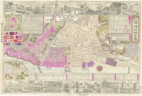
改良横濱明細全図 / Plam of Yokohama.
1887 (dated) 29 x 28 in (73.66 x 71.12 cm) 1 : 7500
1887 (dated) 29 x 28 in (73.66 x 71.12 cm) 1 : 7500
Description
A colorful and rare Meiji 20 or 1887 Map of Yokohama, Japan by Tomigorō Ozaki (尾崎富五郎). Oriented to the southwest, this map details central Yokohama, at the time most international and industrialized city in Japan, with foreign settlements extending form the Bluff to Yokohama Chinatown. The cartographer here stresses the intentionality of the settlement, with a chart of flats at left center representing the largest foreign contingents in Yokohama. The map is surrounded by copper engraved views of city life stressing the international presence, busy port, and combination of traditional and western architecture. There are lists of town names, bridge names, distance charts, railroad timetables, and more. The text throughout is partially in Kanji, partially in Katakana, and bears an English title which, charmingly, is misspelled ('Plam' vs. Plan).
This map was issued in Yokohama by Tomigorō Ozaki. It is rarely seen on the market and represented in only 4 known institutional examples.
This map was issued in Yokohama by Tomigorō Ozaki. It is rarely seen on the market and represented in only 4 known institutional examples.
Cartographer
Tomigorō Ozaki (1822 - 1893) was a Japanese editor and printer active in Yokohama during the Meiji Period. More by this mapmaker...
Condition
Very good. Two panels joined by publisher. Folds into original binder.
References
National Library of Australia, 442808857. OCLC 676684321.