This item has been sold, but you can get on the Waitlist to be notified if another example becomes available, or purchase a digital scan.
1847 Levasseur Map of the World
Planisphere-levassuer-1847$200.00

Title
Planisphere.
1847 (undated) 12 x 16.5 in (30.48 x 41.91 cm)
1847 (undated) 12 x 16.5 in (30.48 x 41.91 cm)
Description
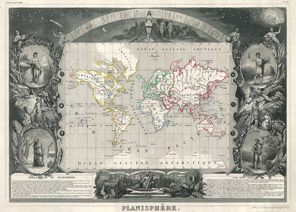
This is a rare 1847 map of the world by French map publisher Victor Levasseur. Probably Levassuer's most sought after atlas map. Depicts the world on a Mercator projection with continents and some countries defined with outline color. Offers a few elements of geographical interest. This map shows the Oregon-Canada border extending northward into what is today British Columbia along the 54°40' north parallel. Map layout, if not the map itself, predates acquisition of California and Texas by the United States. Traces of Antarctica appear along the bottom of the map where various explorers sighted land.
The entire map is surrounded by a fantastic allegorical border typical of Levasseur's Atlas Illustre. Designed by Raimond Bonheur, father of the famous French artist Rosa Bonheur, this is one of the most fantastic border designs to appear in any 19th century map. The map proper is flanked on either side by figures representing the four seasons. At the top of the map stars dot the firmament behind the arc of the Zodiac. Under the Zodiac Adam and Even appear, hand in hand, walking toward a four breasted female figure, possibly Pandora, holding a box. Below the map Jesus sits enthroned with Moses, the Pyramids of Egypt, a domed hall, and other figures to either side. Text at the base of the map describes each of the five recognized continents.
Prepared by V. Levassuer from his office at 43 Rue St. Jacques, Paris, for issue as plate no. 93 in the 1847 edition of the Atlas Illustre…
Cartographer
Victor Levasseur (1800 - 1870), an important French engineer, cartographer, and engraver of the mid 19th century, held a number of important cartographically related political and educations posts in France. He is most famous for his Atlas National Illustré des 86 Départements et des Possessions de La France, a large decorative atlas of France, including his Planisphere and five important continental maps. Levasseur's maps are distinctive for their wide decorative margins containing elaborate depictions of the scenery, peoples, and trade goods of the areas he mapped. Levasseur maps are also known to offer a wealth of statistical data. Until recently, very few Levasseur Atlases migrated out of France where they were mostly used in public libraries and town halls. His work represents some of the last great decorative atlases of the 19th century. More by this mapmaker...
Source
Levassuer, V., Atlas National Illustre des 86 Departements et des Possessions de La France, 1847 edition.
Condition
Very good condition. Not notable flaws. Blank on verso.
References
National Library of Australia, 1847 MAP NK 6095.