This item has been sold, but you can get on the Waitlist to be notified if another example becomes available, or purchase a digital scan.
1878 Migeon Map of the Stars and Constellations
PlanisphereCeleste-migeon-1878$85.00

Title
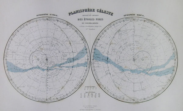
Planisphere Celeste Donnant Les Divisions Des Etoiles Fixes en Constellations et leurs classifications jusqua'a la 5eme Grandeur.
1878 11 x 16 in (27.94 x 40.64 cm)
1878 11 x 16 in (27.94 x 40.64 cm)
Description
This hand colored celestial map of the Stars and Constellations is a steel plate engraving, dating to 1878 by the well regarded French cartographer Migeon. This map depicts the night skies of both the northern and southern hemispheres. Migeon's Geographie Universelle, published in Paris, is one of the last fine atlases produced in the 19th century. It contains many stylistic elements of early 19th century cartography such as full hand coloring, numerous decorative vignettes, and high quality low acid paper.
Cartographer
J. Migeon (fl. c. 1855 - 1899) was a late 19th century map publisher based in Paris, France. At various times Migeon maintained offices at76, Rue de la Harpe, 34 Rue du Chemin des Plantes, and 11 Rue du Moulin Vert, all in Paris. His most prominent publications are the Geographie Universal in 1854 (updated through 1874) and the Nouvel Atlas Illustré de Géographie Universelle in 1891. Little is known of Migeon's life and even his first name is uncertain. More by this mapmaker...
Condition
Vert good condition.