This item has been sold, but you can get on the Waitlist to be notified if another example becomes available, or purchase a digital scan.
1935 Editorial Ràpido Map or Plan of Barcelona, Spain
PlanoBarcelona-rapido-1935$150.00

Title
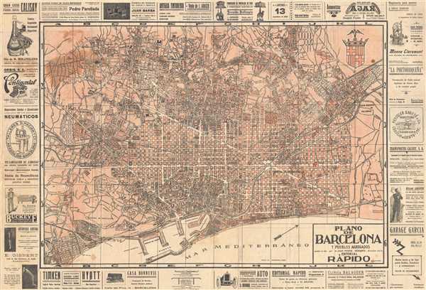
Plano de Barcelona y Pueblos Agregados.
1935 (undated) 26 x 38.5 in (66.04 x 97.79 cm) 1 : 14000
1935 (undated) 26 x 38.5 in (66.04 x 97.79 cm) 1 : 14000
Description
This is a 1935 Editorial Ràpido city map or plan of Barcelona, Spain. The map depicts the city of Barcelona from the Hosta Francas neighborhood on the left to San Andres de Palomar on the right and from Sarriá and Horta on the top to the port and the Mediterranean Sea on the bottom. The map is very detailed, labeling both major and minor streets and depicts the city in blocks. Different neighborhoods and suburbs are labeled. The port is depicted in details well as the rail lines. The coat of arms of the city of Barcelona is depicted in the upper right corner. Interestingly, the map is bordered by advertisements. These ads, however, do not appear to be for typical tourist fare alone, such as restaurants, hotels, and the like. These advertisements are also for typewriters, furniture manufacturers, and artificial limbs.
This map was published by Editorial Ràpido in 1935, most likely for city guidebooks.
This map was published by Editorial Ràpido in 1935, most likely for city guidebooks.
Condition
Very good. Backed on archival tissue for stability. Soiling at top left corner of printed area.
References
OCLC 733723969.