This item has been sold, but you can get on the Waitlist to be notified if another example becomes available, or purchase a digital scan.
1799 Cary Map of Poland, Prussia and Lithuania
Poland-cary-1799$150.00

Title
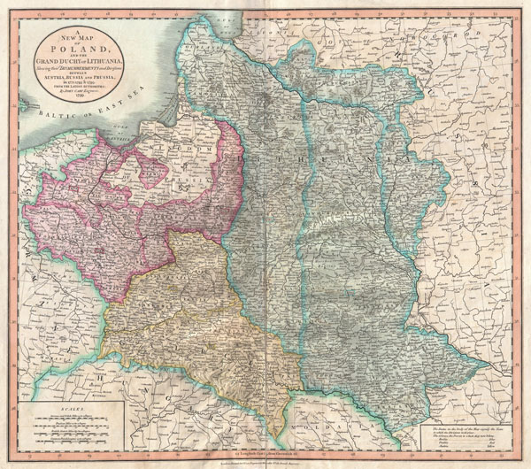
A New Map of Poland and the Grand Duchy of Lithuania, Shewing their Dismemberments and Divisions between Austria, Russia and Prussia in 1772, 1793, & 1795.
1799 (dated) 18.25 x 20.5 in (46.355 x 52.07 cm)
1799 (dated) 18.25 x 20.5 in (46.355 x 52.07 cm)
Description
A nice example of John Cary's rare 1799 map of Poland. Covers the entire block of territory claimed by the Polish-Lithuanian Commonwealth (Rzeczpospolita) from the Baltic Sea south to Hungary and eastward as far as Russia. This map is designed to illustrate the partitioning of Poland between Austria, Russia and Prussia at the end of the 18th century – just a few years before this map was published. Russia claimed the bulk of what once comprised the Grand Duchy of Lithuania from Livonia south to Moldava. Prussia claimed the territory east of Warsaw and south to Galicia. The Austrian Empire annexed Galicia. Poland remained thus divided until the end of World War I. In 1919 United States President Woodrow Wilson called for the reconstitution of Poland in his historic Fourteen Points. This map was prepared in 1799 by John Cary for issue in his magnificent 1808 New Universal Atlas.
Cartographer
John Cary (1754 - 1835) was a London based cartographer active in the early part of the 19th century. Ronald Vere Tooley, the prominent English map historian, writes of Cary, "As an engraver he was elegant and exact with fine clear lettering and great delicacy of touch." Cary began his work as an engraver, cartographer, and globe maker in 1776 with his New and Correct English Atlas. This important atlas represented a new phase in cartography where accuracy and detail rose in prominence over the decorative embellishments of the 18th century. This change was indicative of the times when travel and commerce were expanding globally as never before. Cary's mastery of both engraving and cartography resulted in a series of seminal works that redefined mapmaking in the early 19th century. His stupendous Cary's New Universal Atlas, published in 1808, set the standard for all cartographers who followed. Cary reissued this seminal atlas in 1811, 1819, 1824, 1828, 1833, 1836 and 1844. Cary also did considerable work on the English Ordinance Survey prior to 1805. His cartographic work particularly inspired the Edinburgh school of cartography as represented by John Pinkerton and John Thomson. In America, Cary's work was used as the basis for Tanner's important New American Atlas. Cary's last published atlas appeared posthumously in 1844, however, by 1850 Cary's work was being carried on by his sons and other well-known cartographers including James Wyld, John Tallis & Company, and Crutchley. More by this mapmaker...
Source
Cary, John, Cary's New Universal Atlas, containing distinct maps of all the principal states and kingdoms throughout the World. From the latest and best authorities extant. London: Printed for J. Cary, Engraver and Map-seller, No. 181, near Norfolk Street, Strand, 1808.
Condition
Good condition. Old closed repair and reinforcement on original centerfold Repaired closed tear from centerfold, at center, running about six inches into Prussia - see zoom in photo as this is barely visible. Minor buckling to the left and right of centerfold.
References
Rumsey 1657.036. Malinowski, H., The Malinowski Cllection of Maps of Poland, 47. Phillips (Atlases) 714. The Map Collector, issue 43, p. 40-47 (Atlas). National Maritime Museum, v. 3, no. 311 (Atlas).