This item has been sold, but you can get on the Waitlist to be notified if another example becomes available, or purchase a digital scan.
1811 Cary Map of Poland, Prussia and Lithuania
Poland-cary-1811$150.00

Title
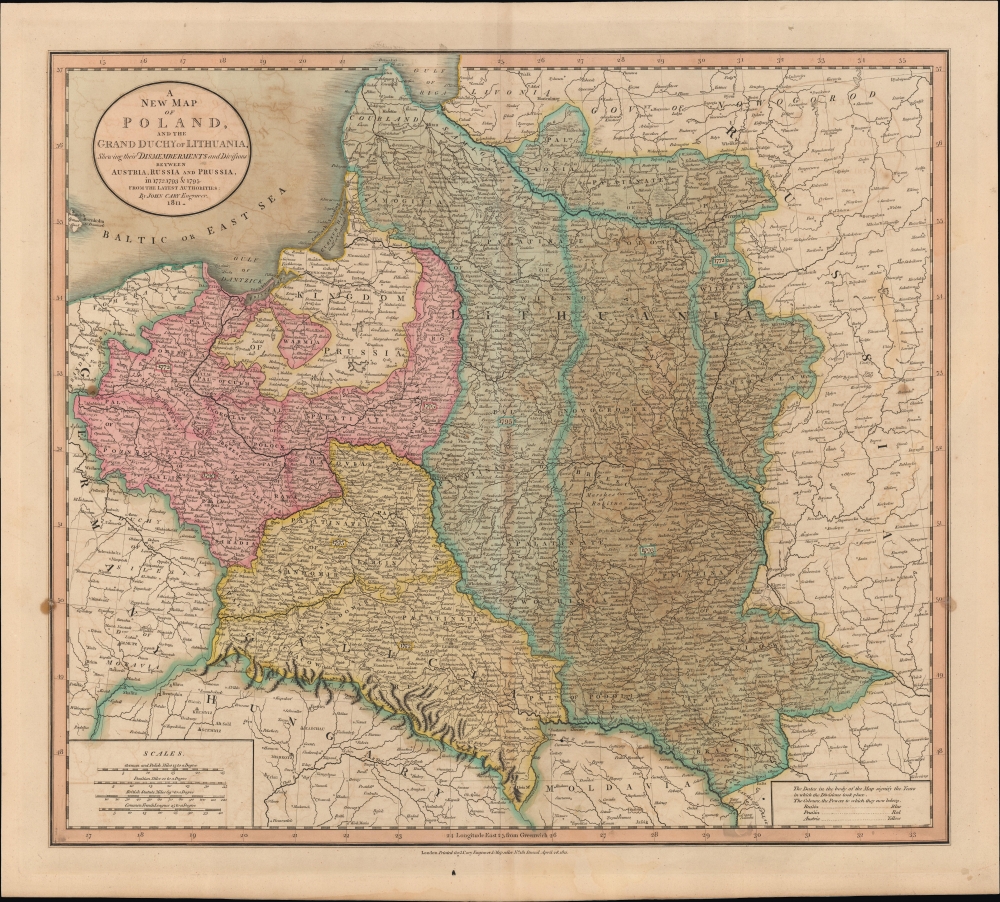
A New Map of Poland and the Grand Duchy of Lithuania, Shewing their Dismemberments and Divisions between Austria, Russia and Prussia in 1772, 1793, and 1795.
1811 (dated) 18.25 x 20.5 in (46.355 x 52.07 cm) 1 : 2600000
1811 (dated) 18.25 x 20.5 in (46.355 x 52.07 cm) 1 : 2600000
Description
An example of John Cary's 1811 map of Poland, as partitioned in the late 18th century. At the time of publication, Poland regained a degree of nominal independence via the Napoleonic Duchy of Warsaw.
Likely due to the volatility of the Napoleonic Wars (1803 - 1815), and a desire not to legitimize the actions of Britain's enemy, Cary has retained the borders of Poland at the start of the conflict. Poland (and Lithuania) would be reborn and reconquered over the following two centuries, and, with additional border changes in the 20th century, Poland 'shifted' considerably to the west. Warsaw, at left-center here, is now in the eastern part of the country, while Brest (Brześć Litew), slightly left of center here, is no longer part of Poland at all but was at the western edge of Belarus.
A Closer Look
Coverage includes the block of territory claimed by the Polish-Lithuanian Commonwealth (Rzeczpospolita) from the Baltic Sea south to Hungary and eastward as far as Russia. Cities, towns, roads, rivers, mountains, administrative borders, and other features are labeled. This map is designed to illustrate the partitioning of Poland between Austria, Russia, and Prussia at the end of the 18th century. The portions of the commonwealth going to the three major powers are color shaded, with the dates of partition indicated in boxes. Russia claimed the bulk of what once comprised the Grand Duchy of Lithuania from Livonia south to Moldavia. Prussia claimed the territory east of Warsaw and south to Galicia. The Austrian Empire annexed Galicia. Poland remained thus divided until the end of World War I (1914 - 1918).Poland - Stuck between Great Powers
The Polish-Lithuanian Commonwealth suffered at the hands of Russia, Prussia, and Austria in the 18th century, when the three states conspired to reduce and then eliminate the commonwealth, a feat accomplished between 1772 and 1795. But Polish nationalism had been enflamed by the American and French Revolutions, and the Napoleonic Wars offered an opportunity to recreate a Polish state. Following a popular uprising in 1806, Napoleon carved off a portion of Prussia to create the Duchy of Warsaw, a move which endeared him to Poles (tens of thousands of whom joined his armies at various points in the conflict) but greatly annoyed Russia, helping lead to their enmity several years later. However, the duchy was a French client state with limited autonomy, and short lived in any case, having been occupied by Russia in 1813 following Napoleon's disastrous invasion of Russia the previous year.Likely due to the volatility of the Napoleonic Wars (1803 - 1815), and a desire not to legitimize the actions of Britain's enemy, Cary has retained the borders of Poland at the start of the conflict. Poland (and Lithuania) would be reborn and reconquered over the following two centuries, and, with additional border changes in the 20th century, Poland 'shifted' considerably to the west. Warsaw, at left-center here, is now in the eastern part of the country, while Brest (Brześć Litew), slightly left of center here, is no longer part of Poland at all but was at the western edge of Belarus.
Publication History and Census
This map was prepared in 1811 by John Cary for issue in his magnificent New Universal Atlas.Cartographer
John Cary (1754 - 1835) was a London based cartographer active in the early part of the 19th century. Ronald Vere Tooley, the prominent English map historian, writes of Cary, "As an engraver he was elegant and exact with fine clear lettering and great delicacy of touch." Cary began his work as an engraver, cartographer, and globe maker in 1776 with his New and Correct English Atlas. This important atlas represented a new phase in cartography where accuracy and detail rose in prominence over the decorative embellishments of the 18th century. This change was indicative of the times when travel and commerce were expanding globally as never before. Cary's mastery of both engraving and cartography resulted in a series of seminal works that redefined mapmaking in the early 19th century. His stupendous Cary's New Universal Atlas, published in 1808, set the standard for all cartographers who followed. Cary reissued this seminal atlas in 1811, 1819, 1824, 1828, 1833, 1836 and 1844. Cary also did considerable work on the English Ordinance Survey prior to 1805. His cartographic work particularly inspired the Edinburgh school of cartography as represented by John Pinkerton and John Thomson. In America, Cary's work was used as the basis for Tanner's important New American Atlas. Cary's last published atlas appeared posthumously in 1844, however, by 1850 Cary's work was being carried on by his sons and other well-known cartographers including James Wyld, John Tallis & Company, and Crutchley. More by this mapmaker...
Source
Cary, J., Cary's New Universal Atlas, (London) 1811.
Condition
Good. Slight toning along centerfold. Light offsetting. Soiling on left and right border.
References
Rumsey 1657.036. OCLC 958163477. Malinowski, H., The Malinowski Collection of Maps of Poland, 47. Phillips (Atlases) 714. The Map Collector, issue 43, p. 40-47 (Atlas). National Maritime Museum, v. 3, no. 311 (Atlas).