This item has been sold, but you can get on the Waitlist to be notified if another example becomes available, or purchase a digital scan.
1710 Chatelain Map of the Kingdom of Poland (Polish-Lithuanian Commonwealth)
Poland-chatelain-1710$425.00

Title
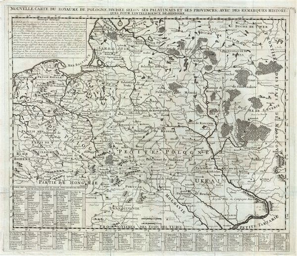
Nouvelle Carte du Royaume de Pologne Divisee Selon ses Palatinats et ses Provinces, avec des Remarques Historiques pour L'Intelligence de l'Histoire.
1710 (undated) 21 x 24 in (53.34 x 60.96 cm)
1710 (undated) 21 x 24 in (53.34 x 60.96 cm)
Description
An extraordinary map of Poland issued c. 1710 by Henri Chatelain. Centered on 'Petite Pologne,' the map covers from the Baltic Sea to Transylvania and from Glatz to the border with Moscovie (Russia). Like most of Chatelain's work it is beautifully engraved and masterfully printed on fine paper using an intense dark ink. This striking effect beautifully illustrates the region with forests and mountains appearing in profile. Important cities and Platinates are identified throughout as are lesser cities, castles, and waterways.
As this map was being printed the Polish-Lithuanian Commonwealth was suffering from political and social upheaval. Following the death of King John III Sobieski and the end of Poland's Golden Age, a series of internal conflicts and external invasions destabilized the region to the brink of anarchy. The rapacious Russian empire, under Tzar Peter the Great, used its influence to further weaken the state in anticipation of outright annexation. By 1768 the Polish-Lithuanian Commonwealth had become a protectorate of Imperial Russia.
Without a doubt one of the most beautiful 18th century atlas maps of Poland, this chart was issued as plate no. 19 in volume 4 of Chatelain's Atlas Historique.
Cartographer
Henri Abraham Chatelain (1684 - 1743) was a Huguenot pastor of Parisian origins. He lived consecutively in Paris, St. Martins, London (c. 1710), The Hague (c. 1721) and Amsterdam (c. 1728). He is best known as a Dutch cartographer and more specifically for his cartographic contribution in the seminal seven volume Atlas Historique, published in Amsterdam between 1705 and 1720. Innovative for its time, the Atlas Historique combined fine engraving and artwork with scholarly studies of geography, history, ethnology, heraldry, and cosmography. Some scholarship suggests that the Atlas Historique was not exclusively compiled by Henri Chatelain, as is commonly believed, but rather was a family enterprise involving Henri, his father Zacharie and his brother, also Zacharie. More by this mapmaker...
Source
Chatelain, H. A., Atlas Historique (Amsterdam) 1705-1720.
Condition
Very good. Original fold lines visible. Blank on verso. Original platemark visible. A couple minor verso repairs and reinforcements.