This item has been sold, but you can get on the Waitlist to be notified if another example becomes available, or purchase a digital scan.
1708 Senex Map of Poland: a Likely First State
Poland-senex-1708$425.00

Title
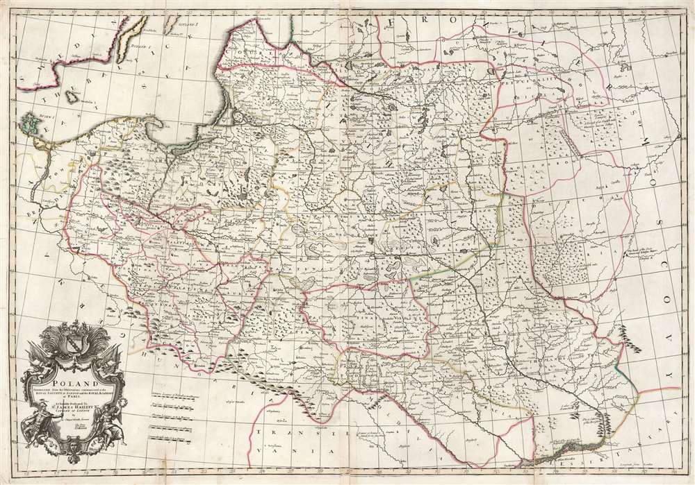
Poland: corrected from the observations communicated to the Royal Society at London and the Royal Academy at Paris.
1708 (undated) 26 x 37.75 in (66.04 x 95.885 cm) 1 : 740000
1708 (undated) 26 x 37.75 in (66.04 x 95.885 cm) 1 : 740000
Description
This is a lovely, original old color example of John Senex' important map of Poland, one of the largest English maps of the Polish-Lithuanian Commonwealth. The map reaches from the Baltic, Silesia and Hungary in the west to Biela, Molenskow and Severia in the east. It is superbly engraved and richly detailed, with mountains and forests rendered pictorially. The cartouche, with its dedication to Sir James Hallett, has a particularly martial character. Surmounted with weapons, it is flanked by figures representing Mars and Winged Victory, perhaps alluding to the many wars suffered by the Commonwealth. It is unclear what connection Sir James Hallett (1690 - 1734, who may have been a Goldsmith, might have had with the subject matter.
OCLC lists only one example of this map with Price's name on the imprint, that being at the British Library. They date it 1710; but, we believe this to be an error, and consider it probably a 1708 printing and thus a putative first state. A more completely catalogued example at the National Library of Wales lacking the Price imprint is given a 1710 date. Only three examples, dated 1710 and 1711, are catalogued including Maxwell's imprint: these representations we tentatively categorize as second states. The third state, printed beginning in 1721 and appearing in numerous atlases, is well represented in institutional collections.
Publication History and Census
The mapmakers are listed under the joint imprint of Charles Price, John Senex, and John Maxwell. This trio of map sellers, late of John Sellers' shop, were selling maps together as early as 1708. We see all three on various of Senex's maps given this date. The partnership did not last, and by 1710, Price's name was removed from the plate. Sometime after 1712, Maxwell's name was likewise burnished out.OCLC lists only one example of this map with Price's name on the imprint, that being at the British Library. They date it 1710; but, we believe this to be an error, and consider it probably a 1708 printing and thus a putative first state. A more completely catalogued example at the National Library of Wales lacking the Price imprint is given a 1710 date. Only three examples, dated 1710 and 1711, are catalogued including Maxwell's imprint: these representations we tentatively categorize as second states. The third state, printed beginning in 1721 and appearing in numerous atlases, is well represented in institutional collections.
CartographerS
John Senex (1678 - 1740) was an English engraver and map maker active in London during the first half of the 18th century. Senex was born to upper middle class parents in Shropshire, England. As a young man, he was apprenticed to Robert Clavell, a London bookseller and member of the Stationers' Company, under whom he mastered the arts of engraving and printmaking. Around 1702 Senex completed his apprenticeship and established himself as a printer and bookseller in the Strand. A year later Senex partnered with Jeremiah Seller and Charles Price, the successors to the important mapmaker John Seller, and relocated to Cornhill. This was likely Senex's first introduction to mapmaking though he seems to have taken to it with abandon. In the subsequent years Senex established himself as one of the most prominent cartographers in London, publishing a number of beautiful and important maps that today rank among the finest examples from the Golden Age of British Cartography. In addition to a large corpus of flat maps, Senex also produced a number of important and highly desirable globes. Eventually Senex dissolved his partnership with Seller and Price and relocated to Fleet Street, where he maintained offices until his death in 1740. Senex was succeeded by his widow, Mary Senex, who continued to publish and update his works until about 1755, when the remaining globe and map plates were sold to James Ferguson. More by this mapmaker...
Charles Price (1679? - 1733) was an English instrument-maker, engraver, surveyor, mapmaker and mapseller. In the course of his career collaborated with many of the leading lights of English cartography. Nothing is known of his childhood. He was apprenticed to the mapmaker John Seller in 1694, and witnessed his master's will; he and Jeremiah Seller became free in 1703 and entered into a partnership. He moved on to work with John Senex from 1705-1710, and George Willdey from 1710 to 1713. He also worked with instrument maker Benjamin Scott. He appears to have been prolific. Unfortunately, by 1731 he was in debtors' prison; he died in 1733. Learn More...
John Maxwell (fl 1707-1714) was an English mapseller, globe seller and author. He worked with John Senex from 1709 as late as 1718, although his work with Senex may have practically ended in 1714. Learn More...
Source
Senex, J. Modern Geography, or all Known Countries of the World ... (London), 1708-1725.
Condition
Good. Several mended splits at folds, and one mended tear at top with no loss. Original outline color, with a bold sharp strike.
References
OCLC 1118013586. Rumsey 13539.028 (1732 Willdey edition). Malinowski, H. in Map Collectors' Circle no. 43 #440, M355 (misdated).