This item has been sold, but you can get on the Waitlist to be notified if another example becomes available, or purchase a digital scan.
1854 Spruner Map of Poland to 1795
Poland-spruner-1854$75.00

Title
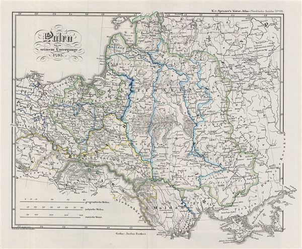
Polen bis zu seinem Untergange 1795.
1855 (dated) 14 x 17 in (35.56 x 43.18 cm)
1855 (dated) 14 x 17 in (35.56 x 43.18 cm)
Description
This is Karl von Spruner's 1854 historical map of Poland from the first Partition of Poland in 1772, through the Second and Third Partitions, to the dissolution of the Polish-Lithuanian Commonwealth in 1795. The map coves Poland from Livonia to Moldavia and shows parts of neighboring Russia and Germany. The map details the critical year of 1795, when the Third (and last) Partition of Poland permanently dissolved the Polish-Lithuanian Commonwealth. Following the First and the Second Partitions of Poland, which were influenced by rise of the Russian empire, increasing unrest in the remaining commonwealth provinces led Polish nationalist demands for reunification. The only way to resolve this issue, as seen by the partitioning powers, was to eliminate entirely the independent Polish state. In 1775, in the Third Partition, the remaining territories of the Polish-Lithuanian Commonwealth were divided between Russia, Prussia and Austria. The whole is rendered in finely engraved detail exhibiting throughout the fine craftsmanship of the Perthes firm. Prepared by Karl Spruner for publication as plate N VI in the second edition of Justus Perthes' 1854 Historich-Geographischer, Hand-Atlas zur Geschichte der Staaten europa's vom Anfang des Mittelalters bis auf die Neueste Zeit.
CartographerS
Karl von Spruner (November 15, 1803 - August 24, 1892) or Spruner Karl von Merz or Spruneri was a Stuttgart born cartographer, scientist, and map publisher active in Germany during the middle part of the 19th century. Joining the Bavarian army at the tender age of 11, Spruner dedicated most of his life to military service. Spruner's superiors, recognizing his keen intellect, eventually assigned him to the army's cartographic division. Military education earned him the title of Doctor of Cartography in 1852. In 1855 he attained the rank of Lieutenant-Colonel and, in 1883, General. Cartographically, Spruner is best known for his historical atlases, most of which were published by the Justus Perthes firm. His much admired maps studiously applied historical political geographies to contemporary physical geographies. Spruner also worked with Heinrich Theodore Menke, a well-known German mapmaker, to produce and later revise his many historical maps. In 1886, after 72 years of professional military service, Spruner formally retired. He died seven years later in Munich in on August 24th of 1892. More by this mapmaker...
Johan Georg Justus Perthes (September 11, 1749 - May 2, 1816) was one of the most important German cartographic engravers of the 19th century. He was born in the Thuringian town of Rudolstadt, the son of a court physician. In 1778, he began working as a bookseller in Gotha. Perthes began his publishing empire shortly thereafter with the 1784 issue of the famed survey of European nobility known as the Almanac de Gotha. In the next year, 1785, he founded the cartographic firm of Justus Perthes Geographische Anstalt Gotha. His son Wilhelm Perthes (1793 - 1853) joined the firm in 1814. Wilhelm had prior publishing experience at the firm of Justus Perthes' nephew, Friedrich Christoph Perthes, who ran a publishing house in Hamburg. After Justus Perthes died in 1816, Wilhelm took charge and laid the groundwork for the firm to become a cartographic publishing titan. From 1817 to 1890. the Perthes firm issued thousands of maps and more than 20 different atlases. Along with the visionary editors Hermann Berghaus (1797 - 1884), Adolph Stieler (1775 - 1836), and Karl Spruner (1803 - 1892), the Perthes firm pioneered the Hand Atlas. When Wilhelm retired, management of the firm passed to his son, Bernhardt Wilhelm Perthes (1821 – 1857). Bernhardt brought on the cartographic geniuses August Heinrich Peterman (1822 - 1878) and Bruno Hassenstein (1839 - 1902). The firm was subsequently passed to a fourth generation in the form of Berhanrd Perthes (1858 – 1919), Bernhard Wilhelm's son. The firm continued in the family until 1953 when, being in East Germany, it was nationalized and run as a state-owned enterprise as VEB Hermann Haack Geographisch-Kartographische Anstalt Gotha. The Justus family, led by Joachim Justus Perthes and his son Wolf-Jürgen Perthes, relocated to Darmstadt where they founded the Justus Perthes Geographische Verlagsanstalt Darmstadt. Learn More...
Source
Spruner, Karl, Historich-Geographischer, Hand-Atlas zur Geschichte der Staaten Europa's vom Anfang des Mittelalters bis auf die Neueste Zeit, 1854.
Condition
Very good. Blank on verso. Original centerfold. Original platemark visible.
References
Rumsey 2600.045. OCLC 4125021.