This item has been sold, but you can get on the Waitlist to be notified if another example becomes available, or purchase a digital scan.
1831 Lizars Map of Poland and Lithuania
PolandLithuania-lizars-1831$150.00

Title
Poland and Lithuania.
1831 (undated) 16.5 x 20.5 in (41.91 x 52.07 cm)
1831 (undated) 16.5 x 20.5 in (41.91 x 52.07 cm)
Description
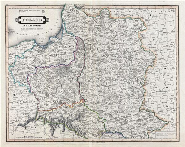
An exceptional example of Daniel Lizars' 1831 map of Poland and Lithuania. Lizars' map covers Poland following Napoleonic Wars and the treaties of the 1815 Congress of Vienna. Twenty earlier, in 1795 The Polish-Lithuanian Commonwealth was dismembered and divided between Russia, Prussia, and Austria. During Napoleon's brief period of hegemony in the region he resurrected Poland and Polish hopes for solidarity in the form of the Duchy of Warsaw. Following Napoleon's defeat at the Battle of Waterloo, the Victoria powers repartitioned Poland roughly along the lines of the 1795 Third Partition. This event is often referred to as the 'Fourth Partition of Poland' and reflects the borders presented here. Color coding identifies the powers that controlled each part of Poland with green representing Russia, Austrian claims in yellow, and Prussian dominions in blue. A third zone, highlighted in red, is identified as the 'Kingdom of Poland.' This region, surrounding Warsaw, is often called Congress Poland or the Tsardom of Poland, and was, though nominally independent, in effect a dependency of Imperial Russia. The cartographer attempts to identify the regions ceded in the various partitions with circular date cartouches here and there on the map, but lack of proper edification make these difficult to interpret. Relief is shown by hachure with towns, cities, and major topographical features identified. This map is a steel plate engraving by D. Lizars and prepared for inclusion in the 1831 edition of the edinburgh Geographical and Historical Atlas.
Cartographer
William Home Lizars (May 4, 1788 - March 30, 1859) was a mapmaker, engraver, draughtsman, lithographer, copperplate printer, painter, and publisher active in Edinburgh, Scotland. Born in Edinburgh to Daniel Lizars (1754 - 1812) and his wife Margaret Home, William apprenticed to his father (an engraver and publisher) in 1802. Beginning in 1804, he began studying at the Trustees' Academy and began a career as a painter. After his father died in 1812, William took over the family business, abandoning his promising career as a painter. William worked in partnership with his brother Daniel Lizars (May 24, 1793 - March 14, 1875) from 1812 until the partnership was formally dissolved on October 21, 1819. William published a jigsaw puzzle in 1822 that may have been the first jigsaw puzzle produced in Scotland. After William's death, William and Alexander Keith Johnston acquired the firm, launching another great cartographic firm. William married Henrietta Wilson in 1820. After leaving the partnership, William's brother Daniel became a bookseller. In 1832, he went bankrupt and in 1833 emigrated to Canada. He died in Ontario in 1875. More by this mapmaker...
Source
Lizars, D., Edinburgh Geographical and Historical Atlas, (Edinburgh) 1831.
Condition
Very good. Original centerfold. Blank on verso. Original platemark visible.
References
Rumsey 0436.020.