This item has been sold, but you can get on the Waitlist to be notified if another example becomes available, or purchase a digital scan.
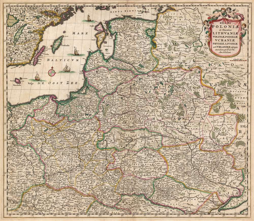
1680 De Wit Map of Poland and Lithuania
PolandLithuania-wit-1680$375.00

Title
Regni Poloniae et Ducatus Lithuaniae Voliniae, Podoliae, Ucraniae, Prussiae, Livoniae, et Curlandiae descriptio emendata per F. de Wit Amstelodami.
1680 (undated) 19 x 22 in (48.26 x 55.88 cm) 1 : 2900000
1680 (undated) 19 x 22 in (48.26 x 55.88 cm) 1 : 2900000
Description
This is a striking example of Frederik de Wit's 1680 map of the Kingdom of Poland and the Grand Duchy of Lithuania. The map spans from the Baltic Sea to the Black Sea, and from Latvia to Moldova, including much of modern-day Poland and Lithuania.
The End of a Golden Age
It represents the 'Deluge', final days of Polish Golden Age. When this map was initially engraved in 1655, the Commonwealth was one of the largest and most powerful kingdoms in Europe, stretching from modern Estonia in the north to Moldavia in the east and Bohemia in the west. The Khmelnytsky Uprising of 1648 and the Truce of Andrusovo in 1667 began a series of invasions by Russia and Sweden, collective known as 'The Deluge' or the 'Russo-Swedish Deluge'. The seemingly unending invasions laid Poland low, with the Commonwealth losing most of its power and about 1/3rd of its population. One of the most notable effects of the devastating Deluge was the subsequent weakening of Poland's international standing. With the entire Polish nation crippled by the Swedes and Russians, Russia was able to rise, found the Russian Empire in early 18th century. and play a major role in the Partitions of Poland in the latter half of the 18th century.Publication History and Census
This map was engraved by Frederick de Wit as early as 1655 and appeared in De Wit's atlas in this form until perhaps 1688. After 1689 the map's title was changed to indicate De Wit's receipt of a privilege. The present example, lacking any privilege, was certainly printed prior to 1688. The sharpness of the image suggests an early strike. In various editions this map is well represented in institutional collections.Cartographer
Frederik de Wit (1629 - 1706) was a Dutch Golden Age cartographer active in the second half of the 17th and the early 18th centuries. De Wit was born of middle class Protestant stock in the western Netherlandish town of Gouda. He relocated to Amsterdam sometime before 1648, where he worked under Willem Blaeu. His first attributed engraved map, a plan of Haarlem for Antonius Sanderus' Flandria Illustrata, was issued around this time. He struck out on his own in 1654. The first chart that De Wit personally both drew and engraved was most likely his 1659 map of Denmark, REGNI DANIÆ Accuratissima delineatio Perfeckte Kaerte van ‘t CONJNCKRYCK DENEMARCKEN. His great wall map of the world and most famous work, Nova Totius Terrarum Orbis Tabula appeared one year later. Following the publication of his wall map De Wit quickly rose in prominence as a both cartographer and engraver. He married Maria van der Way in 1661 and through her became a citizen of Amsterdam in 1662. Around this time he also published his first major atlas, a composite production ranging in size from 17 to over 150 maps and charts. Other atlases and individual maps followed. In 1689 De Wit was granted a 15 year Privilege by the Dutch States General. (An early copyright that protected the recipient's rights to print and publish.) He was recognized with the honorific 'Good Citizen' in 1694. De Wit died in 1706 after which his wife Maria continued publishing his maps until about 1710. De Wit's son, Franciscus, had no interest in the map trade, instead choosing to prosper as a stockfish merchant. On her own retirement, Maria sold most De Wit maps and plates at a public auction. Most were acquired by Pieter Mortier and laid the groundwork for the 1721 rise of Covens and Mortier, the largest Dutch cartographic publishing house of the 18th century. More by this mapmaker...
Source
De Wit, F., Atlas Tot Amsterdam, Bij Frederick de Wit in de Calverstraet bij den Dam inde Witte Paskaert, (Amsterdam: De Wit) 1680.
Condition
Very good. Even overall toning. Few mended wormholes with very slight loss. Original color.
References
Rumsey 12220.069. Malinowski, H., 'The Malinowski Collection of Maps of Poland Part I' in Map Collectors' Circle 31. No. 119. Koeman Wit 8. Carhart A100b. OCLC 316501980. Phillips (Atlases) #5389-106.