1971 Filochowska Polish Historical Map of Europe, World War II
PolesWWII-filochowska-1971$1,800.00

Title
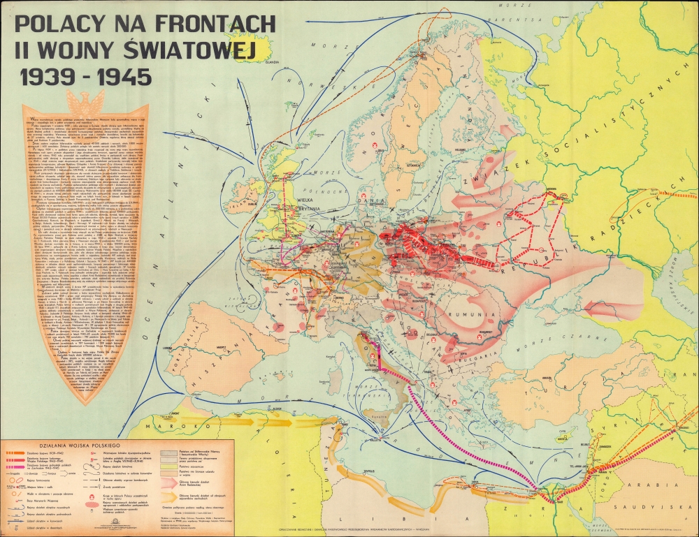
Polacy na frontach II Wojny światowej 1939-1945.
1971 (dated) 19.75 x 25.75 in (50.165 x 65.405 cm) 1 : 10000000
1971 (dated) 19.75 x 25.75 in (50.165 x 65.405 cm) 1 : 10000000
Description
This is a 1971 Państwowe Przedsiębiorstwo Wydawnictw Kartograficznych map of Europe displaying the battles of the Polish nation against Nazi Germany during the Second World War. On a per capita basis, Poland suffered more than any other country during the war, losing some 17 percent of its 1939 population in the conflict (including millions of Jews killed in the Holocaust).
Aside from those who escaped Poland in 1939, the Western Polish forces consisted mainly of Poles who had been forcibly conscripted into the Wehrmacht who then surrendered to Allied forces, as well as Poles in the Soviet Union (many of them prisoners of war from the Soviet invasion of Poland in 1939) who, after the German invasion of the latter in 1941, were transferred to fight the Germans on other fronts. One of these units, 'Anders' Army' (named for its commander Władysław Anders and discussed in some length on the shield), had a particularly circuitous route back into the fighting, based on a complex agreement between the Soviet Union, the Polish government-in-exile, and the Western Allies. Soon after the Nazi invasion of the Soviet Union, Polish prisoners of war from the Soviet invasion of Poland in 1939 were amnestied, constituted into an army, transferred across the Soviet Union to Iran (which had just been invaded and occupied in a joint British-Soviet operation), then through British Iraq and Palestine, and eventually to Italy, where they played a decisive role in the Battle of Monte Cassino, one of the most intense battles of the entire war on the Western Front.
But events not mentioned are more telling than those that are. Most obviously, no mention is made of the surprise Soviet invasion of Poland in September 1939, less than three weeks after Germany's attack, the result of a secret protocol of the Molotov-Ribbentrop Pact. Naturally, the persecution and massacres of Polish politicians and intellectuals that followed the Soviet invasion are likewise omitted. The 1944 Warsaw Uprising is discussed in some detail, but it is noted that it was initiated by 'reactionary politicians,' a reference to the primary anti-Soviet motivation behind the uprising. No mention is made of the decision by Stalin not to assist the partisans (and thereby weaken potential opponents of postwar Soviet occupation), halting his troops on the east bank of the Vistula River for months as the battle for the city raged. Incidentally, in the later stages of the uprising, the Soviet-aligned First Polish Army led by Gen. Zygmunt Berling (1896 - 1980) attempted, in an operation that their superiors may not have initially been aware of, to establish a bridgehead across the Vistula to rescue partisans, but the assault was driven back with heavy casualties. Finally, the legend briefly notes that political borders used on the map are those of the present day (1971), not those of 1939, perhaps because the borders of Poland were shifted notably to the west at the end of the war, annexing land from Germany to compensate for land in the east annexed by the Soviet Union as a 'buffer.'
A Closer Look
The map covers Europe, the Mediterranean, and parts of North Africa and the Near East. The actions of Polish forces throughout the war are marked according to the legend at the bottom left. The arrows displaying the movements of Polish forces are color-shaded, with the orange arrows representing Poles who continued fighting against Nazi Germany in the months after the latter occupied their homeland, mostly in France. The pink arrows represent the Polish Armed Forces in the West, aligned with the 'bourgeois' Polish government-in-exile in London, which fought in North Africa, Italy, and on the Western Front following the D-Day Landings in 1944. The red arrows represent the Soviet-aligned Polish Armed Forces in the East. The white eagle on a red background, the national emblem of Poland, denotes Polish resistance forces, some of whom operated in other German-occupied countries as well as Poland itself. Blue lines on the water illustrate the naval operations of Polish forces, and similar mention is made of aerial operations. At left is a shield featuring extensive text and statistics that discuss the various facets of the Polish fight in World War II, from the Nazi invasion in September 1939 through the occupation, Polish forces fighting in exile, and finally, the country's liberation.Aside from those who escaped Poland in 1939, the Western Polish forces consisted mainly of Poles who had been forcibly conscripted into the Wehrmacht who then surrendered to Allied forces, as well as Poles in the Soviet Union (many of them prisoners of war from the Soviet invasion of Poland in 1939) who, after the German invasion of the latter in 1941, were transferred to fight the Germans on other fronts. One of these units, 'Anders' Army' (named for its commander Władysław Anders and discussed in some length on the shield), had a particularly circuitous route back into the fighting, based on a complex agreement between the Soviet Union, the Polish government-in-exile, and the Western Allies. Soon after the Nazi invasion of the Soviet Union, Polish prisoners of war from the Soviet invasion of Poland in 1939 were amnestied, constituted into an army, transferred across the Soviet Union to Iran (which had just been invaded and occupied in a joint British-Soviet operation), then through British Iraq and Palestine, and eventually to Italy, where they played a decisive role in the Battle of Monte Cassino, one of the most intense battles of the entire war on the Western Front.
Through a Soviet Lens
Unsurprisingly, given the pro-Soviet alignment of Poland's Warsaw Pact Communist government at the time, the map reflects a distinctly pro-Soviet viewpoint, though it does not entirely dismiss or ignore the role of non-Soviet-aligned Poles in the wartime struggle. For example, the text on the shield discusses the importance of the Polish resistance in tying down German forces during the occupation. Although the major force of the partisan movement, the Home Army (Armia Krajowa), is discussed and recognized for its efforts, the much smaller Polish leftist forces, especially the Soviet-aligned Polish People's Army, are given a disproportionate share of the credit for the resistance movement.But events not mentioned are more telling than those that are. Most obviously, no mention is made of the surprise Soviet invasion of Poland in September 1939, less than three weeks after Germany's attack, the result of a secret protocol of the Molotov-Ribbentrop Pact. Naturally, the persecution and massacres of Polish politicians and intellectuals that followed the Soviet invasion are likewise omitted. The 1944 Warsaw Uprising is discussed in some detail, but it is noted that it was initiated by 'reactionary politicians,' a reference to the primary anti-Soviet motivation behind the uprising. No mention is made of the decision by Stalin not to assist the partisans (and thereby weaken potential opponents of postwar Soviet occupation), halting his troops on the east bank of the Vistula River for months as the battle for the city raged. Incidentally, in the later stages of the uprising, the Soviet-aligned First Polish Army led by Gen. Zygmunt Berling (1896 - 1980) attempted, in an operation that their superiors may not have initially been aware of, to establish a bridgehead across the Vistula to rescue partisans, but the assault was driven back with heavy casualties. Finally, the legend briefly notes that political borders used on the map are those of the present day (1971), not those of 1939, perhaps because the borders of Poland were shifted notably to the west at the end of the war, annexing land from Germany to compensate for land in the east annexed by the Soviet Union as a 'buffer.'
Publication History and Census
This map was prepared by the Polish State Enterprise of Cartographic Publishing Houses (Państwowe Przedsiębiorstwo Wydawnictw Kartograficznych) in 1971. Barbara Filochowska served as editor and Janusz Łopatto as technical editor. This is the second edition of the map, which was first published in 1968, with a third edition published in 1972. The main difference between the editions lies in the text on the shield, which is rearranged with some changes, likely the result of the relative political relaxation in the early 1970s following the downfall of Władysław Gomułka and the rise of Edward Gierek as First Secretary of the ruling Polish United Workers' Party. In its various editions, the map is held by about twenty institutions, mostly in Europe, with the first edition seemingly more widespread than the latter two.Condition
Very good. Light wear along original fold lines. Very minor pin holing in corners.
References
OCLC 947747909, 5683705, 173485628 (1968 ed.).