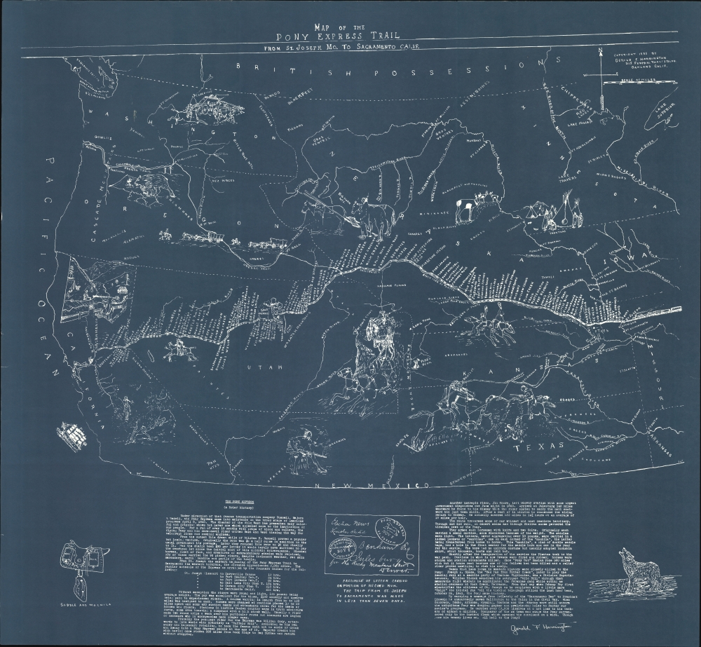
1935 Harrington Map of the Pony Express Route
PonyExpress-harrington-1935$950.00


Title
Map of the Pony Express Trail from St. Joseph Mo. to Sacramento Calif.
1935 (dated) 35.5 x 38.5 in (90.17 x 97.79 cm) 1 : 3250000
1935 (dated) 35.5 x 38.5 in (90.17 x 97.79 cm) 1 : 3250000
Description
This is Gerald F. Harrington's 1935 cyanotype map illustrating the route of the Pony Express. Gerald was a noted Pony Express expert, and this map and his research are widely cited by Pony Express historians.
A Closer Look
Printed in cyanotype or blueprint, the map covers the western United States from Missouri to the Pacific Coast. It loosely outlines the states, highlighting rivers, important cities, and some geological features. The focus is on the Pony Express Route, here shown boldly running between St. Joseph, Missouri, and Sacramento, California. It includes a host of vignettes meant to illustrate the practicalities, challenges, sights, and romance of the Pony Express. Along the bottom of the map is Harrington's brief history of the Pony Express, including multiple historical anecdotes.Pony Express
The Pony Express, operational between April 1860 and October 1861, stands as a testament to human tenacity and innovation. Bridging St. Joseph, Missouri, and Sacramento, California, it promised revolutionary speed in mail delivery across the vast American frontier - essential given the growing, if isolated, population in California and the growing political tensions between the North and South. Fearless riders, battling the elements and challenging terrains, relayed messages from station to station, shrinking a once-tedious journey into roughly 10 days. The accomplishment called for the construction of nearly 200 stations, the hiring of roughly 80 crack riders, and the purchase of more than 400 fast horses. After just 18 months of operation, the Pony Express was made obsolete on October 21st, 1861, when Western Union launched the first transcontinental telegraph system. It went bankrupt days later. Although a commercial failure, the Pony Express remains cemented in the American imagination as a symbol of frontier determination, capturing the indomitable spirit of an age when every obstacle was seen as a challenge to be overcome.Cyanotype: Why so Blue?
Cyanotype is a photo-reprographic technique developed in 1842 by the British astronomer John Herschel (1792 - 1871). Sometimes called a 'sunprint', the technique employs a solution of ferric ammonium citrate and potassium ferricyanide, which painted on white paper or cloth, reacts when exposed to sunlight to dye the object a brilliant blue. Areas blocked from ultraviolet exposure remain undyed and white. Herschel developed the technique to reproduce his astronomical notes, but others quickly realized that any object capable of blocking light could be used to create a cyanotype image quickly and easily. By the late 19th century, the process became popular with designers, military, architects, and engineers (blueprints), who used the cheap and effective technique to quickly and exactly reproduce images in the field. Cyanotyping is limited in that only a single copy can be made at one time, so it was only practical for short-term field work. It is also of note that cyanotypes remain extremely reactive to light and, over time, fade or degrade, making them extremely ephemeral. The process fell out of fashion in most places by the 1920s but remains in use in some parts of the world, such as India and Nepal, to this day.Publication History and Census
This map was drawn and prepared by historian Gerald F. Harrington in Oakland, California, in 1935. The official copyright registration for the map (no 40403) is dated November 30, 1935. The map is scarce, with a small run due to its being issued only as a cyanotype. We see 7 institutional holdings, all of which, as here, are cyanotypes. No market history.Cartographer
Gerald F. Harrington (October 8, 1890 - August 27, 1947) was an American lawyer and historian active in California in the first half of the 20th century. Harrington was born in O'Neil, Nebraska, the son of first-generation Czech immigrants. He studied at the Creighton University (1910), the University of Washington (1913), and Harvard Law School (1914). After initially practicing law in Nebraska, he relocated c. 1930 to Oakland, California. He was a hobbyist big game hunter and rare book collector. He was also an authority on the Pony Express, publishing articles in several magazines and producing several historical maps. He died tragically from a streetcar accident in Oakland. More by this mapmaker...
Condition
Very good. Slight edge wear.
References
OCLC 21803144.