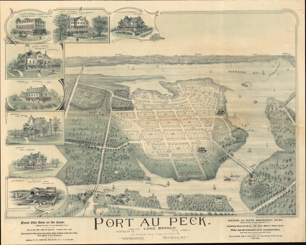
1894 National View Bird's-Eye View Map of Port au Peck, Oceanport, New Jersey
PortauPeckNJ-nationalview-1894$1,100.00

Title
Port au Peck. Near Long Branch. Monmouth Co. New Jersey.
1894 (undated) 22 x 27.5 in (55.88 x 69.85 cm)
1894 (undated) 22 x 27.5 in (55.88 x 69.85 cm)
Description
This is a rare 1894 real-estate promotional bird's-eye view of Port-au-Peck, Oceanport, New Jersey. The view captures the preliminary development of Port-au-Peck as a residential resort community in the late 19th century.
City views were being produced in the United States as early as the 1830s, but the genre exploded after the American Civil War (1861 - 1865). Bridging the gap between maps and pictures, most 19th century American bird's-eye views presented cities to the public from highpoints. Some were imagined, but others were drawn from hot-air balloons or nearby hills. The presentation, combining high elevation, commercial interest, and new printing technology created a uniquely American artform, as described by historian Donald Karshan,
Port-au-Peck
Port-au-peck is a small unincorporated seaside community within Ocean Township, Monmouth County, New Jersey. The name comes from the Lenape name 'Pootapeck'. It was settled as early as the 17th century but remained largely rural farmland until the late 19th century. Much of the Port-au-Peck peninsula was acquired by real estate investor William W. 'Black Bill' Conover. Flush from his success in transforming Rumson, New Jersey, into a resort of the wealthy elite, he turned his attention to Port-au-Peck, acquiring 360 acres there in the 1880s, lotting the land, and laying out a street grid. He hoped to capitalize on Port-au-Peck's proximity to the newly opened Long Branch railroad. The development proceeded much as Conover hoped, although as he died in 1896, shortly after the streets were laid out, he never lived to see it. Today Port-au-Peck is a residential subdivision of Oceanport - which ironically, although located on an inlet, has neither ocean nor port.American Bird's-Eye City Views
The Bird's-Eye view industry emerged in the United States in the middle part of the 19th century and coincided with the commercial development of lithographic printing. Before the rise of lithography, the ability to own and display artwork in the home was largely limited to the extremely wealthy, but the advent of lithographic printing made it possible for everyone to own visually striking artwork. A robust trade developed in portraits of political leaders, allegorical and religious images, and city views.City views were being produced in the United States as early as the 1830s, but the genre exploded after the American Civil War (1861 - 1865). Bridging the gap between maps and pictures, most 19th century American bird's-eye views presented cities to the public from highpoints. Some were imagined, but others were drawn from hot-air balloons or nearby hills. The presentation, combining high elevation, commercial interest, and new printing technology created a uniquely American artform, as described by historian Donald Karshan,
Some print connoisseurs believe that it was only with the advent of the full-blown city-view lithograph that American printmaking reached its first plateau of originality, making a historical contribution to the graphic arts. They cite the differences between the European city-view prints and the expansive American version that reflects a new land and a new attitude toward the land.The vogue for bird's-eye city views lasted from about 1845 to 1920, during which period some 2,400 cities were thus portrayed, some multiple times. Although views were produced in many urban centers, the nexus of view production in the United States was Milwaukee, Wisconsin. The major American viewmakers were Stoner, Wellge, Bailey, Fowler, Hill Ruger, Koch, Burleigh, Norris, and Morse, among others.
Publication History and Census
This view was compiled and published in 1894-95 by the National View Company of Boston for William Conover, a real estate developer in New Jersey. The view may have been part of a real estate prospectus. There are only two known surviving examples, this one, and another held at the Library of Congress.CartographerS
William W. Conover (October 2, 1826 - December 18, 1896), a.k.a. 'Black Bill', was a New Jersey landowner and real estate developer active in the late 19th century. Conover was from a wealthy family based in Red Bank, New Jersey. He made a fortune in cattle, reportedly owning one of the 'largest droves in this country'. Contemporaries describe him as a rough-spoken man with 'no pretense of goodness or charity', but claim this crude exterior hid a big heart, and those who owed him gratitude were innumerable. He was also an ardent abolitionist who served the Union cause during the American Civil War (1861 - 1865) with such rigorous brutality that he earned the nickname 'Black Bill'. For our purposes, he was also keenly interested in real estate. He was instrumental in developing Rumson as a resort of the elite and, in his waning years, duplicated the feat with the acquisition of a large farm, some 360 acres, in Port-au-Peck. His funeral in Red Bank was recorded at the time as the county's largest. More by this mapmaker...
National View (fl. c. 1892 - 1897) was an American publisher of lithographic bird's-eye city views active in the late 19th century. Most of their work focuses on real estate developments in Connecticut, Massachusetts, and northeastern New Jersey. They were based at 36 Columbus Avenue, Boston, Massachusetts. We can find little on the company, although the address, 36 Columbus, seems to have hosted a number of small printing and lithographing firms, among them Blanchard and Watts Engraving, and the American Art Society, both of which would have been contemporaneously in the location with National View. Learn More...
Condition
Very good. Some edge wear and soiling. A few old fold marks.
References
Library of Congress G3814.O4:2P6A3 1895 .N3 (Damaged). OCLC 1048657206.