This item has been sold, but you can get on the Waitlist to be notified if another example becomes available, or purchase a digital scan.
1764 Bellin Map of Port du Carenage, St. Lucia, West Indies
PortCarenage-bellin-1764$87.50

Title
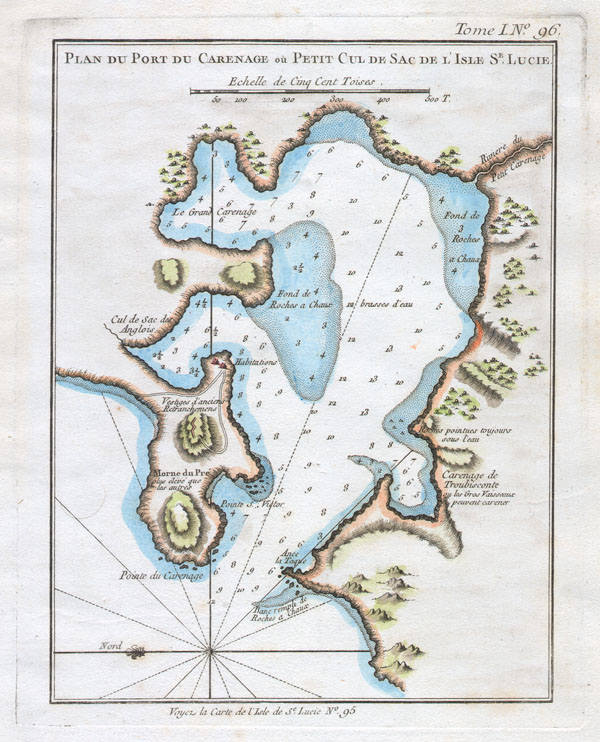
Plan du Port du Carenage ou Petit Cul de Sac de L’Isle St. Lucie.
1764 7 x 9 in (17.78 x 22.86 cm)
1764 7 x 9 in (17.78 x 22.86 cm)
Description
This beautiful little map depicts the Port du Carenage on the south side of the West Indies island of St. Lucia or St. Lucie. Depicts the small bay with numerous depth soundings and information on anchorage for both large and small ships. Also shows some inland features including roads, a small pre-Columbian ruin, and habitations. There is a compass rose decorated with a fleur-de-lys and radiating rhumb lines. This map was published in 1764 for Bellin's Le Petit Atlas Maritime.
Cartographer
Jacques-Nicolas Bellin (1703 - March 21, 1772) was one of the most important cartographers of the 18th century. With a career spanning some 50 years, Bellin is best understood as geographe de cabinet and transitional mapmaker spanning the gap between 18th and early-19th century cartographic styles. His long career as Hydrographer and Ingénieur Hydrographe at the French Dépôt des cartes et plans de la Marine resulted in hundreds of high quality nautical charts of practically everywhere in the world. A true child of the Enlightenment Era, Bellin's work focuses on function and accuracy tending in the process to be less decorative than the earlier 17th and 18th century cartographic work. Unlike many of his contemporaries, Bellin was always careful to cite his references and his scholarly corpus consists of over 1400 articles on geography prepared for Diderot's Encyclopedie. Bellin, despite his extraordinary success, may not have enjoyed his work, which is described as "long, unpleasant, and hard." In addition to numerous maps and charts published during his lifetime, many of Bellin's maps were updated (or not) and published posthumously. He was succeeded as Ingénieur Hydrographe by his student, also a prolific and influential cartographer, Rigobert Bonne. More by this mapmaker...
Condition
Fine or perfect condition. Original platemark visible. Wide clean margins. Blank on verso.