This item has been sold, but you can get on the Waitlist to be notified if another example becomes available, or purchase a digital scan.
1828 Bougainville Nautical Map of Port Jackson, Sydney, Australia
PortJackson-bougainville-1828$1,000.00

Title
Plan du Port Jackson : Levé à bord de la Frégate la Thétis par M. le Baron de Bougainville.
1828 (dated) 19.75 x 25 in (50.165 x 63.5 cm) 1 : 20000
1828 (dated) 19.75 x 25 in (50.165 x 63.5 cm) 1 : 20000
Description
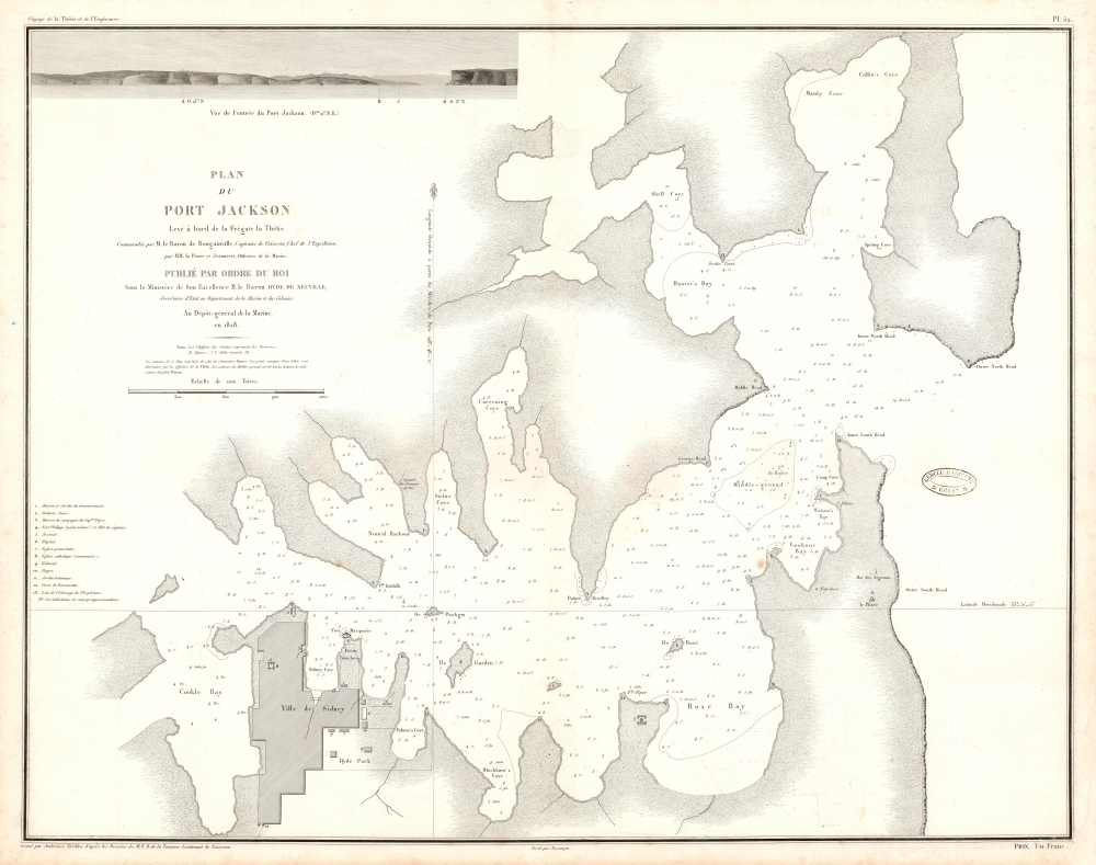
This 1828 Bougainville nautical map of Port Jackson, Sydney, Australia is the earliest acquirable, detailed chart of Port Jackson and the approaches to Sydney, in New South Wales. It appeared in the circumnavigator Bougainville's Journal de la Navigation autour du Globe de la Fregate la Thetis et la Corvette l'Esprance Execute pendant les Annees 1824, 1825 et 1826.
The Chart
Superbly engraved for the Dépôt Général de la Marine by Ambrose Tardieu, the chart shows the nautical approaches to the old town of Sydney via Port Jackson. It is a working chart: not only depth soundings, but notations of the quality of the sea bottom are meticulously incorporated. The coastlines are shown pictorially, distinguishing between the cliffs facing the ocean and the sandy inward-facing coves. The plot of the is shown only in outline, but key features and buildings are shown in detail. Sir Henry Browne Hayes' Vaucluse House is marked, across Lookout Bay from the pilot-house overlooking Watson's Bay. The signal station and Macquarie Lighthouse are shown as well. Both shown on the map and keyed to a list are the Governor's house and garden, the Dawes Point Battery, Forts Philipp and Macquarie, the arsenal, hospital and prison. The Royal Botanical Garden is shown as well, and the town gate on the route to Parramatta.The View
On the upper-left-hand corner of the chart is a well-executed coastal view of the entrance to Port Jackson. The lighthouse and South, North and Middle head are marked with letters, keyed to the chart along with their compass headings.Bougainville's Visit
Bougainville's voyage around the world brought him to Sydney in 1825. His visit was a busy one. He set up a monument to La Pérouse overlooking Botany Bay and became acquainted with many of the prominent members of Sydney society, including John Piper, Samuel Marsden, John Macarthur, and John Blaxland. He became rather more closely acquainted with Blaxland's eldest daughter Harriott, with whom he had a romantic tryst despite her marriage to Calcutta merchant Alexander Macdonald Ritchie.Publication History and Census
The chart is rare. OCLC shows one copy in the National Library of Israel, and another in the National Library of Australia. We are aware of only a few copies appearing on the market in the past fifteen years.CartographerS
Hyacinthe Yves Philippe Potentien, baron de Bougainville (December 26, 1781 – October 18, 1846) was a French naval officer. He was the son of Louis-Antoine de Bougainville.[1] He became Rear-Admiral on 1 May 1838. He circumnavigated the world between 1824 and 1826 aboard the ships Thétis and Espérance. In 1825, Hyacinthe de Bougainville led an unsuccessful embassy to Vietnam; that same year, he visited Port Jackson and Sydney where he set up a monument to La Pérouse and erected a grave for le Receveur in Botany Bay. More by this mapmaker...
Dépôt des Cartes et Plans de la Marine (fl. 1720 - present), often called the Dépôt de Marine, was a French hydrographic mapping organization founded in 1720 under Charles-Hercule of Albert de Luynes (1674 - 1734). Much like the U.S. Coast Survey, the British Admiralty, and the Spanish Deposito Hydrografico, the Dépôt was initiated as a storehouse and distribution center of existing nautical and marine charts. Eventually the Dépôt initiated its own mapping activities in an attempt to improve and expand upon existing material. Some of the more prominent cartographers and hydrographers associated with the of Dépôt des Cartes were, Philippe Buache, Jacques-Nicholas Bellin, Giovanni Rizzi-Zannoni, Rigobert Bonne, and Jean Nicolas Buache. Learn More...
Ambroise Tardieu (March 2, 1788 - January 17, 1841) was a prominent French cartographer and engraver operating in the late 18th and early 19th centuries. He was member of the large and prolific Tardieu family, which, for over 200 years, produced multiple skilled and active engravers. Tardieu's work is known for its beauty and accuracy as well as for its depth of detail. Tardieu's most important work is his version of John Arrowsmith's large format map of the United States, published in 1806. Ambroise Tardieu is eclipsed in fame by his son, artist and medical scholar, August Ambroise Tardieu. Ambroise Tardieu is also frequently confused with Jean Baptiste Pierre Tardieu, another unrelated French map and print engraver active in the early 19th century. Learn More...
Source
Bougainville, L. A. de, Journal de la Navigation autour du Globe de la Frégate la Thétis et de la Corvette l'Espérance pendant les années 1824, 1825 et 1826, (Paris: Depot de la Marine) 1828.
Condition
Very good. Margin reinstated at insertion point, not affecting image.
References
OCLC 234097447.