This item has been sold, but you can get on the Waitlist to be notified if another example becomes available, or purchase a digital scan.
1928 Pictorial City Map of Portland, Maine
Portland-dudley-1928$475.00

Title
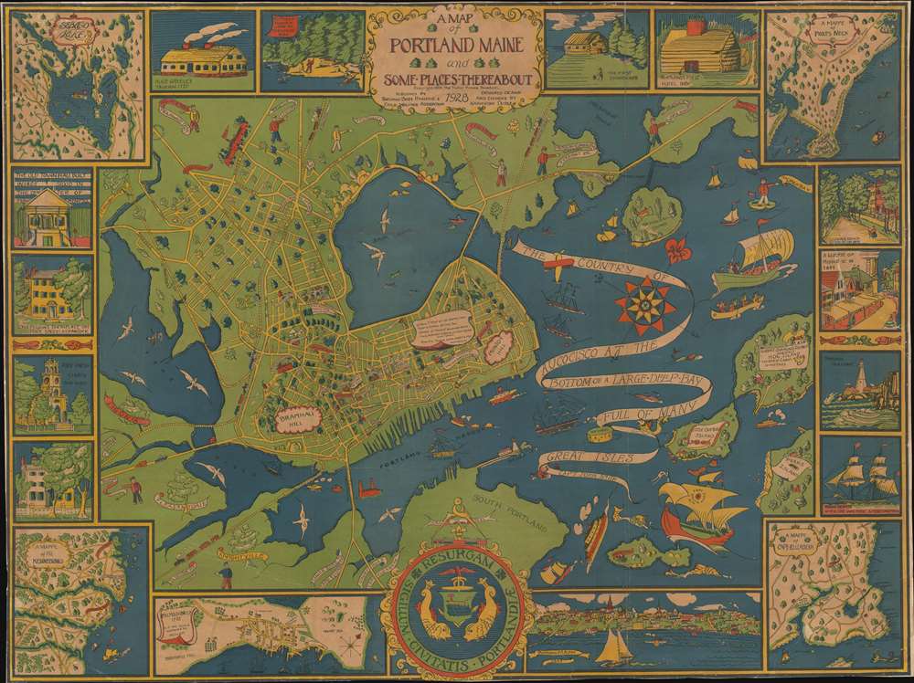
A Map of Portland Maine and Some Places Thereabout.
1928 (dated) 29.25 x 39.25 in (74.295 x 99.695 cm) 1 : 70000
1928 (dated) 29.25 x 39.25 in (74.295 x 99.695 cm) 1 : 70000
Description
This is a 1928 Katherine Dudley pictorial city map or plan of Portland, Maine. The map depicts the region from the Fore River to Mackworth Point and from the Presumscot River to Fort Scammel and House Island. Wonderfully, almost whimsically, illustrated, buildings throughout town are illustrated in profile and labeled with white banners, including schools, churches, the hospital, the public library, and the Y.M.C.A. Roads throughout town are illustrated as well and the major ones are labeled. Bug Light marks the entrance to Portland Harbor and the bay is filled with ships. Captain John Smith's vessel, which arrived in 1614, is among those present, as is the Canceau, the Spitfire Bomb, and Captain Levett's expedition, which appeared in 1623. The whole is bordered by a series of vignettes and inset maps depicting such things and Portland's first church, first hotel, views State Street and Middle Street, and a view of Portland itself. The maps focus on Falmouth Neck, the Kennebunks, Sebaco Lake, and Prouts Neck
Publication History and Census
Created as a promotional piece for the Portland Baby Hygiene and Child Welfare Association (of which Dudley was a member), the map was 'designed, drawn, and colored by Katherine Dudley', copyrighted by the Tudor Press, and published by the Portland Baby Hygiene and Child Welfare Organization in 1928. The Portland Baby Hygiene and Child Welfare Organization was founded in 1919, was renamed the Catherine Morrill Day Nursery in 1920, and recently celebrated its 100th anniversary. The OCLC records examples in the institutional collections of the Osher Map Library and the David Rumsey Map Collection at Stanford University.CartographerS
Katherine Dudley (April 20, 1875 - March 5, 1969) was an American artist and social advocate. Born in Iowa, Dudley was a member of the Baby Hygiene and Child Welfare Association in Portland when it was founded in 1919. She married Frederic C. Dudley around 1899, with whom she had five children. She died in Portland, Maine. More by this mapmaker...
Tudor Press (fl. 1910 - 1967) was a Boston based lithograph, offset, and letterpress printer active in Boston throughout the 20th century. They were founded by Ralph Harland Wilbur (1875 - 19??). Wilber learnt the printing trade at the Melrose Journal, a job and book printing business. He struck out on his own, founding Tudor Press in 1910, with offices on Causeway Street, Boston. Ralphs children, Harland, Alvra, and Wesley joined the firm in the 1920s. The press acquired its first four-color offset press in 1940 and was active in printing maps for the war effort. Harland took over the firm in 1941. After World War II, the firm was contracted to issue military currency for U.S. Occupation forces. In 1967, it was relocated to Lawrence, Massachusetts and renamed Graphic Litho. Harland's son Ralph E. Wilbur, took over the firm in 1968. While the name Tudor Press is no longer used, Graphic Litho remains in business. Learn More...
Condition
Average. Full professional restoration. Backed on archival tissue. Several areas of manuscript infill. Blank on verso.
References
Rumsey 8617.000. OCLC 953572771, 451144837.