This item has been sold, but you can get on the Waitlist to be notified if another example becomes available, or purchase a digital scan.
1700 Nicholas Visscher II Map of Portugal
Portugalliae-visscher-1700$300.00

Title
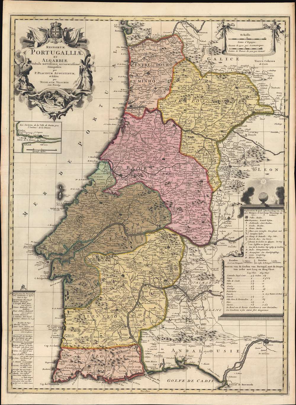
Regnorum Portugalliae et Algarbiae Tabula Novissima accuratissime Composita per P. Placidium Augustinum, et Edita par Nicolaum Visscher.
1700 (undated) 28.25 x 20.75 in (71.755 x 52.705 cm) 1 : 970000
1700 (undated) 28.25 x 20.75 in (71.755 x 52.705 cm) 1 : 970000
Description
A striking c. 1700 old-color Nicholas Visscher II and Placide de Sainte Hélène map of Portugal, published at the height of Portugal's Golden Age, before the disastrous 1755 Great Lisbon Earthquake. The map depicts all of Portugal, including the Algarve and adjacent parts of Galicia, Leon, and Andalucía. An inset in the upper left quadrant illustrates the Duero River and Porto. Due to the contribution of the Augustinian geographer Placide de Sainte Hélène, this map is larger and considerably updated from previous Dutch maps of Portugal, including Visscher family maps.
Publication History and Census
This map is undated, but exists in at least two states: the present example represents the first edition, bearing the Visscher imprint and privilege, c. 1700, and a later, c. 1735 reissue by Petrus Schenk. Scarce to the market - more so than earlier Visscher maps of Portugal, but more common in the Schenk edition.CartographerS
Claes Jansz Visscher (1587 - 1652) established the Visscher family publishing firm, which were prominent Dutch map publishers for nearly a century. The Visscher cartographic story beings with Claes Jansz Visscher who established the firm in Amsterdam near the offices of Pieter van den Keer and Jadocus Hondius. Many hypothesize that Visscher may have been one of Hondius's pupils and, under examination, this seems logical. The first Visscher maps appear around 1620 and include numerous individual maps as well as an atlas compiled of maps by various cartographers including Visscher himself. Upon the death of Claes, the firm fell into the hands of his son Nicholas Visscher I (1618 - 1679), who in 1677 received a privilege to publish from the States of Holland and West Friesland. The firm would in turn be passed on to his son, Nicholas Visscher II (1649 - 1702). Visscher II applied for his own privilege, receiving it in 1682. Most of the maps bearing the Visscher imprint were produced by these two men. Many Visscher maps also bear the imprint Piscator (a Latinized version of Visscher) and often feature the image of an elderly fisherman - an allusion to the family name. Upon the death of Nicholas Visscher II, the business was carried on by the widowed Elizabeth Verseyl Visscher (16?? - 1726). After her death, the firm and all of its plates was liquidated to Peter Schenk. More by this mapmaker...
Placide de Sainte Hélène (1648 - 1734), aka Placidium Augustinum, was a French geographer and Augustine monk. He is the brother of the French royal geographer to King Louis XIV, Pierre Du Val (1619 - 1683). He took orders in Augustine orders in 1666. In 1705, he was awarded the position of Géographe Ordinaire du Roi. Placidus, as he is known, contributed significantly to French and Dutch cartography in the late 17th and early 18th centuries. His name appears on dozens of maps, some very significant. He also completed a study of the Course of the Po River. Learn More...
Condition
Very good. Slight fold wear.
References
OCLC 902704634.