1924 Natural Resources Intelligence Service Map of Canadian Prairie Provinces
PrairieProvinces-nris-1924$450.00


Title
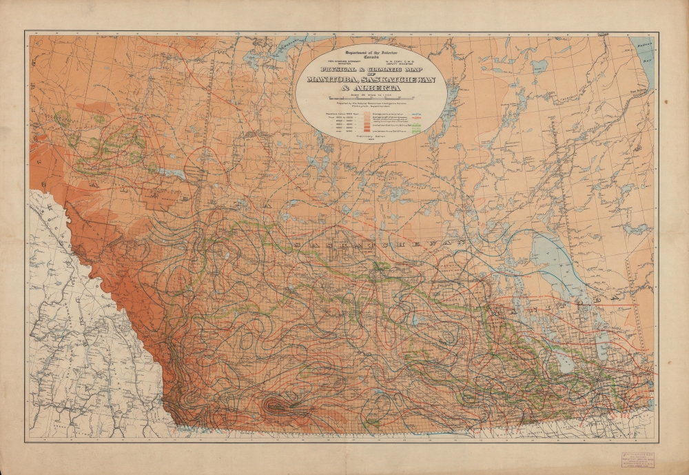
Physical and Climatic Map of Manitoba, Saskatchewan and Alberta.
1924 (dated) 21.25 x 32.5 in (53.975 x 82.55 cm) 1 : 2217600
1924 (dated) 21.25 x 32.5 in (53.975 x 82.55 cm) 1 : 2217600
Description
An impressive large-format map of the 'Prairie Provinces' of Manitoba, Saskatchewan, and Alberta, produced in 1924 by the Natural Resources Intelligence Service of the Canadian Department of the Interior. It both reflected and aided the transformation of these provinces from frontiers inhabited mostly by indigenous people to farmland, settled by Europeans and their descendants, crisscrossed by railways.
Reserves of land, set aside for national parks, forests, mining, or native peoples (Indian Reserves, abbreviated 'I.R.') are also noted. Outside of the Indian Reserves, indigenous peoples had a degree of rights on most of the land seen here according to a series of treaties (Numbered Treaties) brokered in the late 19th and early 20th century, though these treaties did allow the Crown to utilize lands for railways, mining, and other purposes deemed to be in the public interest. European-descended settlers were initially small in number and primarily interested in trading and extracting resources, such as furs and coal, but farmers arrived in greater numbers in the late 19th century, railways proliferated, and cities, especially Edmonton and Calgary, began to appear.
A Closer Look
Coverage includes the provinces of Manitoba, Saskatchewan, and Alberta to the 58th Parallel north, with portions of neighboring provinces and U.S. states. Information relevant for agriculture is recorded, including lines indicating yearly precipitation and the length of the growing season, shading demonstrating elevation, and green lines to delineate prairie, grove belt, and bush country. In addition, survey lines, cities and towns, railways (mostly belonging to the Canadian National and Canadian Pacific), waterways, and other features are marked out in considerable detail.Reserves of land, set aside for national parks, forests, mining, or native peoples (Indian Reserves, abbreviated 'I.R.') are also noted. Outside of the Indian Reserves, indigenous peoples had a degree of rights on most of the land seen here according to a series of treaties (Numbered Treaties) brokered in the late 19th and early 20th century, though these treaties did allow the Crown to utilize lands for railways, mining, and other purposes deemed to be in the public interest. European-descended settlers were initially small in number and primarily interested in trading and extracting resources, such as furs and coal, but farmers arrived in greater numbers in the late 19th century, railways proliferated, and cities, especially Edmonton and Calgary, began to appear.
Publication History and Census
This map was produced by the Natural Resources Intelligence Service of the Canadian Department of the Interior in 1924. A stamp at bottom-right indicates that it was sold by C. S. Hammond and Co. in Boston. The map is fairly well represented in institutional collections, being held by about twenty institutions worldwide, but has no known history on the market.Condition
Good. Light creasing along fold lines and in margins. Slightly uneven toning and light foxing in margins. Loss at bottom-left corner.
References
OCLC 44747674.