This item has been sold, but you can get on the Waitlist to be notified if another example becomes available, or purchase a digital scan.
1817 John Cary Map or Chart of the Principal Mountains of the World
PrincipalMountains-cary-1817$875.00

Title
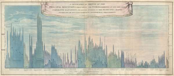
A Geographical Sketch of the Principal Mountains throughout the World; exhibiting at one view their comparative elevations and grouped according to their respective chains founded upon the most exact geometrical admeasurments.
1817 (dated) 20 x 44 in (50.8 x 111.76 cm) 1 : 22000
1817 (dated) 20 x 44 in (50.8 x 111.76 cm) 1 : 22000
Description
An extremely rare and significant separately issued 1817 comparative mountains chart issued by John Cary. The chart juxtaposes in close proximity the mountains of Europe, Asia, Africa, America, and Australia, with particular attention to the British Isles, which are specifically broken out.
BUnlike most similar charts, this chart, due to its great size, offers considerably more reference pints and detail that we have observed in any other comparable chart. In addition to mountains, it also identifies the elevations of some principal towns and cities throughout the world, the Valley of Nepal, and even Egypt's Great Pyramid of Cheops in Egypt. Following on Alexander Von Humboldt's comparative mountains chart, even the September 16th 1814 ballooning feat of the French aeronaut Guy Laussac is noted.
This unusual style of comparative chart, wherein the mountains resemble inverted icicles, was developed in continental in the early part of the 18th century. The style itself is based upon a comparative chart issued by the French scientist M. Pasumont, in the September 1783 issued of Journal de Physique.
This chart is extremely rare. We have identified only two other examples, at Harvard and in the Boston Athenaeum. It is by far the largest comparative mountains we have thus far identified.
B
This unusual style of comparative chart, wherein the mountains resemble inverted icicles, was developed in continental in the early part of the 18th century. The style itself is based upon a comparative chart issued by the French scientist M. Pasumont, in the September 1783 issued of Journal de Physique.
This chart is extremely rare. We have identified only two other examples, at Harvard and in the Boston Athenaeum. It is by far the largest comparative mountains we have thus far identified.
Cartographer
John Cary (1754 - 1835) was a London based cartographer active in the early part of the 19th century. Ronald Vere Tooley, the prominent English map historian, writes of Cary, "As an engraver he was elegant and exact with fine clear lettering and great delicacy of touch." Cary began his work as an engraver, cartographer, and globe maker in 1776 with his New and Correct English Atlas. This important atlas represented a new phase in cartography where accuracy and detail rose in prominence over the decorative embellishments of the 18th century. This change was indicative of the times when travel and commerce were expanding globally as never before. Cary's mastery of both engraving and cartography resulted in a series of seminal works that redefined mapmaking in the early 19th century. His stupendous Cary's New Universal Atlas, published in 1808, set the standard for all cartographers who followed. Cary reissued this seminal atlas in 1811, 1819, 1824, 1828, 1833, 1836 and 1844. Cary also did considerable work on the English Ordinance Survey prior to 1805. His cartographic work particularly inspired the Edinburgh school of cartography as represented by John Pinkerton and John Thomson. In America, Cary's work was used as the basis for Tanner's important New American Atlas. Cary's last published atlas appeared posthumously in 1844, however, by 1850 Cary's work was being carried on by his sons and other well-known cartographers including James Wyld, John Tallis & Company, and Crutchley. More by this mapmaker...
Condition
Very good. Minor verso reinforcement along original fold lines.
References
OCLC 501327162. Boston Athenaeum, G3201.C55 1817 .C37.