
1895 Gamble Map of Florida and a Proposed Cross-Florida Barge Canal

This item has been sold.
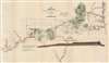
Map of the Country Embraced in the preliminary Survey and Examination of the Peninsula of Florida with a view to the construction of a Ship Canal from the St. Mary's River to the Gulf of Mexico.
Proposed trans-Florida barge canal.
- Digital Map Information
- Suitable for large format printing
- File Size: 28.91 MB
- File Type: ZIP / TIFF
- ICC color profile embedded
- Delivered instantly via download link
Proposed trans-Florida barge canal.
This is an 1895 Robert Gamble map of northern Florida highlighting the route for a proposed cross-Florida barge canal. Illustrated by a red line, the prospective canal was intended connect the Apalachicola River in the west with Camp Pinckney on the Saint Mary's River in the east. Planned to be 100 feet wide and 8 feet deep, the proposed route utilizes some of the 1880 survey work done by Quincy Adams Gillmore (1825 - 1888). A short text in the lower left explains the proposed canal. Our research unearthed very little about the canal. The only mention of the project found was in a Senate report.The Base Map
To create this map, Gamble used a map created by Quincy Adams Gillmore and S.L. Fremont in 1880 to illustrate the construction of a ship canal from the St. Mary's River to the Gulf of Mexico. A bold black line marks this canal, while a black and white dashed line presents the canal route proposed by Gillmore in 1880. Gillmore's map details the region's swamps, lakes, and rivers. It also identifies St. Mary's and Jacksonville. Gillmore's map also included the profile view of the canal. Gamble extended Gillmore's map to the 'west of meridian of range 2 west of Tallahassee', which includes St. James Island, St. George's Sound, and Apalachicola. Gamble also extended the map to the south to illustrate the Suwannee River.Publication History and Census
This map was created by Robert Gamble and published by the Government Printing Office to accompany 'Papers and Map to Accompany Memorial of Maj. Robert Gamble, of Tallahassee, Fla., Showing the Advantages and Value of a Barge Canal Connecting the Waters of the Mississippi River, Through the State of Florida, with the Waters of the Atlantic Seaboard' in The Miscellaneous Documents of the Senate of the United States for the Third Session of the Fifty-Third Congress. 1894 - 95. We note a single cataloged separate example, at the University of South Florida.Source
'Papers and Map to Accompany Memorial of Maj. Robert Gamble, of Tallahassee, Fla., Showing the Advantages and Value of a Barge Canal Connecting the Waters of the Mississippi River, Through the State of Florida, with the Waters of the Atlantic Seaboard', The Miscellaneous Documents of the Senate of the United States for the Third Session of the Fifty-Third Congress. 1894 - 95. (Washington: Government Printing Office) 1895.
Condition
Very good. Backed on archival tissue for stability. Minor infill along right edge. Light toning along original fold lines.