1845 Ewing Map of Prussia
Prussia-ewing-1845$100.00

Title
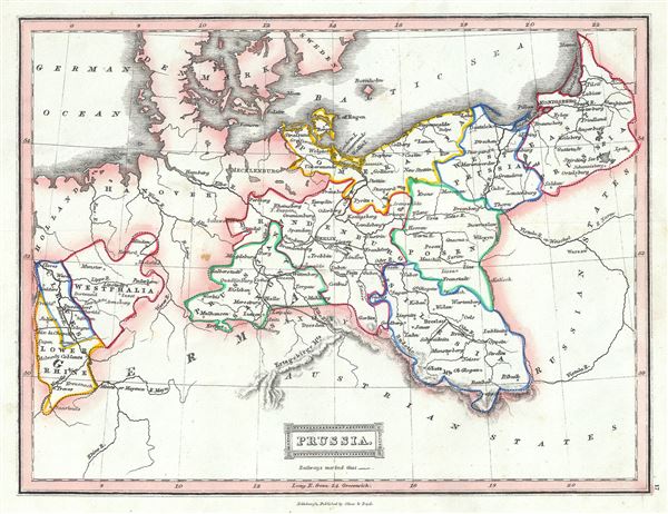
Prussia.
1845 (undated) 8 x 10 in (20.32 x 25.4 cm) 1 : 5000000
1845 (undated) 8 x 10 in (20.32 x 25.4 cm) 1 : 5000000
Description
This is an example of Thomas Ewing's 1845 map of Prussia, Germany. Prussia stretches across the map from Prussian Saxony moving eastward to East Prussia and covers what is today northeastern Germany and Poland. Westphalia, Cleves and Lower Rhine are also included. Various important towns, cities, railways, roads, rivers, mountains and several other topographical details are noted with relief shown by hachure.
Prussia attained its greatest importance in the 18th and 19th centuries when it dominated northern Germany politically, economically, and in population. The German Confederation, created in 1814, acted as a buffer zone between Austria and Prussia, its two largest and most powerful member states. Nonetheless the rivalry between the two powerful states increased until the break out of the Austro-Prussian War. Prussia won the Austro-Prussian War in 1866 that ultimately led to the collapse of the German Confederation. A few years later, in 1871, most of the former Confederation states were folded into the newly proclaimed German Empire
This map was published in 1845 by Oliver and Boyd as part of Ewing's New General Atlas.
Source
Oliver and Boyd, Ewing's New General Atlas: containing Distinct Maps of all the Principal States and Kingdoms throughout the World, (Edinburgh) 1845.
Condition
Very good. Minor foxing at places. Blank on verso.