1956 Deposito Hidrografico Nautical Chart of Mahon Port, Menorca
PuertoMahonMenorca-despositohidrografico-1956$250.00

Title
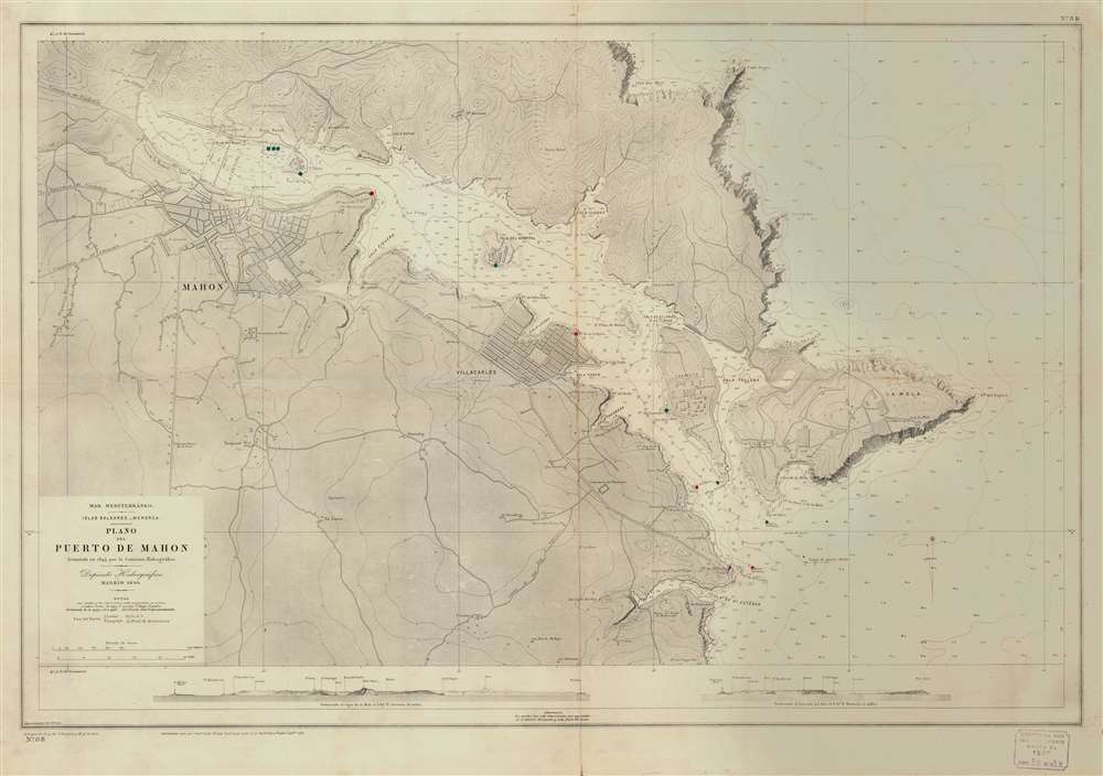
Mar Mediterráneo. Islas Baleares. Menorca. Plano del Pureto de Mahon.
1956 (dated) 27.5 x 39 in (69.85 x 99.06 cm) 1 : 8000
1956 (dated) 27.5 x 39 in (69.85 x 99.06 cm) 1 : 8000
Description
This is a 1956 Depósito Hidrográfico nautical chart or maritime map of Mahon Port on Menorca in the Balearic Islands. Depicting from just west of Mahon (the capital of Menorca) to the Mediterranean Sea and from Cabo Negra to the Cala de San Esteban, the map presents the region's navigational situation. The coastlines are illustrated with fantastic attention to detail, and depth soundings (given in meters) allow mariners a complete understanding of navigational hazards. Manuscript red and green circles mark lights and beacons. Both Mahon and Villacarlos are detailed as well, although no streets are labeled. The military hospital on Hospital Island, the Mahon and Villacarlos cemeteries, and the ruins of the Malborough Fort are also identified. Profile views of the region from the northwest and the southwest are situated just above the bottom border.
Publication History and Census
This chart was originally published by the Depósito Hidrográfico in 1896. Several subsequent editions, with corrections, were published during the first half of the twentieth century, and the present edition was printed in 1954. A stamp in the lower right corner attests that this chart has been corrected to be current as of December 15, 1956. No editions of this map are cataloged in OCLC, and a few incomplete entries appear in other online locations. We have been unable to locate any other examples of the printed 1954 edition or one bearing the manuscript corrections to 1956.Cartographer
The Direccion Hidrografía (1787 - 1927), also known as the Deposito Hydrografico and the Direction de Hidrografía, was the Spanish equivalent of the British Admiralty or the U.S. Coast Survey. This organization, founded in 1787, was commissioned to collect and produce accurate nautical charts of all waters frequented by Spanish vessels. In essence, it replaced the Casa de la Contratación de las Indias (House of Trade of the Indies), which closed its doors in 1790. Like most such organizations, the Direccion Hidrografía marked a new age in cartography. Rather than simply collect charts created by navigators, explorers, and merchants, the Direccion Hidrografía worked closely with naval and military personnel to mount cartographic and hydrographic expeditions in pursuit of the most accurate hydrographical, astronomical, and geodetic measurements. The Direccion Hidrografía created a massive library of nautical charts that, though not nearly as common as similar nautical charts by the U.S. Coast Survey and British Admiralty, are highly desirable for the beauty of their manufacture as well as their accuracy and detail. The office was originally located on Calle Ballesta, but relocated to 36 Alcala, both in Madrid. After 1908 the Dirección was subsumed into other governmental agencies. In 1927 the Direccion was absorbed into the Institute and Observatory of San Fernando, located in Cadiz. The library of original maps, charts, and journals was transferred to the Naval Museum of Madrid - where it resides to this day. More by this mapmaker...
Condition
Good. Exhibits some wear along original fold lines. Manuscript corrections to 1956.