This item has been sold, but you can get on the Waitlist to be notified if another example becomes available, or purchase a digital scan.
1665 Kircher Map of the Interior of the World w/Volcanic and Water Systems
QuvExprimiturAquarum2-kircher-1665$1,250.00

Title
Systema Ideale Qvo Exprimitur, Aquarum per Canales hydragogos subterraneos ex mari et in montium hydrophylacia protrusio, aquarumq. subterrestrium per pyragogos canales concoctus.
1665 (undated) 15 x 17 in (38.1 x 43.18 cm) 1 : 26400000
1665 (undated) 15 x 17 in (38.1 x 43.18 cm) 1 : 26400000
Description
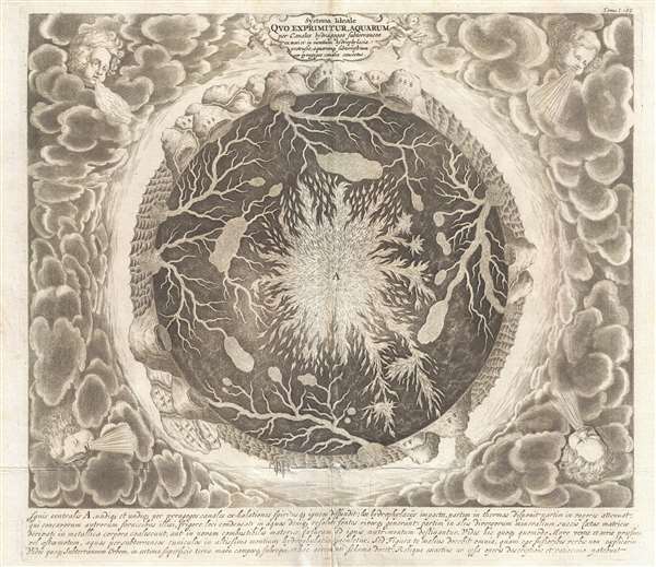
This is one of the 17th century polymath Athanasius Kircher's most iconic and graphically intense maps. This map illustrates the subterranean world and is one of the maps included in Kircher's 1665 cosmography Mundus Subterranous. Inspired by two weeks of earthquakes in Calabria in 1638, and the volcanic eruption of Vesuvius in 1637, Kircher postulated subterranean seas that created currents, earthquakes, and tides by entering and exiting through an extensive network of tunnels and abysses. This map, more than any other, fully illustrates these theories.
Situated amidst dense clouds with Aeolus, or wind heads, at the corners, the Earth appears as a gigantic fiery orb. Around the perimeter, we can recognize the oceans, mountains, land, whirlpools, and even a few sailing ships. The center of the Earth is a great fire. Beyond the flaming core, artery-like networks of subterranean seas and rivers connect great reservoirs hidden under mighty mountains.
BKirtcher quotes the Jesuit priest Peter Paez in describing such features,
This map was issued to accompany the 1665 edition of Kircher's Mundus Subterranous.
Situated amidst dense clouds with Aeolus, or wind heads, at the corners, the Earth appears as a gigantic fiery orb. Around the perimeter, we can recognize the oceans, mountains, land, whirlpools, and even a few sailing ships. The center of the Earth is a great fire. Beyond the flaming core, artery-like networks of subterranean seas and rivers connect great reservoirs hidden under mighty mountains.
B
On the 21st April in the year 1618, being there with the King and his army, I ascended the place and observed everything with great attention: I discovered first two round fountain each bout four palms in diameter, and saw with the greatest delight what neither Cyrus, the King of the Persians, or Cambysis, nor Alexander the Great, nor the famous Julius Caesar could ever discover. The two openings of these fountains have no issue in the plain on top of the mountain but flow from the root of it. The second fountain lies about a stone-cast west from the first: the inhabitants say that this whole mountain is full of water and add that the whole plain about the fountain is floating and unsteady, a certain mark that there is water concealed under it.Kircher's ideas may seem quaint to us today, but he was an excellent observer and a great reasoner. His work with currents in particular is revolutionary and among the first serious scientific studies of this phenomenon. He was also correct in surmising the superheated nature of the Earth's core. While his network of underground lakes and rivers connecting to giant reservoirs under mountain rangers was incorrect, his theory did correctly recognize that earthquakes were caused by the movement of great plates of earth. And, while his assessment regarding the source of the ocean currents was incorrect, his identification of current patters was often accurate.
This map was issued to accompany the 1665 edition of Kircher's Mundus Subterranous.
Cartographer
Athanasius Kircher (c. 1601 - 1680) was a 17th century German Jesuit scholar and one of the most respected and remarkable men of his time. A master of languages, mathematics, science, geography, physics and oriental studies, many consider Kircher to be 'the last true Renaissance man.' Kircher attained almost global fame in his lifetime for his numerous scholarly publications. Indeed, Kircher was the first documented scholar able to fully support himself on his own work, which, in his case, included some forty volumes on diverse fields. As a Catholic in Germany, Kircher was frequently at odds with the rising powers of Protestantism. Consequently, in 1628 he joined the priesthood and after extensive world travels eventually settled in Rome. There he was employed as a Professor of Mathematics and Oriental Languages at the Collegio Romano. Inspired by the eruption of Vesuvius in 1637 and the two weeks of earthquakes that shook Calabria in 1638, Kircher turned his considerable intellect to the natural world. Kircher's research into Geography and Oceanography culminated in the postulation that tides and currents were caused by water moving to and from a great subterranean ocean. Kircher published his geographic work in the important 1664 Mundus Subterraneus, which in addition to several world and oceanic charts, included a fascinating map of Atlantis. Kircher is nonetheless, not unimpeachable. One anecdote tells how a rival scholar presented Kircher with a manufactured gibberish manuscript he claimed to be an recently discovered ancient Egyptian text in need of translation. Kircher produced the translation instantly. In addition to his significance as a scholar, Kircher is best known for his invention of the Magic Lantern, precursor to modern cinema. He also founded the Museum Kircherianum in Rome. More by this mapmaker...
Source
Kircher, A., Mundus Subterranous, (Amsterdam) 1665.
Condition
Very good. Even overal toning. Slight centerfold wear. Else clean.
References
OCLC 633551045.