This item has been sold, but you can get on the Waitlist to be notified if another example becomes available, or purchase a digital scan.
1900 Meekham Map of Raquette Lake, Hamilton County, New York
RaquetteLake-meekham-1900$112.50

Title
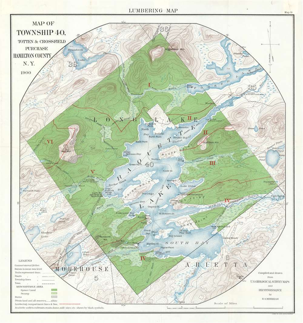
Lumbering Map. Map of Township 40, Totten and Crossfield Purchase. Hamilton County, N.Y.
1900 (dated) 22.25 x 21 in (56.515 x 53.34 cm) 1 : 31700
1900 (dated) 22.25 x 21 in (56.515 x 53.34 cm) 1 : 31700
Description
A both nostalgic and historically significant piece, this 1900 H.S. Meekham map of Raquette Lake in Hamilton County, New York highlights a region known for summer camps and illustrates New York State's drive to protect natural forested land. The map depicts Township 40 from its borders with Townships 39 and 36 to its borders with Townships 5 and 6 and from Township 41 and 5 to Township 35 and Forked Lake. Several locations are labeled around Raquette Lake including Indian Point, Beaver Bay, Antler's Point, Long Point, South Bay, Bluff Point, and North Bay. Camp Pine Knot is depicted on Long Point. The Raquette Lake Railway is illustrated in the lower left quadrant, along with Durant Station and Post Office. Roads, trails, and towns are also noted. Raquette Lake remains a popular summer camp destination to this day.
Thus, a few decades later, the state of New York created a Forest Commission, only the second state to do so, after California. This Forest Commission, however, was covertly connected to the lumber industry and would provide loggers with dodges and other loopholes to get around state law, essentially meaning that the Forest Preserve existed only on paper. This reality forced new Yorkers to find another solution. In 1894, a constitutional convention was held in New York that proposed Article 7 (today Article 14) of the New York State Constitution, which closed every loophole the Forest Commission had found. Amending New York's State Constitution is an incredibly onerous task, requiring the approval of both Assembly and Senate in successive sessions of the legislature and public approval in the next general election. Nonetheless the 'forever wild' Forest Preserve amendment passed. During this process, several attempts were made to amend Article 14 to allow the Forest Commission to placate the loggers while still maintaining the farce of honoring the law. Since 1894, over 2,000 amendments to Article 14 have been introduced in the legislature, of these only twenty-eight have made it to be voted on by the general public, and only twenty have passed.
A Forestry Map and the 'Forever Wild' Amendment
Originally created as a forestry plan, spruce land is noted by the dark green, while swamps are highlighted by light green. The plan begun here, however, was never implemented because the 'Forever Wild' amendment was never successfully repealed. This history begins in the years following the Civil War, when New York State powerbrokers feared that unregulated logging of the Adirondacks could, through erosion, silt up the Erie Canal and end the state's economic advantage.Thus, a few decades later, the state of New York created a Forest Commission, only the second state to do so, after California. This Forest Commission, however, was covertly connected to the lumber industry and would provide loggers with dodges and other loopholes to get around state law, essentially meaning that the Forest Preserve existed only on paper. This reality forced new Yorkers to find another solution. In 1894, a constitutional convention was held in New York that proposed Article 7 (today Article 14) of the New York State Constitution, which closed every loophole the Forest Commission had found. Amending New York's State Constitution is an incredibly onerous task, requiring the approval of both Assembly and Senate in successive sessions of the legislature and public approval in the next general election. Nonetheless the 'forever wild' Forest Preserve amendment passed. During this process, several attempts were made to amend Article 14 to allow the Forest Commission to placate the loggers while still maintaining the farce of honoring the law. Since 1894, over 2,000 amendments to Article 14 have been introduced in the legislature, of these only twenty-eight have made it to be voted on by the general public, and only twenty have passed.
Publication History and Census
This map was compiled by H.S. Meekham in 1900 and printed by James B. Lyon. The only example of which we are aware is part of the David Rumsey Map Collection at Stanford University.Condition
Very good. Old repairs on verso. Blank on verso.
References
Rumsey 12117.000.