This item has been sold, but you can get on the Waitlist to be notified if another example becomes available, or purchase a digital scan.
1730 Ottens Map of Persia (Iran, Iraq, Turkey)
RegnumPersicum-ottens-1730$700.00

Title
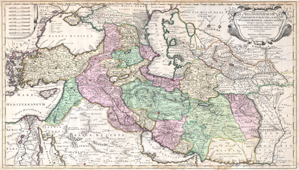
Regnum Persicum Imperium Turcicum in Asia Russorum Provinciae and Mare Caspium.
c. 1730 (undated) 20 x 35 in (50.8 x 88.9 cm)
c. 1730 (undated) 20 x 35 in (50.8 x 88.9 cm)
Description
A scarce and altogether spectacular c. 1730 map of southwestern Asia, specifically focusing on Persia, by Reiner and Joshua Ottens. Covers from Egypt and Greece eastward to include Turkey, the northern part of the Arabian Peninsula, the Black and Caspian Seas, Persia, and Tartary, Afghanistan and Pakistan, including the Indus valley and the western extant of the Mogul Empire. Extends as far north as Asof (Asov) and 'Tibet,' and as far south as Medina. Includes superb detail regarding the early 18th century Silk Route trading routes through Persia and Central Asia, noting the important centers of Samarkand, Bukhara and Tashkent. Generally accurate with only a few notable flaws. Most specifically the positioning of Lake Van and Lake Chahi in close proximity to one another. These lakes are in fact separated by over 160 kilometers. Identifies the Pyramids of Egypt, the ruins of Troy, Mt. Sinai, and Mt. Agerdaghi (Mt. Ararat, but labeled Mt. Noah). Upper right quadrant features an attractive title cartouche with baroque ornamentation. Upper left quadrant has eight distance scales on a curtain.
Cartographer
Ottens (fl. c. 1680 - 1785) was a prominent Amsterdam map publishing family active for nearly 100 years. Joachim Ottens (1663 - 1719) was born in Amsterdam to a family of seafarers and educated in Amsterdam's Evangelical Lutheran community. He likely learned copperplate engraving under Frederick de Wit (1629 - 1706), for whom he worked until about 1710. In 1710, he was admitted to the Sint-Lucasgilde (Guild of St. Luke) and, in 1711, Joachim founded his own firm. Although Joachim died only a few years later, in 1719, his widow continued the business, either publishing as either 'I. Ottens', 'Ottens', or 'In de Wereldcaert' [In the World Map]. In 1726, Joachim Otten's sons, Renier (1698 - 1750) and Joshua (1698 - 1750), established a partnership and generally published as 'R. and I. Ottens'. Although they ran separate shops, on Nieuwendijk and Kalverstraat, they worked jointly as a singular business until Renier's death in 1750, at which point Joshua assumed full control. After Joshua's death in 1765, his widow continued the firm with their son, Renier II, changing the imprint to 'Joshua and Reinier Ottens.' Joshua's widow, Johanna de Lindt, held an auction sale of their engraved plates in 1784. Ottens' work stands out in that all of their maps were separate issues, though often found compiled into special, made-to-order multi-volume composite Atlas factice works, such as the Atlas. Some examples of the Atlas include over 800 separately issued maps. Because they were not uniformly issued in standard atlases, Ottens maps are often of the utmost rarity and are notable for their exceptionally rich engraving. More by this mapmaker...
Source
Independent Issue.
Condition
Very good condition. Top Margin narrow on right side, but intact all around. Very minor water stain most confined to margin, but extening about 1/2 inch into the map in one or two place. Overall very nice condition with original color.
References
Tibbetts, G. R., Arabia in Early Maps: A Bibliography of Maps Covering the Peninsula of Arabia, Printed in Western Europe from the Invention of Printing to the Year 1751, 260. Alai, C. General Maps of Persia 1477 - 1925, 99. British Museum, Map Collections, Maps * 50970.(9.).