This item has been sold, but you can get on the Waitlist to be notified if another example becomes available, or purchase a digital scan.
1702 Stoopendaal Map of the Travels of the Apostle Paul
ReysenPauli-stoopendaal-1702$450.00

Title
De Beschryvingh van de Reysen Pauli, en van de Andere Apostelen.
1702 (undated) 13.5 x 14 in (34.29 x 35.56 cm) 1 : 3587000
1702 (undated) 13.5 x 14 in (34.29 x 35.56 cm) 1 : 3587000
Description
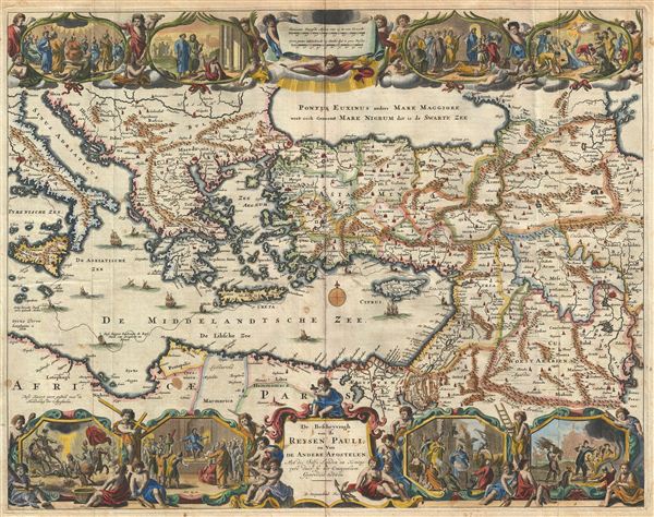
This is a splendid early example of Daniel Stoopendaal and Jacob Keur's 1702 map of the travels of the Apostle Paul. The map covers the eastern Mediterranean from Sicily to the Holy Land and inland as far as the Persian Gulf and the Caspian Sea, including the modern day countries of Israel, Palestine, Cyprus, Jordan, Lebanon, Syria, Turkey, Italy, Georgia, Armenia, Egypt, and Iraq. The travels of Paul between Canaan and Italy are illustrated with a dotted line.
This map is derived from Nicholas Visscher's 1645 map of the same name, and though cartographically nearly identical, features updated decorative elements. These include scenes from the life and travels of the Apostle Paul. Just to the right of the title cartouche a there is fisherman holding an anchor – a nod to Visscher who used the 'fisherman' iconography to represent his patrimony.
This map was published by the Keur family in their popular Keur Bible. As one of the Dutch 'Staten Bibles' published between 1637 and 1760, the Keur Bible contained five or six maps: Werlt Karte, Paradys, Perigrinations, Canaan, Ierusalem, Reysen Pauli, and sometimes Reyse der Kinderen Israels. This specific map was issued in the1702 edition of the Keur Bible.
CartographerS
Daniel Stoopendaal (1672-1726) was a Dutch engraver and mapmaker active in Amsterdam during the early part of the17th century. Stoopendaal is best known for his garden and landscape prints. Cartographically D. Stoopendaal's most notable work is his re-engravings of Visscher maps of the Holy Land for inclusion in the Keur Bible. Daniel Stoopendaal is often confused with Bastiaan Stoopendaal, an engraver associated the Visscher firm, with whom he frequently work but was most likely not related. More by this mapmaker...
Claes Jansz Visscher (1587 - 1652) established the Visscher family publishing firm, which were prominent Dutch map publishers for nearly a century. The Visscher cartographic story beings with Claes Jansz Visscher who established the firm in Amsterdam near the offices of Pieter van den Keer and Jadocus Hondius. Many hypothesize that Visscher may have been one of Hondius's pupils and, under examination, this seems logical. The first Visscher maps appear around 1620 and include numerous individual maps as well as an atlas compiled of maps by various cartographers including Visscher himself. Upon the death of Claes, the firm fell into the hands of his son Nicholas Visscher I (1618 - 1679), who in 1677 received a privilege to publish from the States of Holland and West Friesland. The firm would in turn be passed on to his son, Nicholas Visscher II (1649 - 1702). Visscher II applied for his own privilege, receiving it in 1682. Most of the maps bearing the Visscher imprint were produced by these two men. Many Visscher maps also bear the imprint Piscator (a Latinized version of Visscher) and often feature the image of an elderly fisherman - an allusion to the family name. Upon the death of Nicholas Visscher II, the business was carried on by the widowed Elizabeth Verseyl Visscher (16?? - 1726). After her death, the firm and all of its plates was liquidated to Peter Schenk. Learn More...
Source
Biblia, dat is De gantsche H. Schrufture, Pieter and Jacob Keur, 1730.
Condition
Very good condition. Original folds. Platemark visible. Text on verso.
References
Poortman, Wilco C., Kaarten in Bijbels, p. 197. Laor, E., Maps of the Holy Land: Cartobibliography of Printed Maps, 1475 - 1900, #812.