This item has been sold, but you can get on the Waitlist to be notified if another example becomes available, or purchase a digital scan.
1840 Arntzen Panoramic Map of the Middle Rhine River, Germany
Rhein-arntzen-1840$150.00

Title
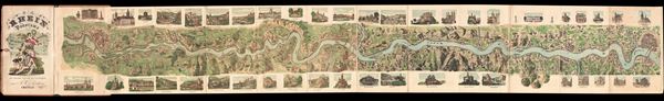
Panorama of the Rhein from Mentz to Cologne. / Panorama du Rhin depuis Mayence jusqua Cologne.
1840 (dated) 10 x 69 in (25.4 x 175.26 cm)
1840 (dated) 10 x 69 in (25.4 x 175.26 cm)
Description
This is a beautiful example of R. W. Arntzen's 1840 panoramic view or map of the Middle Rhine River. This region, today a UNSeCO World Heritage Site known as 'The Romantic Rhine' is one of the most scenic parts of the river, featuring the dramatic Rhone Gorge as well as more than 40 castles and fortresses, vineyards, and quaint country towns. The map or view follows the Rhine River from Mainz to Cologne, with pictorial descriptions of various landmarks, cities, and castles along the way. This extended view features 44 beautifully illustrated pictorial vignettes, including St. Gereonskirche in Cologne, Dom in Mainz, and Schloss Stolzenfels, among others. The whole is extremely detailed with important buildings and landmarks shown in profile. Numerous ships appear traveling on the river. Folds into original binder with beautiful illustrations of angels on the inside cover. This view was designed, manufactured and distributed by A. W. Arntzen of Crefeld in 1840.
Condition
Very good. Original fold lines visible and exhibit some wear and verso repair. Blank on verso. Folds into original binder.