This item has been sold, but you can get on the Waitlist to be notified if another example becomes available, or purchase a digital scan.
1940 Rand McNally/ Richfield Oil Corp Map of the European Theatre of World War II
Richfield-randmcnally-1940$75.00


Title
Richfield European News Map. / Richfield News Map of Europe.
1940 (dated) 18.75 x 25.75 in (47.625 x 65.405 cm) 1 : 7000000
1940 (dated) 18.75 x 25.75 in (47.625 x 65.405 cm) 1 : 7000000
Description
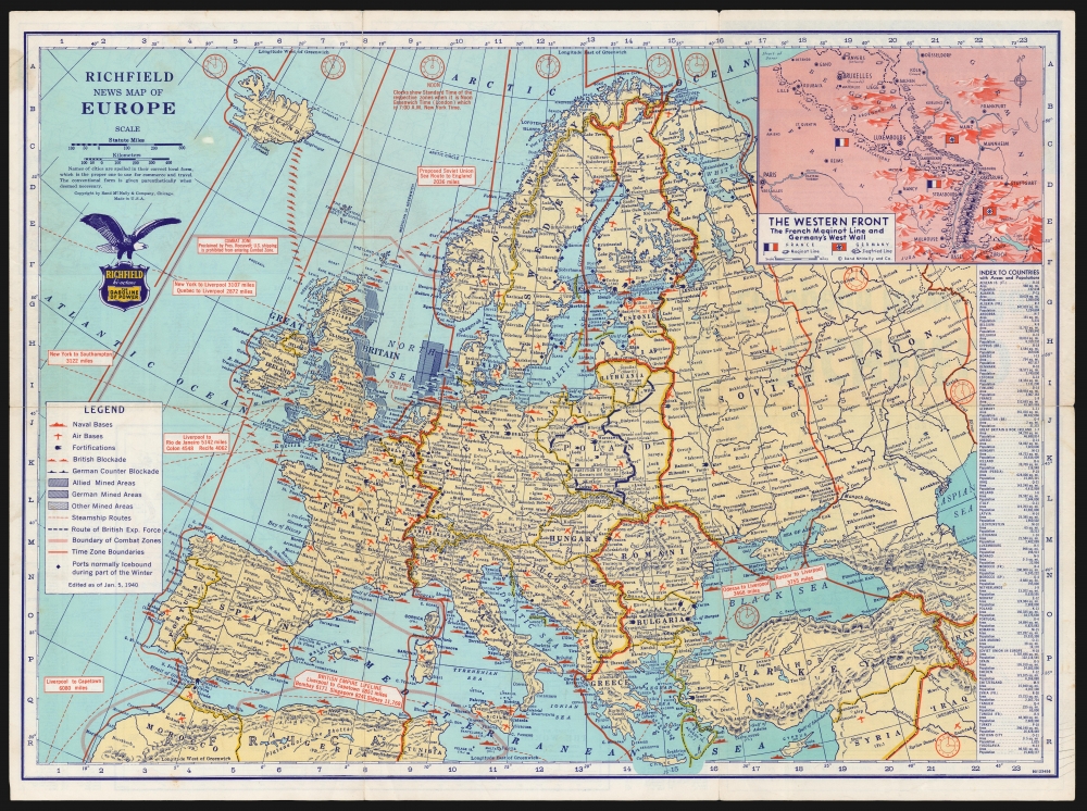
This is a January 1940 Rand McNally Map of Europe, published for the Richfield Oil Corporation as a promotional item, probably for distribution at the company's service stations. It is an information-rich map, presenting the European theater of war to an American audience. Although it was nearly two years before the United States entered the war, the proliferation of such maps as this reveals the intense interest and unease with which Americans perceived the war.
The primary map presents the pre-war borders of the European nations, but these are less prominent than the boundaries assigned to regional time zones, allowing the reader to calculate local times in relation to New York time. The map also includes the overall boundaries of the recognized combat zones. The partition of Poland is marked out; Slovakia is presented as a 'protectorate' (having seceded from Czechoslovakia and become a client state of Germany.) The British blockades of the English Channel and the North Sea are marked, as are the German blockades of the German coast, and the Baltic. The positions of naval bases, air bases, and major land fortifications are also identified with appropriate symbols on the map. Steamship routes are noted in dotted lines, and the distances of sea-voyages between key cities are noted. An index to countries, keyed to coordinates on the map's border, appears in a box in the lower right. In addition to references to the fixed land defenses, naval minefields are also indicated: another emphasis on the assumption that this war, like the Great War, would be a static conflict.
A Closer Look
The recto map displays he theatre of what was dubbed the 'Phoney War:' Germany had invaded Czechoslovakia; Germany and Russia, enjoying their non-aggression pact, had partitioned Poland. Britain and France had, by the time this map was produced, been at war with Germany for some four months. Nevertheless, this stage of the war had seen only very limited Allied operations: the French invasion of Germany's Saar district. The inset at the upper right of the map detailing the French Maginot Line reveals the naïve hopes that this new European conflict would prove a simple re-play of World War I. These hopes had yet, in January of 1940, to be proven ill-founded.The primary map presents the pre-war borders of the European nations, but these are less prominent than the boundaries assigned to regional time zones, allowing the reader to calculate local times in relation to New York time. The map also includes the overall boundaries of the recognized combat zones. The partition of Poland is marked out; Slovakia is presented as a 'protectorate' (having seceded from Czechoslovakia and become a client state of Germany.) The British blockades of the English Channel and the North Sea are marked, as are the German blockades of the German coast, and the Baltic. The positions of naval bases, air bases, and major land fortifications are also identified with appropriate symbols on the map. Steamship routes are noted in dotted lines, and the distances of sea-voyages between key cities are noted. An index to countries, keyed to coordinates on the map's border, appears in a box in the lower right. In addition to references to the fixed land defenses, naval minefields are also indicated: another emphasis on the assumption that this war, like the Great War, would be a static conflict.
The Verso
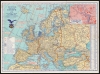
The reverse contains the folding map's cover, and a lengthy index of cities found on the recto. In addition, it includes four detail maps. One, a world map centered on the western hemisphere, highlights the European combat zone (to which Roosevelt had prohibited American shipping) and the Pan-American neutrality zone, encompassing the United States, Mexico, and all of Central and South America. Two detail maps of Europe show that continent's borders as of 1914 and 1921, respectively: revealing the effects of World War I on European borders. The detail map in the lower left presents the air mileage distances between key cities in Europe. Japan, of course, is mentioned nowhere.Publication History and Census
Rand McNally produced News Maps for Richfield as far back as 1939 and would continue to do so throughout the war, beginning first with News Maps of Europe and shifting to 'World-Wide' news maps as the conflict exploded. OCLC lists examples dated February 1, April 18, June 19, and November 15, 1940. We see no listing of this January 5 edition in institutional collections.Cartographer
Rand, McNally and Co. (fl. 1856 - present) is an American publisher of maps, atlases and globes. The company was founded in 1856 when William H. Rand, a native of Quincy, Massachusetts, opened a print shop in Chicago. Rand hired the recent Irish immigrant Andrew McNally to assist in the shop giving him a wage of 9 USD per week. The duo landed several important contracts, including the Tribune's (later renamed the Chicago Tribune) printing operation. In 1872, Rand McNally produced its first map, a railroad guide, using a new cost effective printing technique known as wax process engraving. As Chicago developed as a railway hub, the Rand firm, now incorporated as Rand McNally, began producing a wide array of railroad maps and guides. Over time, the firm expanded into atlases, globes, educational material, and general literature. By embracing the wax engraving process, Rand McNally was able to dominate the map and atlas market, pushing more traditional American lithographic publishers like Colton, Johnson, and Mitchell out of business. Eventually Rand McNally opened an annex office in New York City headed by Caleb S. Hammond, whose name is today synonymous with maps and atlases, and who later started his own map company, C. S. Hammond & Co. Both firms remain in business. More by this mapmaker...
Condition
Good condition. Original fold lines; mended at junctures of some folds visible on verso. Few minor marginal stains.
References
Not in OCLC.