This item has been sold, but you can get on the Waitlist to be notified if another example becomes available, or purchase a digital scan.
1865 War Department U.S. Civil War Map of Richmond and Petersburg, Virginia
RichmondPetersburg-wardept-1865$250.00


Title
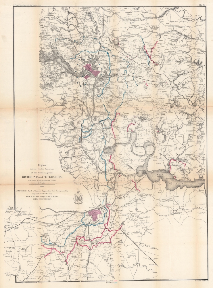
Region embraced in the Operations of the Armies against Richmond and Petersburg.
1865 (dated) 33 x 24.5 in (83.82 x 62.23 cm) 1 : 80000
1865 (dated) 33 x 24.5 in (83.82 x 62.23 cm) 1 : 80000
Description
This is an 1865 War Department map of Richmond and Petersburg, Virginia, and Environs. This piece presents the military situation near the end of the Richmond-Petersburg Campaign of the American Civil War (1861 - 1865). It was partially compiled from a captured Confederate photograph map.
A Closer Look
Richmond and Petersburg immediately catch the viewer's eye, as both are shaded a light reddish hue. Confederate works are highlighted in blue while Union works are colored red, among which are forts and trenches constructed by both sides. The critical railroad network leading into and out of Petersburg is illustrated in detail with each line identified by name. City Point, the site of General-in Chief Ulysses S. Grant's field headquarters, appears above and to the right of Petersburg along the James River. Innumerable towns, villages, and private homesteads are labeled throughout.Richmond-Petersburg Campaign
Richmond was strongly defended by General Lee and the Army of Northern Virginia but suffered privation over the ten-month Richmond-Petersburg Campaign (June 9, 1864 - March 25, 1865). Although popularly known as the Siege of Petersburg, the campaign did not take the form of a classic military siege, instead it consisted of nine months of brutal trench warfare, presaging the horrors of World War I (1914 - 1918). The campaign was marked by countless minor engagements, with most of the fighting near Richmond taking place in October 1864 at Darbytown and Fair Oaks. By the end of the campaign, over thirty miles of trenches stretched from the outskirts of Richmond to the eastern and southern outskirts of Petersburg. Richmond never came under direct Union assault. Instead, the Confederate government elected to flee the city on 'Evacuation Sunday', April 2, 1865, via the last open railroad, the Richmond and Danville. Retreating Confederate soldiers were under orders to burn the armory, bridges, and any supplies. Since the city was mostly abandoned, the fires spread out of control, leading to a city-wide conflagration known as the Evacuation Fire. Union troops entered the city the following day (April 3) and promptly staunched the flames, beginning the occupation of Richmond. General Lee and the Army of Northern Virginia surrendered to General Grant seven days later on April 9, 1865, effectively ending the American Civil War.Publication History and Census
This map was created and published by the War Department in 1865 from a captured Confederate photograph map and from surveys conducted by Nathaniel Michler for publication as part of a report to the 1st Session of the 39th Congress. It is well represented in institutional collections but is rare on the private market.CartographerS
Nathaniel Michler (September 13, 1827 - July 17, 1881) was an American military officer and mapmaker who served during the American Civil War. Born in Easton, Pennsylvania, Michler attended West Point, from which he graduated seventh in his class. Commissioned as a 2nd Lieutenant in the Topographical Engineers, Michler participated in the Mexican Boundary Survey from 1851 until 1857, when he was transferred to serve as the chief topographical engineer in surveys for a proposed canal from the Gulf of Darien to the Pacific Ocean from 1858 until 1860. He held the rank of Captain at the outbreak of the American Civil War and served with the Army of the Cumberland from 1861 - 1863, then was transferred to the Army of the Potomac and built defensive works for the Union Army at the Battles of the Wilderness, Spotsylvania, Cold Harbor, and Petersburg. He was promoted to Colonel in August 1864 and brevetted Brigadier General in April 1865. After the war, Michler served as superintendent in the District of Columbia until 1871 and from 1872 to 1875 was chief engineer with the General Commanding Division of the Pacific. He acted as military attaché for the United States Legation in Vienna, Austria from 1878 to 1880. More by this mapmaker...
John T. Bowen (b. c. 1801 - 1856) was a lithographer active in Philadelphia during the mid-19th century. Born in England, Bowen immigrated to the United States in 1834 and worked as a colorist and lithographer in New York City before moving to Philadelphia in 1838, most like with his collaborator and lithographic artist Alfred Hoffy. Once in Philadelphia, Bowen took over the business of Wild and Chevalier, located at 94 Walnut Street, and began publishing History of the Indian Tribes by McKenney and Hall. He also acquired the rights to Wild and Chevalier's series of views of Philadelphia, which he reissued at the end of 1838 and again in a hand colored edition in 1848. By the early 1840s, Bowen's work was garnering praise, and gained a reputation as one of the best lithographers in Philadelphia. He published the 'Architect's Digest' in 1839 and printed plates for Audubon's Quadrupeds (1845 - 1848) and the octavo edition of Birds of America (1839 - 1844). Despite numerous successes, Bowen field for bankruptcy in 1842, though it did not prove to be too much of a hindrance to his career, as, after 1844, he began working predominantly with Audubon and his sons on their works. Over the course of his career, Bowen became the preeminent Philadelphia lithographer and the most important mid-19th century American publisher of publication plates. By Bowen's death in 1856, he had a fairly substantial estate and a prosperous business. His wife, Lavinia, with whom he had a son, took over the business after her husband's passing and the firm Bowen and Company operated until around 1870. Learn More...
Condition
Good. Wear and toning along original fold lines. Some creasing. Old tape repairs on verso at fold intersections and to margin tears.
References
Rumsey 3875.000. OCLC 764746708.