1888 U.S. Navy Hydrographic Office Nautical Map of the Rio de la Plata
RiodelaPlata-hydrographicoffice-1888$750.00


Title
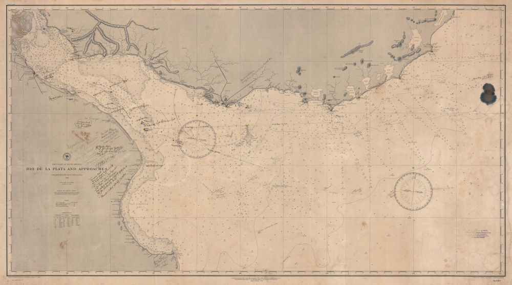
East Coast of South America. Rio de la Plata and Approaches.
1888 (dated) 25.75 x 46.25 in (65.405 x 117.475 cm) 1 : 450000
1888 (dated) 25.75 x 46.25 in (65.405 x 117.475 cm) 1 : 450000
Description
A fascinating working nautical chart, this is an 1888 U.S. Navy Hydrographic Office map of the Rio de la Plata, South America. The map features manuscript annotations following several voyages detailing lights and hazards. It offers unique insight into the navigation of one of the world's most famous estuaries.
A Closer Look
Depicting from the mouth of the Paraná River east to Palmar Point and the Atlantic Ocean, impressive navigational detail appears throughout. Hazards, such as banks and flats, are illustrated. The chart also highlights gaps in its information: for example, some of the banks - such as Ortiz Bank - are labeled as 'imperfectly known'. The manuscript notation shows evidence of navigators' efforts to incorporate new knowledge to improve the chart, such as Cuirassier Bank and the navigational lights evident around the hazard. Pencil arcs and circles define where certain navigational lights (both coastal lights and those attached to buoys or ships) can be seen. Three navigational tracks are traced in pencil. All converge on the Point India Light Ship just below Cuirassier Bank and then proceed towards Buenos Aires. Coastal points, rivers and river mouths, lagoons, mountains, and other features are illustrated, but as is typical with nautical charts, very little inland detail is present. Apart from Buenos Aires, Montevideo and Maldonado are labeled.Publication History and Census
This map was drawn by Harrison Brewer, engraved by Stephen Kubel and John Waddey, and published with updates by the U.S. Navy Hydrographic Office in June 1888. The first edition was published by the Hydrographic Office in 1886. This piece is not cataloged in OCLC, and we note only a handful of instances when it has appeared on the private market. With its abundance of manuscript navigational notations, this chart is a unique one-of-a-kind find.CartographerS
United States Hydrographic Office (1866 - 1962) was a brach of he U.S. Navy that prepared and published maps, charts, and nautical books to aid in navigation. Before the establishment of the Hydrographic Office in 1866, U.S. navigators were almost entirely dependent on British charts. There had been a few private enterprises that had prepared and published charts, but none had been able to do so profitably. The Office was established 'for the improvement of the means of navigating safely the vessels of the Navy and of the mercantile marine, by providing, under the authority of the Secretary of the Navy, accurate and cheap nautical charts, sailing directions, navigators, and manuals of instructions for the use of all vessels of the United States, and for the benefit and use of navigators generally.' This way the Navy Department could furnish navy and merchant ships with charts illustrating the results of surveys and explorations undertaken by naval officers. The charts were priced to cover the cost of paper and printing alone, not preparation. Its main objective was to survey foreign coasts, as the Coast and Geodetic Surveys were responsible for surveying domestic waters. The Hydrographic Office was transferred from the Department of the Navy to the Department of Defense in 1949 and was replaced by the Naval Oceanographic Office in 1962. More by this mapmaker...
Harrison Gaston Brewer (September 21, 1855 - January 22, 1920) was an American draftsman and architect. Born in Annapolis, Maryland, Brewer moved to Washington, D.C. with his family as a child. He earned a degree in Architectural Engineering from Johns Hopkins University and worked for the Navy Department for over 30 years, most of that time spent in the Hydrographic Office as a draftsman. He married Marcie Elliot with whom he had four children, one of whom preceded him in death. Learn More...
Stephen Joseph Kübel (April 2, 1858 - March 2, 1936) was an American musician, cartographer, and map engraver. Born in Washington, D.C., to Edward Kübel and his second wife Josephine Hartbrecht Kübel, Kübel attended high school in Washington, D.C., before attending the Scharwenke Conservatory of Music in Berlin. It was during his time in Berlin that Kübel, who was gifted in drawing, developed an interest in cartography and map engraving. He returned to Washington, D.C., in 1875, and found a job with the U.S. Geological and Geographical Survey of the Territories. He joined the staff of the U.S. Navy Hydrographic Office as a cartographer in 1876. From 1883 through 1885 Kübel served in the cartographic division of the Prussian general staff, where he was able to study alternative map reproduction processes. He rejoined the U.S. Navy Hydrographic Office after returning to Washington, D.C. Kübel opened in his own engraving and printing firm in 1887, employing a staff and fulfilling contracts for the U.S. Geological Survey, the Hydrographic Office, and the U.S. Coast and Geodetic Survey. He was named Chief Engraver of the U.S. Geological Survey on February 14, 1890, and was tasked with organizing a map production plant. He was made the chief of the U.S. Geological Survey's Division of Engraving and Printing in 1911 and became responsible for production of all the Survey's copper engraved maps. Kübel remained the Chief Engraver until his retirement in 1932. Kübel married Louise Griffith of Milford, Delaware, on July 5, 1884, while serving in Berlin. Learn More...
John A. Waddey (December 31, 1852 - January 13, 1932) was a map engraver at the U.S. Navy Hydrographic Office. Born in Georgetown, Waddey apprenticed to William M. McDougal, a Georgetown picture engraver. His first job was with French, Langran, and Ogilvie, who did contract work for the U.S. Navy Hydrographic Office and the Treasury Department. He was appointed to the Hydrographic Office as an advanced apprentice engraver in 1872. At that point, the Hydrographic Office contracted out all its map engraving and only updated its charts in house. The Office had a staff of 12 and only had 24 chart plates. By the time Waddey retired 55 years later, the staff had grown to 154 and the Office had 2,900 charts. Waddey was named Chief Engraver in 1913 and was in charge of a staff of 18 engravers. Learn More...
Condition
Good. Toning and soiling. Ink stain near right border. Manuscript pen and pencil notations throughout.